Islands – Bora Bora – Le Méridien

2014.3.16The storm calmed down in the morning, but the heavy cloud was still hanging low. This is a long exposure shot taken from Le Méridien’s beach.

View of Mount Otemanu and overwater bungalows of Le Méridien Bora Bora
View of Mount Otemanu and overwater bungalows of Le Méridien

Breakfast buffet was held Le Tipanie restaurant. Rain started suddenly during the breakfast. Guests by the water had to move their tables hurriedly. Bora Bora are always connected with blue sky, white beach and palm trees, but this is what we saw in Bora Bora.

Breakfast at Le Méridien Bora Bora

Le Méridien was renovated in 2011. Directly facing Mount Otemanu, the resort has the best view in the island to view Bora Bora’s signature shaped mountain and the lagoon from the beach or from your private patio. The interior is modern and the overwater bungalow has bigger size glass floor than Pearl Resort in Moorea.

Inside the overwater bungalow in Le Méridien Bora Bora
Inside the overwater bungalow of Le Méridien
Inside the overwater bungalow in Le Méridien Bora Bora
Inside the overwater bungalow of Le Méridien

The resort is actively involved in sea turtle protection effort. Bora Bora’s turtle center is located in the resort’s private lagoon. From one side of the pool, you can walk down a couple of stairs and watch the turtles at water level. There were about 15 turtles in the pool. Some of them flew around freely, but others stayed at the corner without making any move for hours.

The Turtle Sanctuary in Le Méridien Bora Bora
The Turtle Sanctuary in Le Méridien

At noon time, it seemed the tropical cyclone finally moved out of the region. The cloud was lighter. It’s soon getting hot with flushes of sunlight started breaking through. We had no plan in the afternoon. On the TV, CNN was reporting repeatedly on the disappearance of MH370 and the progress of Crimea’s referendum; the resort’s channel played Bruno Mars’ “Marry You” endlessly. Besides lying in the room, we also swam in Le Méridien’s inner lagoon.

Lunch at Le Méridien Bora Bora
View of Mount Otemanu from Le Méridien Bora Bora

Night starts to fall. I took some pictures with long exposure to smooth out the sea. Even the sky was covered by the cloud, the contrast between the gray sky and turquoise lagoon was still very striking.

Overwater bungalows of Le Méridien Bora Bora
Overwater bungalows of Le Méridien

More pictures after night fully settled in. Bora Bora was more like the paradise at the time.

Night view of overwater bungalows of Le Méridien Bora Bora again Mount Otemanu
Night view of overwater bungalows of Le Méridien again Mount Otemanu
Night view of overwater bungalows of Le Méridien Bora Bora
Night view of overwater bungalows of Le Méridien
Night view of Le Méridien Bora Bora

The dinner served buffet on Sunday. It’s about $100 per person.

Dinner buffet at Le Méridien Bora Bora
0 Comments

Islands – From Moorea to Bora Bora

2014.3.15We are supposed to leave Moorea at 11:45am to Bora Bora. In the morning, we were worried if we could leave the island on that day, especially after seeing this during breakfast.

Rain stopped after the breakfast. We were told the flight had not been cancelled. At 9:30, a shuttle bus sent us to the airport. Moorea’s airport is small. There were about 30 to 40 passengers on the flight. All of us waited at the airport hall.

Moorea Airport
Moorea Airport

The rain was still on and off but not heavy. At 11am, we were told the flight would be delayed for an hour. Everyone got a coupon for a free drink.

A cat at Moorea Airport

At 12pm, the plane finally arrived. It’s flight from Tahiti. We watched the passenger getting off the plane and walking through the gate. They all looked fine. After all, it’s a only 10-minute flight from Tahiti to Moorea. It would take 45 minutes to get to Bora Bora. We all preyed that the weather wouldn’t become worse in the next hour.

Passengers anxiously waiting for the plane at Moorea Airport

The flight was smooth, only a little bumpy at the end. You should try to take the seat at the left side to be able to overlook the view of iconic overwater bungalows stretching into the turquoise lagoon like tentacles as the plane descending to the Bora Bora Airport.

Overlook Bora Bora's lagoon from the airplane
Overlook Bora Bora’s lagoon from the airplane

Bora Bora Airport is built on a Motu. It seemed even smaller than Moorea’s airport. We were the last ones got off the plane. We let our hotel, Le Meridien, know our arriving date and flight in advance. As we walked out of the gate, the staff from the hotel were waiting for us. They put flower leis on both of us and led us to the boat. There maybe only a few planes leave and land here everyday, but people work very efficiently. We identified our bags and got on the boat. In less than 20 minutes, boats from different hotels all took their guests and gone. (There are free boats to take guests to the town on the island as well.)

Boats welcome guests at Bora Bora Airport

This is it, Bora Bora, the ultimate fantasy and wonderland. As Polynesian music played on the boat and weather was at its best in a few days, we even saw some sunsine, everyone’s spirit got lit up.

It took about half an hour boat ride to get to the hotel. We got our room after checking in. It’s over water but not far from the beach. Look out from our deck, what a view! Bora Bora definitely lives up to the reputation. It would be perfect if only the sky was not that cloudy.

Panoramic view of Mount Otemanu and Le Méridien Bora Bora
The signature view of Mount Otemanu, Bora Bora

After settled in the room, we returned to the lobby to look for something to eat. As we were walking around the central area, the storm hit again. Miki Miki Bar and Restaurant Le Te Ava both face the lagoon and Mount Otemanu by the beach. They were literally damped by the rain and wind. We were really lucky to have this two-hour window of relatively good weather to get here.

Stormy weather at Bora Bora

The storm lasted about 20 minutes. The rain lightened but never really stopped. The staff had to put everything messed up by the storm together. We had a simple lunch at the bar. After that, we caught up with our emails and played a couple of sets of pool games. Hotels on Bora Bora’s Motu are not connected by road. Not many places you could go in this weather.

Garden of Le Meridien Bora Bora

We had our dinner at Le Meridien’s Le Tipanie restaurant. Le Te Ava, normally open for dinner, was closed due to the weather. The food is delicious, looked elegant and expensive, $100 per person is normal.

Dinner at Le Meridien Bora Bora

The storm got severer at night. The overwater bungalows are supported by 4 poles. Every time a big wave hit them, I felt the room was shaking. I really worried that the bungalow could be toppled by the wave. It later turned out my worry was not baseless. Some bungalows in another area of Bora Bora were indeed damaged by the storm at that night.

0 Comments

Islands – Moorea – Circle the Island

2014.3.14Our schedule for the second day was to go to the lagoon excursion tour. Many operators offer the similar programs, which typically visit two bays, feed sharks and rays, snorkel and picnic on a Motu.

We booked the tour through Hiro’s Tours in advance. However, it’s raining heavily in the morning. The front desk told us there was a typhoon passing nearby and it would be with us for another 2 or 3 days!! The tour owner called us and let us know that the tour had to be cancelled. Although the operator associated with our hotel didn’t cancel their tour, we thought it might not worth going so we decided to rent a car to circle around the island.

Car rental with Avis can be arranged at hotel’s concierge desk. The rate is 7000 XPF for 8 hours. The car has to be returned before 5pm, so we actually only had about 6 hours left for the day. Avis’ office is near the ferry station. They sent a van to pick us up.

It’s a steady light rain as we got the car. Our first stop is Sofitel Hotel. Sofitel is known for having the longest beach on the island, but the best place to appreciate the view is to overlook the hotel at the vista point by the main road. Lines of over water bungalows floating over the crystal blue water, even the bad weather couldn’t conceal its beauty.

Panoramic view of Sofitel Moorea Resort

Our hotel, Pearl Resort, is in the walking distance of village Maharepa. We first stopped at a souvenir store and had some ice cream too. Passing the hotel, there is a small shopping center. There is a market, several bank ATMs, restaurants and souvenir stores, but the number of shops that are selling island specialty, black pearls, exceeds other kinds of business.

The Market near Pearl Resort, Moorea

Located between Cook’s Bay and Opunohu Bay, Hilton Moorea Resort is not close to any shops or market, but in terms of service and snorkeling site, it’s deemed as the best hotel in the island. We found their garden was lovely.

Garden of Hilton Moorea Lagoon Resort & Spa

It’s drizzling all the time. Here was spot near on top of Opunohu Bay. It would be very nice if weather had been good.

Near Opunohu Bay, Moorea

InterContinental is the biggest resort in Moorea. We almost walked around the entire resort to look for the Dolphin Center and Turtle Sanctuary. Both of them are at the east side of the resort. Dolphine Center was closed at the moment. We saw at least 3 dolphins crusting around the pool.

Inter-Continental Resort & Spa, Moorea
InterContinental Resort & Spa, Moorea
Inter-Continental Resort & Spa, Moorea
InterContinental Resort & Spa, Moorea

Across a bridge in a small private lagoon, it’s InterContinental’s Turtle Sanctuary. It’s actually a sea turtles clinic. While we were visiting, a staff was feeding an old green turtle who barely wanted to eat and a small hawkbill turtle who is active and full of curiosity.

Turtle Sanctuary, Inter-Continental Resort & Spa, Moorea

It’s almost 3pm when we decided to sit down and have the lunch. Both the guide book and the staff in our hotel recommended Snack Mahana. It’s located about half a mile east to InterContinental Hotel just by the main road. The setup is at its basic and space is small, but the Polynesian food they offer is very tasty and delicious. Their back yard is next to the lagoon, but as it’s raining we had to sit next to the hut under the shield. Interestingly, The couple together with us on the ATV tour the earlier day was also having lunch there. The just came back a private lagoon tour.

Snack Mahana, Moorea

It’s already 1 hour to 5pm after we finished the lunch. We kept on driving to the west side of the island a little bit, but as the rain was getting heavier, we decided to turn back. The storm was on full blast on our way back. The rain was pouring sometimes. We just made it to Avis Car Rental before 5pm.

Overwater bungalow in the heavy cloudy day, Moorea Pearl Resort
2 Comments

Islands – Moorea – ATV Tour

2014.3.13Moorea was settled by Polynesians about 1000 years ago. Although possessing stunning natural beauty and easy-accessibility to Tahati, it’s still relatively less known compared to Bora Bora. Only 20 minutes on the ferry, we were approaching Moorea island.

Near Moorea ferry port

It’s before 7am. We didn’t see any bus service after we got off the ferry. Bus service runs in sync with ferry’s schedule, but it’s said it only starts at 8am. We hailed a taxi after waited for 20 minutes. The driver asked for 2500 XPF ($28), not cheap but acceptable. It took us about half an hour to get to Pearl Resort. The driver pointed us several places and the market we could visit along the way.

We were welcomed with flowers and drinks at the resort’s lobby. It’s 8:30am, it took a while for us to get a room.

The lobby, Moorea Pearl Resort
Infinity Pool, Moorea Pearl Resort

What we booked was a Premium Overwater Bungalow. The overwater bungalow of Pearl Resort is very close to the beach. The premium ones are at the sea side over deeper and clearer water. The inside is roomy.

Inner-view of the overwater bungalow, Moorea Pearl Resort

The stairs on one side of the balcony lead to the lower deck, which has stairs directly into the lagoon. Both of us got down to the water. We saw many small fishes. Some of them were very colorful.

Overwater bungalow, Moorea Pearl Resort

Snorkeling and kayak facilities are free to use. I did some Kayaking around the bungalows before leaving for the ATV tour.

We booked the ATV tour through ATV Moorea Tours. The rate is 21,000 XPF ($240) a bike for the Adventure Raid, and we got 15% discount as we paid in advance using Paypal. The lady from the office came to pick us up at 1pm. She is from France and had been living in Moorea for a couple of years. She told us that she liked Moorea over Bora Bora because Moorea still retained the country-side life style, while Bora Bora had been totally commercialized. One our way to the office, we picked up another young couple from Canada. They were here for their honeymoon.

At the office, everyone was given a helmet. We all looked a bit of funny now. The guide gave us a 5-minute instruction on how to operate the vehicle, and that’s it, we were on our way.

Moorea ATV Tour office

There were only our two couples on the tour. We drove back along the main road for several miles and turned off-road at the bottom of the Opunohu Bay to the inner island.

Moorea ATV Tour
Moorea ATV Tour

We first looped around a plantation of pineapples, coconuts and other tropical fruits. The guide was humorous and never forgot to explain all kinds of vegetation to us and stop for photo opportunities.

The guide explains vegetations, Moorea ATV Tour
The guide explains vegetation, Moorea ATV Tour
Moorea ATV Tour
Moorea ATV Tour

We made a stop at Agricultural College at Opunohu. It’s basically a hovel selling fruit products. We did some tasting of their fresh jams and icecream.

Agricultural College at Opunohu, Moorea ATV Tour

We kept driving up to the mountain. At the end of road, it’s Belvedere Lookout. It’s good place to overlook Moorea’s two almost symmetrical bays, Opunohu Bay and Cook’s Bay, at the same time.

Mt. Mouaroa, Moorea
Mt. Mouaroa, the Sharktooth, Moorea
Overlooking Opunohu Valley, Mt Rotui and Cook and Opunohu Bays from Belvedere Lookout, Moorea

The discover tour would stop here, but we’d continue on. We drove through streams and mud puddles and jumped over slopes. You don’t want to wear shirt in light color, ’cause they’d be covered by splashing mud. We stopped at another high land, where we could see clearly the surrounding mountains. They are the Moorea’s crater wall.

Moorea ATV Tour
Moorea ATV Tour
Moorea ATV Tour
Moorea ATV Tour
Moorea's volcanic crater and plantations, Moorea ATV Tour
Moorea’s volcanic crater and plantations, Moorea ATV Tour

The last leg was to climb the “Magic Mountain”. I’d say that it’s a little scary and probably won’t be allowed in America. We drove the car up and down along a narrow lane on the steep slope without any protection but trees by the road side. The summit offers 360° panoramic view of Moorea’s northern shore. The view is supposedly to be wonderful, but it was a cloudy day and it’s dripping on top of the mountain. At least we could see the island is totally enclosed by the coral reef and lagoons. In fact, it’s almost the best weather we had in French Polynesia. We were lucky to book the ATV tour on our first day of arrival.

Overlook Opunohu Bay at Magic Mountain
Overlook Opunohu Bay at Magic Mountain. The broken reef line is caused by flushing freshwater from the river.

The same lady took us back to the hotel. I randomly took some pictures in the car.

Pao Pao at the bottom of Cook's Bay, Moorea
Pao Pao at the bottom of Cook’s Bay, Moorea
Cook's Bay, Moorea
Cook’s Bay, Moorea

We had dinner at Le Sud. Very plain setting and the food was unimaginative. Mosquitoes were quite active. You should consider wearing long pants or apply DEET if you don’t want to get bitten all over.

0 Comments

North Bay Excursion

2014.5.24~26We decided to have a short excursion to the North Bay during the Memorial Weekend. Leaving home at 4pm, it’s almost 6pm when we got to Sonoma. Most shops had closed.

Sonoma Cheese Factory
Sonoma Plaza
Sonoma Plaza

We had dinner at Della Santina’s. Although Yelp gives it 4-star rating, we found their food to be average.

Della Santina's, Sonoma
Della Santina’s, Sonoma

The hotel we stayed, Embassy Suites at San Rafael, was only 30-minute drive away. The hotel is not luxury but spacious and comfortable. What surprised us is that this hotel features an in-door tropical garden and koi fish pond, very rare in hotels at this level; also the breakfast is included, very rare in hotels in American.

Embassy Suites, San Rafael

I got up early the second day morning. Driving from the hotel to the Golden Gate Bridge took only 15 minutes. I wished to capture the view of the bridge emerging from the early morning cloud. Unfortunately, it’s usual clear day along the coast. It’s only a little hazy but no cloud at all. I still drove along the Conzelman Rd. to the highest view point. This place is just so popular that there is no parking space any time during the day. However this time, it’s too early for normal visitors.

View Golden Gate Bridge from Hawk Hill

What I didn’t know was, the road doesn’t stop at Hawk Hill view point. A one-way road led me down hill to the other side of the peninsula. Just a turn away, the busy city and tourist site gives its way to the peaceful view of countryside. I drove towards Point Bonita Lighthouse and had a short walk to the lighthouse. I couldn’t get access to it because it’s not open on the day, but the view of the tip of the peninsula is quite unusual. I can’t believe this is so close to where we live. The shape of the hill made me feel like in a computer game.

Point Bonita, Sausalito
Near Point Bonita, Sausalito
A few deer near Point Bonita, Sausalito

Our plan for the day was to go to Point Reyes. We went there 10 years ago in the winter. This time we’d walk some trails. Followed the direction of Google Map, we took Lucas Valley Rd to the west. The cell phone soon lost signal once we got into the mountains. We made a turn at Nicasio Valley Rd. to the wrong direction, and landed at Sir Francis Drake Blvd. We took a brief stop at the church by the intersection.

San Geronimo Community Presbyterian Church

It’s about 11am when we reached Point Reyes Station. It’s sunny and warm. The Visitor Center’s parking lot were full. We first walked the Earthquake Trail, which is a half-mile loop. Bear Valley Trail is one of the most popular trails in Point Reyes. It starts at the visitor center and ends at the coast line of Drakes Bay. It’s about 9 miles round-trip. We walked about one mile down and returned.

Near the visitor center at Point Reyes Station
Poppies near the visitor center at Point Reyes Station
Bear Valley Trail, Point Reyes

Olema is along Route 1, only half a mile south to the visitor center. We had the lunch at the Farm House Restaurant.

Farm House Restaurant, Olema

After lunch, we drove along Pierce Point Road to the northern part of the park. We came here 10 years ago and saw a lot of Elks around the Tomales Point Trailhead. We didn’t see any this time. Maybe there were pushed to further north because there were so many visitors.

We walked down McClures Beach Trail to the beach. It’s windy but warm. The valley was covered by many wildflowers.

Wild Flowers on McClures Beach Trail, Point Reyes
McClures Beach, Point Reyes

Returned to Tomales Point Trailhead, we started hiking to the north. Tomales Point Trail is about 10-mile round trip that leads to the Tomales Point. The trail of the first a couple of miles is almost flat and very easy to walk. The wildflowers are blooming along the trail. In terms of the size and variety of flowers, it’s not as good as Mt. Rainier, but close.

Tomales Point Trailhead, Point Reyes
Wild Flowers along Tomales Point Trail, Point Reyes
Look back at McClures Beach from Tomales Point Trailhead, Point Reyes
Overlook Tomales Point, Point Reyes

We walked about 1 mile and returned to our car. It took about 1 hour to get back to the hotel. Only 20 minutes away from San Francisco, we wanted to have dinner at a good Chinese restaurant in the city. Chili House seemed to be a good option. They claim the chef has served two Chinese presidents. We waited until 8:30pm to avoid traffic and crowd. The food is OK, we were not super impressed, but the good thing is they were not too salty.

川流不息 - Chili House, San Francisco
川流不息 – Chili House, San Francisco

The last day morning, after checking out of the hotel, we drove over to China Camp State Park. The park is located at San Rafael. It offers both hill side hiking options and open view of San Rafael Bay.

San Rafael
San Rafael

Driving south on 101 for 5 miles, we took another diversion to exit at Tiburon Blvd. (Route 131) towards the bay. Town of Tiburon is directly facing Sausalito across Richardson Bay. There is a long boardwalk along the coastline. The view of the bay and the Golden Gate Bridge was wonderful. We have never been to Tiburon before but it could very much be our next excursion destination.

Overlook Richardson Bay and Golden Gate Bridge from Tiburon's Boardwalk
Overlook Richardson Bay and Golden Gate Bridge from Tiburon’s Boardwalk
Richardson Bay and the boardwalk, Tiburon
0 Comments

You’ve Got Mail in Retrospect

Some movies just got unbelievable amount of air time in cable TV. The Shawshank Redemption, A Few Good Man. You will be surprised if you don’t see them at least once a week. You’ve Got Mail is another one. It’s a 1998 movie. It’s interesting to see how fast that technology has been evolving and changed our lives in this 16 years. Not only the day that meeting strangers in email has been long gone, but many bookstore chains themselves have gone out of business, the rest are struggling too. Maybe one day, small book shops focusing on vertical market will become a more attractive model again.

0 Comments

OpenStack Summit Atlanta

OpenStack Summit for Juno release was held at Atlanta between May 12th and 16th. This is my second time attending the summit. It’s clear that OpenStack is getting maturer from release to release. People started talking about problems in large scale deployment; vendors were presenting tools that enhance scalability, reliability and end-to-end deployment solutions. It’s also clear that tech giants were fighting hard for more influential positions in various projects to maximize their interests. I just wish this undercurrent would create some balance and healthy competitions between big vendors without sabotaging the whole project.

OpenStack Summit, Atlanta
OpenStack Summit Atlanta

I have been to Atlanta in 1998, 16 years ago. I had toured CNN Center and World of Colo-Cola, visited Martin Luther King National Historic Site and Stone Mountain at that time. During my 4-day stay this time, I just went to see Georgia Aquarium, High Museum of Arts and take Marta to meet my friend at Doraville.

0 Comments

Islands – Tahiti

2014.3.13Our flight landed at Tahiti’s Fa’a’ā International Airport at 5am in the morning. It’s a small airport. We walked down the stairs and were welcomed by local music and dancing once we stepped into the airport.

Girls from various hotels standing at the airport exit with flower garlands welcoming their guests. We didn’t have this treatment as we were not going to stay at the island. It’s an open hallway outside of the airport. Shops were not opened yet, but there was a cafe serving food and beverage 24-hour a day. There was a bank ATM at each side of the exit. We got some cash, had some rest, then we headed to the ferry station.

Hallway of Fa'a'ā International Airport, Tahiti
Open hallway of Fa’a’ā International Airport, Tahiti

Taxi fare was 2000 XPF ($23). It took about 20 minutes from the airport to Aremiti Ferry Station. The light got brighter and the sky was rendered with the rosy color.

Aremiti Ferry Station in the early morning, Papeete, Tahiti

The ferry station is a two-level structure, very close to the center of Papeete, the capital of French Polynesia. The ticket office is at the first floor. The cost of one way ferry is about $18. The second floor is the waiting room. We bought two tickets for Aremiti 5. It’s 6am, the next boat was just about to leave.

Overlook Mont Orohena from ferry station, Papeete, Tahiti

The bottom level of the ferry is for cars. The mid-level is for passengers. There are enough space for several hundreds of people. A small cafe in the middle serving snacks and drinks. It was the first ferry of the day. There were not many passengers. The top level is the open deck. The view is nice but it’s windy. Aremiti 5 is a large ferry. There should be no worry to get seasick on board. For only 20 minutes, mountains on Moorea were already clear in our sight.

Look back at the port from the ferry, Papeete, Tahiti
Approaching Moorea
Approaching Moorea
0 Comments

Eastern Canada and Maine – Acadia

2013.10.1~3We left Quebec City in the morning. We’d take Quebec Autoroute 73/173 and then Maine Route 201 to Acadia National Park. We chose this time of the year and included Maine in our itinerary with the expectation to see the famous New England’s fall color. From Toronto to Quebec City, we hadn’t seen any obvious color change by the highway. It could be still a couple days too early, we had thought.

In fact, our timing was perfect. I had lived in East Coast for two years in the past and I had been to White Mountain in New Hampshire. I still had those vivid memory of the trees in burning red and multicolored hillsides, but I was literally astonished by how nature revealed herself, turn by turn, while driving at this section of the highway. Millions of trees in brilliant yellow, orange, red and golden color filled the entire region and extended as far as eye could see. It’s like an endless and seamless carpet covering the low hills along the road. The scale was incomparable, and the view was so intense that I doubted if I would watch other fall color displays with any feeling.

Indeed I didn’t expect this. I should have planned one more day to explore the area. We couldn’t find a good place to make a stop either, so no pictures. After about one and half hours, hightway 73 ends in the Beauce region. We turned to Route 173 which runs along the Chaudière River. For another one and half hours, we reached Canada and US border near Jackman, Maine.

Canada–United States border crossing, Route 201

The highway became Maine Route 201. The roadside view continued to be good, but especially wonderful around Wood Pond area. This is a small town. We had our picnic by the lake.

Wood Pond by Route 201, Maine

Route 201 run across Maine. We had lunch at Skowhegan, then we turned to I95 North and later Rd. 1A toward Acadia National Park on Mt. Desert Island. At around 5:30pm, we arrived at Holiday Inn Bar Harbor. The main building of the hotel had probably been renovated, it’s also called Bar Harbor Regency. Facing Frenchman’s Bay, the hotel offers beautify ocean view. With the open building arrangement, spacious room, nice restaurant and garden and over 1000-feet ocean front, it’s the most comfortable stay during our trip, the cheapest too.

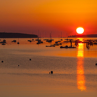
Frenchman Bay at sunset, Acadia National Park, Maine

The hotel is 10-minute drive from the town. We had the dinner at a Chinese restaurant, China Joy, on the main street. Their crab dish was quite good. My in-laws finally had some comfort food after several days. Bar Harbor is a small town. Most shops are along the main street. There are several restaurants by the bay serving famous Maine lobsters.

Bar Harbor at night, Acadia National Park, Maine
A store at Bar Harbor, Acadia National Park, Maine

After we returned to the I hotel, I asked with the front desk what is the best way to get to Cadillac Mountain the next morning. I was told that the government shutdown had just taken effect on the day. We had been on the road without following the news. It did happen. I later learnt that many visitors came from foreign countries to see America’s National Parks got so disappointed because all the parks were closed. Compared to them, we were still lucky.

I got up at 5am the next day morning. Much of Mt. Desert Island belongs to Acadia National Park, the rest is the private land. The roads that lead into the park were blocked, but visitors could still hike or bike into the park. It’s said that the summit of Cadillac Mountain sees the first sunrise of America, but there is another even more popular subject for photography in the park, Bass Harbor Lighthouse.

It took almost half an hour to reach the east side of the park. Before got into Seawall Rd. loop, I noticed a small Harbor on my left. Fishing boats dotted the tranquil harbor. Their reflections on the water contrasted perfectly against the backdrop of the horizon whose color had started getting warm. I got off the car and took some pictures.

Sunrise, Southwest Harbor, Acadia National Park, Maine

About 100 feet forward, two fellow photographers were also anxiously waiting for the sunrise and busy with their gears. I joined them for another set of pictures. We were blessed with wonderful settings, no cloud on the horizon but just enough cloud in the sky. In terms of pure sunrise in the good weather condition, this is the best I’ve every seen.

Sunrise, Southwest Harbor, Acadia National Park, Maine

I walked to lighthouse and checked around the area, then I returned to the Seawall Rd. and took some pictures by the coastline. Covered by the seaweed, the rocks are very slippy.

Seawall, Acadia National Park, Maine

I made several stops at Echo Lake by Maine 102. There was absolutely no wind. The lake surface was like a mirror. No wonder it’s called Echo Lake.

Echo Lake, Acadia National Park, Maine

After breakfast, I took my wife and in-laws into the park. We almost followed the same route as my morning excursion, but only diverted to Maine 198 South to the Upper and Lower Hadlock Pond. Unfortunately, it’s breezy when I brought them to the same spot at Echo Lake. It didn’t seem attractive any more.

Upper Hadlock Pond, Acadia National Park, Maine
Bass Harbor Lighthouse, Acadia National Park, Maine

Compared to Bar Harbor, Southwest Harbor is much less crowded. There are only a handful business here. We had lunch at Little Notch Bakery.

Southwest Harbor, Acadia National Park, Maine

We tried to get to Seal Cove area but got lost. On our way back, we stopped at the north shore of Somes Sound. Acadia National Park is famous for the broken coastline. Somes Sound carves deep into the island. It’s the only fjord on the US Atlantic Coast.

Somes Sound, Acadia National Park, Maine

Got some rest in the afternoon. We went to Bar Harbor again in the early evening. There is an interesting place at the end of Bridge Street. A gravel pass is exposed at low tide for a couple hours, so people can walk from here to Bar Island. We had walk half way to the island. It’s breezy, warm and relaxed.

Pass from Bar Harbor to Bar Island during low tide, Acadia National Park, Maine

The third day morning, I still got up early, but considering we’d drive to Boston, I decided not to shot the lighthouse in sunrise. Instead, I only went to the seashore near Bar Harbor and took some pictures of Acadia’s signature rocky coastline.

Sunrise, Near Bar Harbor, Acadia National Park, Maine

We checked out the hotel at 9am and were on our way to Boston. The fall color on I-95 were wonderful. I later learnt what we experienced was the best fall weather in 15 years.

Fall color on I-95, Maine

Our flight back to California was at late afternoon. We briefly stopped at Augusta, the state capital of Maine. It’s one of the smallest capital cities in America.

Maine State House, Augusta, Maine

We also made a break at Portsmouth. We had some coffee and did some shopping too. I had been here in 1997, 16 years ago, on the last day of the White Mountain trip with my classmates. Supposedly, I should have some sense of nostalgia, but I really had no memory of what the city had looked like.

North Church of Portsmouth, New Hampshire

As expected, the street to Boston was crowed and messy, but we managed to end our trip smoothly and leave us a lot of beautiful memory to recollect.

0 Comments