2014.5.24~26We decided to have a short excursion to the North Bay during the Memorial Weekend. Leaving home at 4pm, it’s almost 6pm when we got to Sonoma. Most shops had closed.


We had dinner at Della Santina’s. Although Yelp gives it 4-star rating, we found their food to be average.

The hotel we stayed, Embassy Suites at San Rafael, was only 30-minute drive away. The hotel is not luxury but spacious and comfortable. What surprised us is that this hotel features an in-door tropical garden and koi fish pond, very rare in hotels at this level; also the breakfast is included, very rare in hotels in American.

I got up early the second day morning. Driving from the hotel to the Golden Gate Bridge took only 15 minutes. I wished to capture the view of the bridge emerging from the early morning cloud. Unfortunately, it’s usual clear day along the coast. It’s only a little hazy but no cloud at all. I still drove along the Conzelman Rd. to the highest view point. This place is just so popular that there is no parking space any time during the day. However this time, it’s too early for normal visitors.

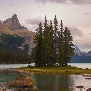
What I didn’t know was, the road doesn’t stop at Hawk Hill view point. A one-way road led me down hill to the other side of the peninsula. Just a turn away, the busy city and tourist site gives its way to the peaceful view of countryside. I drove towards Point Bonita Lighthouse and had a short walk to the lighthouse. I couldn’t get access to it because it’s not open on the day, but the view of the tip of the peninsula is quite unusual. I can’t believe this is so close to where we live. The shape of the hill made me feel like in a computer game.


Our plan for the day was to go to Point Reyes. We went there 10 years ago in the winter. This time we’d walk some trails. Followed the direction of Google Map, we took Lucas Valley Rd to the west. The cell phone soon lost signal once we got into the mountains. We made a turn at Nicasio Valley Rd. to the wrong direction, and landed at Sir Francis Drake Blvd. We took a brief stop at the church by the intersection.

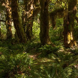
It’s about 11am when we reached Point Reyes Station. It’s sunny and warm. The Visitor Center’s parking lot were full. We first walked the Earthquake Trail, which is a half-mile loop. Bear Valley Trail is one of the most popular trails in Point Reyes. It starts at the visitor center and ends at the coast line of Drakes Bay. It’s about 9 miles round-trip. We walked about one mile down and returned.


Olema is along Route 1, only half a mile south to the visitor center. We had the lunch at the Farm House Restaurant.

After lunch, we drove along Pierce Point Road to the northern part of the park. We came here 10 years ago and saw a lot of Elks around the Tomales Point Trailhead. We didn’t see any this time. Maybe there were pushed to further north because there were so many visitors.
We walked down McClures Beach Trail to the beach. It’s windy but warm. The valley was covered by many wildflowers.


Returned to Tomales Point Trailhead, we started hiking to the north. Tomales Point Trail is about 10-mile round trip that leads to the Tomales Point. The trail of the first a couple of miles is almost flat and very easy to walk. The wildflowers are blooming along the trail. In terms of the size and variety of flowers, it’s not as good as Mt. Rainier, but close.


We walked about 1 mile and returned to our car. It took about 1 hour to get back to the hotel. Only 20 minutes away from San Francisco, we wanted to have dinner at a good Chinese restaurant in the city. Chili House seemed to be a good option. They claim the chef has served two Chinese presidents. We waited until 8:30pm to avoid traffic and crowd. The food is OK, we were not super impressed, but the good thing is they were not too salty.

The last day morning, after checking out of the hotel, we drove over to China Camp State Park. The park is located at San Rafael. It offers both hill side hiking options and open view of San Rafael Bay.


Driving south on 101 for 5 miles, we took another diversion to exit at Tiburon Blvd. (Route 131) towards the bay. Town of Tiburon is directly facing Sausalito across Richardson Bay. There is a long boardwalk along the coastline. The view of the bay and the Golden Gate Bridge was wonderful. We have never been to Tiburon before but it could very much be our next excursion destination.