The Last Place on Earth – Tierra del Fuego NP

2012.1.6I booked a tour to see Tierre del Fuego National Park on our second day at Ushuaia. Knowing that the scenery is not as dramatic as TDP, my wife preferred staying in in the city to do more shopping.

The guide met me at hotel at 8:30am, then he went around the city to pick up a family from Australia and two Argentines. Our first stop at the park was a railway station. Besides offering a steam locomotive tour, the station has a major theme of its prison history. The city of Ushuaia was first created mainly as a prison because of its remote location. At the first half of the 20th century, Argentine government expanded the town around the prison to increase its population and to enforce Argentine sovereignty at Tierre del Fuego. This is why posters and paints of prisoners can be seen everywhere in Ushuaia.

End of The World Train, Tierra del Fuego N. P.
The ‘End of the World’ train
Southern Fuegian Railway Station, Tierra del Fuego N. P.
Southern Fuegian Railway Station
Southern Fuegian Railway Station, Tierra del Fuego N. P.
Southern Fuegian Railway Station

All of us were more interested in natural beauty so we skipped the locomotive tour and directly went into the park. The next stop was Ensenada Bay, we had a short walk on the coast of the Beagle Channel and the surrounding hills.

Ensenada Bay, Tierra del Fuego
Overlook the Beagle Channel at Ensenada Bay
Around Ensenada Bay, Tierra del Fuego
Forrest around Ensenada Bay

The tour took us to the Roca Lake. It’s located at the border between Argentina and Chile and offers one of the most beautiful views in the park. We walked along the lake to the visitor center. I got an opportunity to shot a group of Black-necked Swan.

Roca Lake, Tierra del Fuego N. P.
Roca Lake
Roca Lake, Tierra del Fuego N. P.
Roca Lake
Roca Lake, Tierra del Fuego N. P.
Black-necked swans at the Roca Lake

Driving south, we made a brief stop at Green Lagoon to overlook the lake in the turquoise color and the trees damaged by the beavers.

Green Lagoon, Tierra del Fuego N. P.
Green Lagoon

The highlight and the final stop of the tour was Bahia Lapataia. The guide stopped the car at a trail head and let us walk over the hill. The trail leads to a parking lot that marks the end of National Route 3. This is the most southern end as far as the road runs.

Lapataia Bay, Tierra del Fuego N. P.
Lapataia Bay
The end of the Panamerican Highway, Tierra del Fuego N. P.
The end of the Panamerican Highway at Lapataia Bay

We bumped into our co-passengers of the Antarctic cruise from time to time on the street of Ushuaia and we met many of them at the airport. It’s an interesting feeling that we came from all over the world, spent several days together in such a surreal place and now we would return to whoever we are. At the check-in counter, Aerolineas Argentinas told us the flight “is ONLY delayed by 50 minutes”. We would arrive in Buenos Aires at the midnight.

Ushuaia Airport
The plane was ready to take off from Ushuaia Airport at 9pm.
0 Comments

The Last Place on Earth – Ushuaia

2012.1.5In the morning at 7am, the ship reached the pier in Ushuaia. Our journey in the Antarctic came to the end. We would spend the rest several days in Argentina.

Ushuaia Port
Pier of Ushuaia

We checked into Alto Andino Hotel. It’s a little bit off the main road, small but very well built. It’s still too early to get a room, so we left our luggage at the hotel and walked to the city center. Ushuaia is the capital of Tierra del Fuego Province and often regarded as the southernmost city in the world. However, compared with Punta Arenas, which is a fully diversified city, Ushuaia’s main function is the gateway for researchers and tourists to explore the Southern Ocean.

Ushuaia
Overlook Ushuaia from Alto Andino Hotel
Ushuaia Signpost
Signpost on San Martin St.

Ushuaia really has only one main street, San Martin. At one end of the street, there is a Chinese restaurant, Arco Iris (Rainbow) restaurant. The owner came down from Buenos Aires to manage the restaurant by herself. They run a good lunch buffet and also offer traditional Argentine BBQ. However, we asked the chef to make a special order of tomato soup noodle. It was HUGE. After eating western dishes for more than a week, we finally had a real Chinese comfort food at the world end.

Arco Iris restaurant
Rainbow Restaurant

There were many booths around the port selling cruise tours to the Antarctic region. The lowest price of the similar tour like ours was $3500. Only the backpacker can take advantage of this low rate. We stopped at several museums and Souvenir stores, but for the most of the day, we just took time and rested at the hotel room.

Ushuaia Street Drawing
Street drawing on San Martin St.
Ushuaia Street Drawing
Street drawing on San Martin St.
Ushuaia Street Drawing
Street drawing on San Martin St.

Ushuaia is famous for its spider crab dishes. Living in the cold water in Beagle Channel, Spider Crab is a similar species to Alaska King Crab. We had the dinner at La Cantina Fueguina de Freddy on San Martin. The crab was fresh and tasty, but we are still in favor the dishes at Brocolino in Punta Arenas.

La Cantina Fueguina de Freddy
Restaurant La Cantina Fueguina de Freddy
La Cantina Fueguina de Freddy
Crab dishes at Restaurant La Cantina Fueguina de Freddy
0 Comments

The Last Place on Earth – Drake Passage

2012/1/3 ~ 4Roaring forties, furious fifties and screaming sixties are the names given by the sailors to the strong westerly winds found in the Southern Hemisphere. Drake Passage, notorious for its rough, often violent, sea, spans between the latitudes of 50 and 60 degrees. We will take two days to cross it.

Drake Passage is about 500 miles wide. It’s estimated that the passage was opened around 20 to 40 million years ago. This ‘event’ not only isolated Antarctica from other continents, but also made the unimpeded flow, Antarctic Circumpolar Current, possible. The current keeps the warm water away from Antarctica and further cools down the continent. Many researchers believe it is a major factor of the glaciation of Antarctica. Where the warm and cold water meet, named Antarctic Convergence or Polar Front, sees a sharp change of the surface water’s temperature and forms a significant biological boundary. As the cold water sink, upwelling of deep water bring substantial amount of nutrients and nurtures abundant Krill, which results in food chains supporting fish, whales, seals, seabirds and other species.

The Captain
The Captain watching the sea while navigating the ship

The first day on the Drake was quiet and eventless. The whole day was dedicated to lectures. In the morning, Jolande spoke about the Race to the Pole, the competition between Scott and Amundsen to be the first to reach the South Pole. I learned their stories when I was in the middle school; sailing at the Antarctic and listening to their heroic story, I couldn’t help felting inspired again. I believe a lot of people felt the same way, because the whole lecture room was filled by the passengers. After Jolande’s lecture, Lex talked about the whales and dolphins of the area where we had been sailing. After lunch, Jolande gave another talk about the general introduction to Antarctica, including both its geographic features and political status.

The sea was smooth, we were visited only by some Cape Petrels. Petrel and Albatross spend most of their life in flight. Once they grow up, the often fly for several years without returning to the land. Gliding is the most energy-efficient for them to cover the long distance to locate patchy food sources. In fact, their wings are so adapted to glide, when the sea is calm, they are forced to rest on the ocean’s surface and wait for the wind to pick up. We saw this happen several times with these Cape Petrels.

Cape Petrels
Cape Petrels resting on the sea
Cape Petrels
Cape Petrels

The second days saw a totally different weather. The wind was getting stronger and the sea was rough. Only a few people showed up in Jolande’s presentation on the life of Edward Wilson. He was a naturalist and artist who went to the South Pole and lost his life together with Captain Scott. Although the lecture room is at the bottom of the ship, we couldn’t stay in our seats because of the rolling sea. Even for me who were never too sensitive to anything started feeling uncomfortable for a while. Lying on the bed soon calmed me down, then I was literally thrown out of the bed by a huge wave.

Huge Waves in Drake Passage
Huge waves in Drake Passage

The wind speed reached 60 knots. Not everyone made to the breakfast and lunch. We had to take care of our forks and plates, otherwise, they might fly off the table. One French girl was pushed to the floor and the chain to secure the chair to the floor got broken. The afternoon lecture was cancelled, instead, the film “Around Cape Horn” was shown in the library. The following are two videos I shot on the rough sea. It’s Lex who was making announcement about the film in the first video.

It was foggy outside. We sailed past Cape Horn without actually seeing it. At the afternoon, the wind was still strong but as we closed to the land, Tierra del Fuego, the waves slowed down. We settled our bills on the ship, returned boots and parkas and got our passports back with stamps of Antarctica. Every passengers received an Antarctic Dream’s jacket and a certificate reads,

We hereby certify that while travelling aboard the M/V Antarctic Dream,

XXXX XXXX

has set foot on the Antarctic continent, just as the original explorers that came before him/here. This event took place on,

Brown Bluff 30-12-2011
Neko Harbour 31-12-2011

Captain: Ernesto Barria Expedition Leader: Stefan Kindberg

After dinner, we had a farewell cocktail party. Stefan urged us to come back and revisit this fascinating continent in the future; then, he held an auction of the captain signed navigation chart of this voyage. After a heated bidding war, the Russian family living in the most expensive suite eventually beat the Spanish family living in the second most expensive suite at $2100.

The sun returned by the late afternoon, I finally saw a sunset after several days. We’ve reached Beagle Channel. The captain stopped the engine. We would wait there until the next day morning to get to the port of Ushuaia.

Beagle Channel
Sunset over Beagle Channel
Beagle Channel
Sunset over Beagle Channel
0 Comments

The Last Place on Earth – Deception Island

2012.1.2We got a very early wake up call this morning. By 5am, we were approaching Deception Island.

Day 4 Route
The navigation route of the fouth day

Deception Island is the caldera of an active volcano. It is called Deception Island because, looking from the outside, it just appears to be a normal island; but it has a narrow opening that leads to the inner water, the island is actually a ring. The narrow opening is called Neptune’s Bellows, which is only 230 meters wide. The wind was strong. It took a bit of caution to navigate through.

Neptune's Bellows, Deception Island
Neptune’s Bellows

Our landing spot is at Whalers Bay. Up the hill is called Neptune’s Window. It is a gap in the volcano rim. It’s about 100-meter high and most of us walked up and had a look of the outside of the caldera. Some Cape Petrels with their chicks nested on the cliff.

Neptune's Window at Whalers Bay, Deception Island
Walking up to Neptune’s Window
Look out from Neptune's Window, Deception Island
Look out from Neptune’s Window. A small beach outside of the caldera.

Deception Island has several Chinstrap Penguin colonies. As we walked down from the hill, several of them just swam back to the beach from the sea. With a black band under their heads, they are by far the most cute-looking penguin we’ve seen.

Chinstrap Penguins, Deception Island
Chinstrap Penguins on the beach
Chinstrap Penguins, Deception Island
Chinstrap Penguins on the beach
Strange creature on the beach, Deception Island
Some strange sea creature found by Lex on the beach

Further down on the beach, it’s the remnants of the old whaling station. The station was closed in 1930s’ as the supply of whales was almost exhausted. A serials of volcano eruptions in 1960s’ destroyed most of the station. Now a day, Deception Island has become a popular landing site of the Antarctic cruise. One of the activities is to make a warm bath by digging into the sands. In a better day, some water temperature can be very hot near volcanic area. It was a cold and gloomy day with a cutting wind, but there were still a few brave ones dare to dashing into the sea.

Gloomy weather at Deception Island
It’s a gloomy and foggy day. The wind is cold.
Whaling Station, Deception Island
The remnants of old whaling station.
Whaling Station, Deception Island
Some visitors prepared to jump into the sea.

We went back to the ship at 8am. After the breakfast, Lex gave us a presentation about the history of the whaling industry. Blue Whales were abundant in nearly all the oceans on Earth until the beginning of the twentieth century. Especially in the Antarctic region, at the time of 1966, when whale hunting was banned, the number of Blue Whales has been reduced to 10% of its original population in 1900. Without the industry killing so many whales before the ban, whale watching wouldn’t be a tourist program as whales would be much easier to be seen in the sea.

After the lecture, most people went back to the room to get some rest. A Northern Giant Petrel followed our ship very closely. The way to distinguish it from the Southern Giant Petrel is that it has a red bill, while the Southern one is in green. Only people in the dinner room got chance to see it. Against the wind, gliding through the snow, sometimes it flew high above the ship, sometimes almost touched the wave. Its wings spanned 2 meters and never flapped. Watching it fly, I saw calm and determination.

Northern Giant Petrel
Northern Giant Petrel was following the ship and gliding.

After lunch, Stefan and the captain decided that our second planned landing of the day, Fort Point, had to be cancelled because of the weather condition. The wind is strong around the coast of Greenwich Island in the South Shetland Islands. Lex gave another talk about the seabirds of the Drake Passage. He is an active supporter of the Save The Albatross campaign. By the dinner time, we sailed into the Drake. We were now out in the open sea.

1 Comment

The Last Place on Earth – The Southernmost Post Office

2012.1.1“Good morning! Good morning! Good morning!”. This is the third time that Stefan woke us up in the trip.

Day 3 Route
The navigation route of the third day

It’s 6am. Although it’s still quite cloudy at where we were, at the horizon where the mountains pierced through the cloud, we could already see the blue sky. We were sailing towards Lemaire Channel. Suddenly, the ship shook with clashing sound. “Did we hit the iceberg?” Yes, we did, but small ones. Disc-shaped ice floes covered the sea as far as the eye could see. With the strengthened hull, the ship crashed through the pack ice.

Lemaire Channel, Antarctica

At 7am, we sailed into the Lemaire Channel. The channel is about seven miles long and one mile wide. We had not seen the blue sky for 3 days but we were so lucky that we had a beautify day when we were sailing at the most beautify route of our voyage. No one on the deck made any sound. We just watched these breathtaking mountains and their reflections over the tranquil sea gliding through our eyes.

Lemaire Channel, Antarctica

Our first intended landing site was Peterman Island, this would be our southernmost landing site of the trip, and the southernmost Gentoo Penguin colony. However, after we sailed out the Lemaire Channel, the Captain and Stefan decided to turn around because there were too much ice in the sea and it’s very unlikely we could reach the islands. As the ship was making the turn, we spotted a Leopard Seal at starboard. We got a quite good look at it but the seal was not impressed by the ship. It looked up, turned and went back to sleep. Don’t be fooled by its innocent look and lazy moves, Leopard Seals are the top predators in the Antarctic water.

A Leopard Seal at Lemaire Channel, Antarctica

We arrived at our next landing site before lunch. Port Lockroy small harbour that was used as whaling station after it was discovered in 1904 and later used as a military base for British government during WWII. The station was renovated and converted to a museum by the United Kingdom in 1996.

Port Lockroy, Antarctica

Volunteers from UK come here and spend the summer in the station. At the time we visited the harbour, there were 4 ladies living in the station. Our zodiac took them to the ship and had a lunch with us. We were all very curious about what they do for their everyday lives. In fact, telegraph is the only way for them to communicate with the outer world, no radio, let alone TV. There is no running water and no boat for them to even reach the nearest island, so they must melt snow and reserve water. The only chance they can have a shower is to get on the tourist ship like ours. I guess during the summer time, tourist ships visit the harbour quite often so at least they can have decent meals occasionally. When asked why she chose this job, the lady at our table answered, “I wish to make some deference.” I don’t know how much this is from her heart and how much it is because of the politically correctness, but it is a respectful task she is taking as an individual.

Port Lockroy, Antarctica

After lunch, we were first taken over to Jougla Point to see some Gentoo Penguins and Blue-eyed Shags – their backs are also in black and underparts are white, look quite similar to Penguins. The beach has a reconstructed whale skeleton and offers a perfect view of the harbour and surrounding mountains.

Port Lockroy, Antarctica
A Gentoo Penguin, Port Lockroy, Antarctica
Blue-eyed Shags, Port Lockroy, Antarctica
Blue-eyed Shags, Port Lockroy
The Whale Skeleton on the beach of Jougla Point, Port Lockroy, Antarctica

From Jougla Point, the zodiacs took us to Goudier Island, where the British base is operated. Besides a museum and a souvenirs store, the base also has a post office in operation. Many people bought, wrote and posts cards from the southernmost post office of the world. The sun was shining. It’s a gorgeous day.

The Southernmost Post Office, Port Lockroy, Antarctica
Visitors writing post cards at Port Lockroy’s post office.
The British base at Port Lockroy, Antarctica
The room that was used by original British base at Port Lockroy.
The British base at Port Lockroy, Antarctica
Port Lockroy, Antarctica

We left Port Lockroy at 4pm and sailed north through Neumayer Channel and then entered Gerlache Strait for our next destination, Deception Island.

Mountain Range around Gerlache Strait, Antarctica
Mountain range around Gerlache Strait
0 Comments

The Last Place on Earth – An Evening Climb

2011.12.31The next day morning, we have cruised around Trinity Peninsula, the northern tip of the Antarctic Peninsula, and we were sailing south in Gerlache Strait.

Day 2 Route
The navigation route of the second day

The heavy cloud that took the sky for two days now opened up a bit. The mountain range at the continental side looked mysteriously beautiful.

Mountain range in Antarctica

At the breakfast time, there were two Humpback Whales appearing at the right side of the ship. Many of us rushed to the deck to watch them. The captain turned off the engine and tried to stay close to them. Their surface lasted for 10 minutes. They didn’t jump but at least we saw their tails several times.

Humpback Whales, Antarctica

Morning time was devoted two lectures. Jolande talked about different penguin species and their behaviors, and Lex gave a talk about seals of the Antarctic.

Icebergs, Antarctica

We had our first landing of the day at Cuverville Island after lunch. This is a small island that hosts the largest Gentoo Penguin colony in the peninsula. As we have sailed south more, the weather were getting warm later than the place we visited the previous day. There were no chicks on the island – they were still on the eggs. However, it was a very warm day. I took off my parka, left it on the shore and wander around the island with just a fleece.

Gentoo Penguins, Cuverville Island
A Gentoo Penguin, Cuverville Island
Gentoo Penguins, Cuverville Island

An interesting phenomenon we found was penguins’ highway system. It’s very difficult for penguins to walk on the soft snow. Sometimes, it’s actually dangerous. Our guides told us not to walk on the untouched snow because our boots could make deep poles. If a smaller penguin fall into the pole, it’s almost impossible to get out. We could see these tracks that stretched from the beach to the hill and there were some parallel ones across the hill as well. Penguins use them to get up to the hill faster and safer.

Gentoo Penguins and their highway system, Cuverville Island

Cuverville Island is at the entrance of the Errera Channel. On our zodiac ride back to the ship, we had a detour to cruise through the maze of icebergs in the channel. Back on board, as we kept sailing south, we saw several more whales at afar.

Icebergs, Cuverville Island

Dinner was early today because we would have the second landing after the dinner. The place is called Neko Harbour. It’s another continental landing. At one side of the harbour is Rupert Glacier. After we landed on the pebble beach, our expedition leader, Stefan, told us if we heard loud cracking sound, “don’t stay at the beach, run to the higher land”. We did see some calvings of the glacier, but they were all small pieces.

Rupert Glacier, Neko Harbour

There were some Gentoo Penguin on the beach, but we just passed them by and started climbing the hill. After half an hour, most of people had reached a huge boulder at the hillside. Lex asked everyone to keep quiet for 3 minutes, no talking, no photo shooting, just listen to the nature surrounded us. View the harbour from the top, we were immersed in the sound of silence.

An evening climb, Neko Harbour
At the hillside, Neko Harbour
View Neko Harbour from the top

At 9:30pm, we started walking back. The hill was covered by knee-deep snow. We could totally indulge ourselves, running, sliding or rolling down the hill. (Penguins don’t come to the slope). At the beach, there was a Weddell Seal hauled out on the far side.

A Weddell Seal on the beach, Neko Harbour
A Weddell Seal on the beach

We returned to the ship at 10pm. It is the last day of 2011. The crew hosted a celebration party and we counted down the new year.

0 Comments

The Last Place on Earth – The First Landing

2011.12.30When I got up on the next day morning at 6:30am, we were stilling sailing through the Antarctic Sound.

Day 1 Route
The navigation route of the first day

There were many icebergs in this region but not extremely huge in size. Penguins stood on top of the flat ice and jumped out of the sea from time to time.

Iceberge at Antarctic Sound
the Antarctic Sound in the morning
Adélies jump out of the sea
Penguins jumping out of the sea

Our first landing would take place at Paulet Island. It has a very large Adélie penguin colony, 100,000 pairs, living on the island. As we were close to the island, we got our first scent of the massive Adelie colony. They smelled awful! When the ship finally stopped and we had a clearer view of the island, I couldn’t believe my eyes. Paulet Island is a young volcano. I thought I saw the the rocky surface from afar. However, they were not rocks – they are penguins, stretching from the beach to 100 meter up to the hill and covers almost entire volcanic cone.

Adélie penguins standing on the flat ice, near Paulet Island

This was our first landing. At 8am, everyone dressed up and couldn’t wait to get on to the zodiacs. The first boat departed with just guides. After they located the best landing site, they gave the green light to the rest of zodiacs to go. Every zodiac can carry 10 passengers each time. With 3 zodiacs in use, it took less than 15 minutes to take all our 60 passengers to the beach.

Adélie Penguins, Paulet Island
Huge Adélie penguin colony on Paulet Island

Once on the island, we were surrounded by Adelie penguins. The beach was quite busy, as penguins coming and going from the sea. Adélie penguins can be recognized by the white ring surrounding their eyes. With the black back and white belly, they fit the best to the image that people think of penguins, like wearing the tuxedo.

Adélie Penguins, Paulet Island
Adélie penguin, Paulet Island
Adélie Penguins, Paulet Island
Penguins often move in a group, Paulet Island

Many penguins had their baby chicks, carefully guarded under the parent’s belly. Most of them had two chicks, sometimes there was only one with another egg unhatched. The guide told us, for many of them, only one chick could eventually survive because the parents couldn’t feed both of them in the harsh weather condition. The chicks’ feather are in gray color. They have to grow fast in the short summer. When they are in the nest with the parent, all they do is to ask for more food constantly.

Adélie Penguins, Paulet Island
An Adélie penguin feeding its chicks

On the path to the inner island, there was a ruin of a stone hut. The hut was built in February of 1903 by survivors of the Swedish South Polar Expedition led by Otto Nordenskjöld. Past the hut, we saw a little lake. Some penguins slide on the ice cap. This is an easier and faster way for them to move around. We walked around the penguin colony. Their poops were everywhere, especially around their nests. The fish eating penguins leave behind white guano, while those eating krill excrete pink quano. Most of the ground were covered in pink to red color.

Adélie Penguins, Paulet Island
Adélie penguins slide on the ice

Like all penguins, the Adélie is highly social, they often go out to the sea in groups. They are also very aggressive, when other penguins try to steal stones from their nest, fights often arise.

Adélie Penguins, Paulet Island
Adélie peguins, Paulet Island
Adélie Penguins Fight, Paulet Island
Adélie peguins in fight, Paulet Island

We returned to the ship at 11am. Across the Antarctic Sound, at 2pm, we arrived at Brown Bluff. The name comes from brown volcanic rocks and steep slopes of the island. Located on the east coast of Tabarin Peninsula, Brown Bluff was our first continental landing. We would step onto the real Antarctica.

Brown Bluff
Brown Bluff

The island is colonized by both Gentoo and Adélie penguins. Once we were on the beach, we immediately saw several Gentoo penguins with their chicks nested around some rocks. Gentoo penguins are easy to recognize for the red beak and white strip on top of the head. Some of chicks were already 3 to 4 weeks old, some were still quite young. They were fat and lively, just like Adélie chicks, kept asking for more food.

Gentoo Penguins, Brown Bluff
A Gentoo penguin with its almost grown-up chick
Gentoo Penguins, Brown Bluff
Gentoo penguin feeding the chicks, Brown Bluff

Walked further down the beach, we reached the border of Adélie penguin colony. They too had many chicks, some of them were big enough and had their own down jacket so that they no longer need to be taken care by their parents. Instead, they gathered in crèches (day care) and only need to be guarded by a few adult penguins.

Adélie Penguins, Brown Bluff
Adélie penguins, Brown Bluff
Adélie Penguins, Brown Bluff
Adélie penguins, Brown Bluff
Adélie Penguins' crèche, Brown Bluff
Adélie penguins’ day care center, Brown Bluff

It’s snowy and foggy, the worst weather we had in Antarctica. Soon, the wind picked up. It’s katabatics, or fall winds, formed by the cold air from the inland and accelerating as it drops from the high elevation to the coast. We were asked to return to the landing zone and hang on tight while on the zodiacs.

Adélie penguins heading to the sea, Brown Bluff
A column of Adélies heading to the sea, Brown Bluff

The sea became choppy. We left Brown Bluff and sailed back through the Antarctic Sound. This time, we saw many huge icebergs in tabular form. Some of them were 50-meter high and 1000-meter long. During the dinner, our guide recapped today’s activities. Jolande also told the story of Nordenskjöld and captain Larsen‘s expedition around the region that we visited today.

Icebergs, the Antarctic Sound
0 Comments

The Last Place on Earth – Fly to Antarctica

2011.12.29We were told to be at the hotel lobby at 6:30am and wait for pickup. When we were there, there were more than 20 people waiting in the lobby. Some of them had already put jackets and mountaineering boots on. They made us feel so under-prepared. The bus arrived on time and we went around the city to pick up more travelers. We were dropped at Punta Arenas airport at 7:15am. Surprisingly, we saw the flights to Antarctica were also listed on the departure board.

Flight to Antarctica
Flights to Antarctica on the departure board at Punta Arenas Airport.

We turned our passports in to the tour organizer. When we come back from Antarctica, we would be at the Argentina side. The tour company would help us pass the immigration check. While waiting to be checked in, we realized that those who were wearing professional gears are not part of our tour group. After one hour, we met them again in the waiting room. They belong to 7-Summits Club. The ultimate goal of the club members is to conquer seven highest mountains of each continent. There target this time was Vinson Massif, 4,892 meter high, in the middle between the Antarctic Peninsula and the south pole. They would be directly taken into the inland and dropped on the white continent. That is why they had put already their gears on. Compared with these people, we were really just tourists.

Mountaineering Boots
The mountaineering boots of 7-Summits Club members,

Tourists were excited when it’s their turn to board the airplane. It’s a little windy, but much less than the earlier day.

Airplane to Antarctica
Boarding the airplane to Antarctica.

The plane took off at 10:30am. All the flight attendants were male. It was very cloudy but no storm. Sitting almost at the very end of the plane, we felt the flight was very smooth. The service was good and we had a lunch on the flight. After two and half hours, we landed at King George Island. It’s said that this is the most polluted antarctic island. Many countries have their antarctic station here.

King George Island
View the King George Island from above.

It was freezingly cold and snowing a little when we got off the plane. In fact, it might be the coldest day we had in Antarctica. Everyone tried to put on whatever they could find, jackets, hats, neck warmers. It was somewhat chaotic until our guides came. We left out the luggage on a plastic sheet, they would be delivered to the ship by carts, and started walking to the shore. The walk was about 1 mile, in between the Chilean Frei Station and Russian Bellingshausen.

Walking to the Shore, King George Island
Walk towards Fildes Bay of King George Island.
Russian Bellingshausen and the Trinity Church
Russian Bellingshausen station and Trinity Church, an Orthodox church is permanently manned by a priest.

We had our first Penguin encounter close to the shore. They are Gentoos and Chinstraps.

Gentoo Penguins at King George Island
Gentoo penguins near Chilean Frei Station.
Chinstrap Penguins at King George Island
Chinstrap penguins at the shore.

Zodiacs took us to the ship at 2pm. This was our first zodiac ride. The guides gave us a crash course of how to get on and off the zodiac. At the ship, we were welcomed by teas and soups that helped us warmed up. All the passengers were assigned to their room. We had a “Shackleton Cabin”, which has its private bathroom, two twin beds and best of all, a nice window for the view.

Zodiac Operator
Zodiacs were waiting us on the beach.
Zodiac to the Ship
Get onto the ship from the zodiac through the gangway.

At 4:30pm, all the passengers went to the dinning room for the mandatory safety drill. The officer meet us there and took us too the deck and explained to us what to do in case of an emergency. One hours later, we had another mandatory meeting at the lecture room at the bottom of the ship. Lex, one of our guides, talked about the code of conduct for Antarctica, for example, how to behave around the animals. We were issued boots and parkas so we were ready to land in Antarctica.

Safety Drill
The first officer explained the safety rules. Lex, on this left, acted as a translator for him.

At 7:30pm, we had our first dinner on the ship and met all the guides and staff. The captain welcomed us to the ship and the Antarctic in English and Spanish.

The Captain Welcomed us on Board
The captain welcomed us on board at the dinner.

The ship was cruising south towards Antarctic Sound and Weddell Sea. Antarctic Sound is often called as the channel of icebergs. At about 10pm, icebergs started appearing in our sight. At the year end, it’s almost the longest day in the southern hemisphere. The sun sets at 2am and rises at 5am. It’s a regret that I never stayed long enough to see the sunset in our whole trip.

Iceberge at Antarctic Sound
The black points on the iceberg are penguins.
0 Comments

The Last Place on Earth – Torres del Paine

2011.12.28Unpaved roads only allow cars to access a small section of Torres del Paine National Park. Separated by lakes and rivers, the majority of the park can only be reached by hiking trails. The famous TDP Circuit is 100 miles long and usually takes 7~10 days to finish. It is often considered as one of the best hiking trails in the world. The shorter and less demanding alternative, the W trail, requires about 4 days. My original plan was to see the Glacier Grey on the day of our arriving and hike a couple of hours on the second day. However, as we wasted our first day with our vehicle, we wanted to cover as much as we could by car on the only day we would spend in the park.

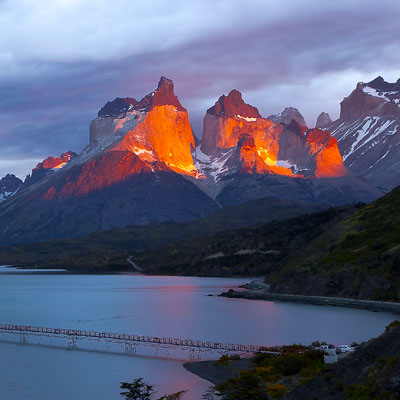
To catch the sunrise, I got up at 5am and went to the vista point that overlooks Lago Pehoé. Unfortunately, thick cloud covered the entire sky. The lake and the mountains were all casted in a cold blue tone. I waited for 20 minutes and the cloud showed no sign to retreat. Distracted by the bushes and thick vegetation, I pointed my camera to the ground. For no reason, I raised my head and I was astonished by what I saw. The cloud opened up a thin line that allowed the sunshine piercing through the leaden sky. The stripe of light projected onto the mountain in a bright red color. Hurry to grab my tripod, I actually pushed it down and my camera hit the ground. I had to clean my lens before I could take any picture. The light lasted less than 5 minutes and I only manged to make two shots. As a photographer, it’s a great pity to be at the right place at the right time but not being totally ready. Nevertheless, it’s the most glorious sunrise that I’ve ever watched. The pictures can never capture the excitement I experienced at the moment.

Sunrise over Lago Pehoé
Sunrise over Lago Pehoé. In terms of photography, the setting was not ideal because most of the areas are too dark; but to the one who viewed the color transition at the very moment, it’s glorious!

There is a full facility camping ground 2 miles down the road. It costs only $6 per night. I went there to take several pictures of the lake from a different angel.

Lago Pehoé and Cuernos del Paine
View Lago Pehoé and Cuernos del Paine from camp Pehoé.

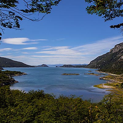
I drove back to the hotel and went to bed with the concern that if we would have a clear day. After several hours, when I stepped out of the room again, wind had blow the cloud, as well as my worry, away. Lake Pehoé revealed itself in turquoise color, similar to the glacier lakes in Banff, under the blue sky.

Cuernos del Paine
Lago Pehoé in turquoise color.

After the breakfast, we started driving to the north. The first stop is the port of Lago Pehoé. At the time we arrived there, a boat was just about to set off. A lot of hikers were ready to get on board. In the summer, there are 3 shifts of cruise boat (Catamaran) to take hikers crossing Lago Pehoé. It is one of major entry points to start TDP Circuit trek.

Salto Grande Fall
Salto Grande, a waterfall that connects Lago Nordenskjöld and Lago Pehoé.

We parked the car and started walk a trail towards Sendero Mirador Cuernos – a view point that overlooks Cuernos Principal across Lago Nordenskjöld. Cuernos means Horns, which is a vivid description of the shape of TDP’s most famous peak. The trail made a turn to the north, we now had a open view of Cuernos Principal. From here, we could walk to the waterfall, Salto Grande, that we saw earlier. The wind suddenly got much stronger, we could hardly stand still on the open field.

Stormy Weather of Cuernos del Paine
Stormy weather over Cuernos del Paine.
Salto Grande Fall
Salto Grande Fall.

We decided to turn back and continued driving to northeast side of the park. At one point, we saw a group of guanacos. They are the close relatives to Llamas and Alpacas we saw in Peru. I knew them from the comic book, The Adventures of Tintin, as they spit on Captain Haddock several times – it is their nature to spit when threatened. Looked very vigilant, they were not afraid of people in close distance. We took many pictures with them.

Guanacos
Guanacos

Cuernos del Paine and Monte Almirante Nieto are the dominant existence of the TDP National Park. They were never out of our sight as we kept driving. Although we planed to reach Hotel Las Torres, which is the starting point of the challenging 9-hour must-do hiking trail to Base Las Torres peak, we actually only drove half way there. The unpaved road were too bumpy and annoyed us a lot. A 4-wheel drive jeep passed us like wind. That’s the car I will rent next time.

Cuernos del Paine and Monte Almirante Nieto
Cuernos del Paine and Monte Almirante Nieto.

We returned the hotel at 2:30pm, had a lunch and took some rest for a hour, then started off to Lago Grey. Again, we didn’t go very far after we reached the park’s administration where we found the polices the earlier day. The road was too bumpy, the wind was strong and we also worried about if our gas was enough to return Puerto Natales. On our way back, we made a stop at Hotel Salto Chico. This is a hotel at the price of $7000 for 4 nights, even more expensive than Sanctuary Lodge at Machu Picchu. It was hot and dry half an hour ago, but now it started raining. We walked around the hotel to see another waterfall, Salto Chico, that the hotel is named after. The wooden plank road took us to the view point behind the hotel, but with the gusty wind blowing the freezing rain against us, I felt the platform was not very safe, not as nice as the open-air jacuzzi that some residents were enjoying.

Around Hotel Salto Chico
The meadow field under the strong wind around Hotel Salto Chico.

Patagonia’s weather is capricious to say the least, 10 minutes later and several miles away, when we returned to our hotel, the rain stopped and the sky was getting clear again. It’s 6:30pm now. We decided not to go anywhere but rest at the hotel. Although we were not able to do many things we originally planned, after all this was only an overture of a grander journey.

Hosteria Pehoé
Hosteria Pehoé.
Hosteria Pehoé
Overlook Lago Pehoé and Cuernos del Paine from Hosteria Pehoé.

We checked out of hotel at 9am the next day. When we reached Puerto Natales, the gas tank was still half full. The returning trip was uneventful except a couple of herds of cows and sheep we encountered, for the rest of the time, the strong west wind was our only companion.

Cloud in Strange Shape
Cloud in strange shape in TDP national park.
Cattle Herd
Cattle head blocked the road.
Unpaved Bumpy Road to TDP
80 miles of bumpy, and painful, dirt road from Puerto Natales to TDP.

It’s 2pm when we saw the Strait of Magellan again. The wind was continuously blustering and has become more and more violent. Although fierce wind is very common in the westerlies region, even local people admitted that this was unusual in the summer. It was said the wind speed reached 50 mph (level 9). We got in touch with the tour organizers of Antarctic Dream. They told us that most likely the next day’s flight wouldn’t be affected because “they have done that before”, but that didn’t really ease our worries.

A couple of hours later, mother nature revealed her power again – magically, the wind stopped completely. We walked to the restaurant La Marmita to have the dinner. This is Punta Arenas‘ No. 1 restaurant recommended by TripAdvior users. The decors and settings were nice, but the taste was at the plain side. Looking thought the window, the smallest branches of the tree didn’t move at all. We saw it as a bless to our journey the next day.

Restaurant La Marmita
Restaurant La Marmita.
Restaurant La Marmita
Restaurant La Marmita.
1 Comment