From Santa Cruz Island to Isabela and Fernandina islands, we had to sail out of the area surrounded by the archipelago to the outer sea, where the wind and waves are stronger. Our boat was much smaller than the one in Antarctica, so it felt very bumpy on the rough water. Fortunately, we took anti-seasickness medication first and slept through the night.
The next morning we woke up to calm seas and the yacht was anchored on the west side of Isabela Island. Our yacht has four levels, with the crew cabins, galley and machinery room at the bottom. Visitors live on the first level, which is also the main public area and dining room. The second level is the cockpit, high-end guest rooms and open space where meals can be served when the sea is calm. The top floor is the observation deck with sofas and loungers.
Seaman Jouney
Seaman Jouney upper deck
Isabela Island is the largest island in the archipelago, shaped like a seahorse, formed by six volcanic eruptions that connect the land. Five of the six volcanoes are active, including Sierra Negra, the largest of all the Galapagos Islands volcanoes, with a crater nine kilometers in diameter. It was actually erupting while we were there, but it would take a few days more before the lava would spew out. Isabela has permanent residents, mostly in Puerto Villamil on the south coast, and land-based visitors often stay overnight in Puerto Villamil to participate in the island’s various activities, including climbing of Sierra Negra volcano.
Marco wrote the daily itinerary on a whiteboard. The morning activity was hiking on the island, followed by snorkeling. The place we boarded was Punta Moreno, located on the south side of Isabela Island, at the tail of the seahorse.
Itinerary of Punta Mangle and Punta Mangle
Before going ashore, we saw one of the most famous animal of Galápagos, the marine iguana. They like to gather by the dozens or hundreds when they are sunbathing on the rocks, crowding together and stepping on with each other. Perhaps because humans have never posed a threat to them, marine iguanas are not afraid of people. Even we walked by closely, they seemed paying no attention and do not move at all.
Marine Iguana, Punta Moreno, Isabela Island
Punta Moreno’s landing site is a great place to observe a variety of seabirds. Just as we were about to dock, a black and white figure appeared on a reef near the shore. While most penguins live in or near the Antarctic, Galápagos penguins can survive near the equator because the cold current from Peru and the Cromwell Current below the surface of the ocean meet here, where the water temperature is much cooler than in other equatorial regions. The size of Galápagos penguins are less than 50 cm. Only the Little Penguin, which lives on the south coast of Australia and New Zealand, is smaller than them.
Galapagos Penguin, Punta Moreno, Isabela Island
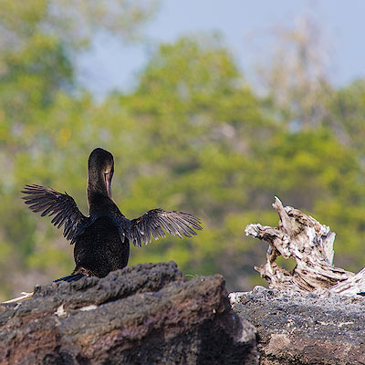
On the volcanic rocks by the shore, we see another bird endemic to the Galápagos Islands, the Flightless Cormorant. The Flightless Cormorant lives on the west coast of Fernandina and Isabela islands, feeding on small fish and octopus and rarely leaving the shore. Because they have adapted to feeding on fish in the sea, their wings are slowly degenerating and the keel that support the flapping of their wings are getting smaller and smaller. They are no longer able to fly, but they have become good divers.
Flightless Cormorant, Punta Moreno, Isabela Island
Punta Moreno is a large area of volcanic lava field dotted by lagoons. Most of the vegetation is concentrated in the mangroves along the sea and areas around the lagoons.
Mangroves and lava field, Punta Moreno, Isabela Island
Lagoon, Punta Moreno, Isabela Island
The volcanic rocks of the Galápagos Islands are rich in basalt. Instead of explosions of gas and ash high into the sky, eruptions tend to discharge molten lava flowing slowly, much like the volcanoes of Hawaii. There are two main forms of lava flow. The faster flowing lava is called ‘a’a (hurt), which forms a jagged rocks as it cools; the other type of lava flow, pahoehoe (ropy), moves much more slowly and cools to a relatively smooth surface with a twisted texture, hence the name “ropy”. Lava field in Punta Moreno are mostly of ‘a’a type. There are sharply edged volcanic rocks everywhere, so you have to be extra careful when walking.
Lava field, Punta Moreno, Isabela Island
Punta Moreno, Isabela Island
Punta Moreno, Isabela Island
The barren lava fields have no water to support anything, but there are always plants that have managed to take root among the volcanic rocks. All three species of cactus unique to Galápagos can be found in Punta Moreno. Little by little they change the composition of the soil, and over time, when water is available, large areas of vegetations will grow here.
Thin Leafed Darwin\'s Shrub, Punta Moreno, Isabela Island
Candelabra Cactus, Punta Moreno, Isabela Island
Prickly Pear Cactus, Punta Moreno, Isabela Island
Lava Cactus, Punta Moreno, Isabela Island
As we walked among the dry lava, Marco explained the landscape, flora and fauna of the surrounding area. The occasional lagoons not only support water plants and shrubs, but also provide a place for birds to enjoy. We found two pairs of flamingos in one of the larger lagoons. The flamingos in Galápagos are small and not very numerous. From March to July is the breeding season and it is easier to spot them at such lagoons.
Galápagos means “Island of the Tortoise” in Spanish, and its English name is the Colón Islands. Each island in the archipelago has both English and Spanish names. In the English-speaking world, we call the islands by their English names, but the name Galápagos is just more popular.
Our flight was scheduled to leave at 6:45 a.m., so we woke up at 4 a.m. to leave the hotel and arrived at the airport around 5 a.m. The travel agent had already collected our tickets. The Galápagos Islands are far away from the South American continent and in order to protect the natural environment and control the number of tourists and residents, each visitor to Galápagos has to buy a $20 TCT card and have their luggage checked separately. Probably because it was still early in the morning, there were not too many people in line.
It was raining sporadically during the boarding time, but the plane was on time. Two days ago, it was already midnight and we couldn’t see anything. This time, we were able to see the majestic Andes mountains, the city, the quarry and mining factory surrounded by mountains.
Andes near Quito
The flight from Quito to Galápagos is via Guayaquil. Guayaquil is the largest city and important port of Ecuador. The Guayas River flows into the Pacific Ocean, forming a vast delta, and the land is fragmented by the river. The plane follows the Guayas River when we are about to land. We can see the river side gradually changes from swamps and farmlands to a densely populated city.
Guayaquil
The plane stopped in Guayaquil for about an hour before preparing to take off again. The flight attendant announced that the cabin doors would be closed and that the aircraft would be sprayed with insecticide. This procedure is required by the World Health Organization for all aircraft flying to Galápagos. The spray came out of the air vents and lasted for about a few seconds. We hardly noticed anything, except for the faint sound and a slight smell.
After about two hours of flight, the plane entered the skies over the Galapagos Islands. The airport we arrived at was on Baltra Island, separated from Santa Cruz Island by a narrow channel about 400 meters wide. The sea was foggy as we were about to land, and we could slowly see scattered small islands on the sea surface. Baltra Island is very small, bare and almost devoid of vegetation. It is mainly used as an airport.
Approaching Galápagos
After getting off the plane and buying the $100 per person ticket to the national park, our journey in Galápagos officially began. Tourists on the same yacht gathered in front of their buses. Our guide, Marco, arrived as well, a sturdy man who spoke excellent English. Marco was a great guide and the key to our perfect trip.
The embarkation dock for the cruise was Puerto Ayora on the south shore of Santa Cruz Island, Baltra Island is on the north shore and we had to cross the whole island. After disembarking the ferry, we started heading towards the high land of Santa Cruz Island. Looking at the map, this section of the road is a straight line. As we gained altitude, the surroundings changed from bare volcanic rock and low Mangroves to a dense “forest” of vegetation. The landscape of the galápagos Islands follows a similar pattern: the low elevation by the seaside is characterized by sandy beaches and arid, barren land with only low vegetation such as cacti and mosses; inland, the presence of mountains makes it easy for rain to fall, which can support lush vegetation.
Itabaca Channel between Baltra and Santa Cruz Island
A few steps from the parking lot, a huge deep crater appears in front of us. The pit crater is approximately oval in shape, with a diameter of about 150 meters on the long side. The walls of the pit are straight up and down, almost perpendicular to the ground, and from the four walls to the bottom of the pit are covered with vegetation. It is inaccurate to call it a crater, because it is not created by a volcanic eruption.
The volcanic activity did not stop after the volcano erupted to form the island exposed to the sea. The lava flows along the gaps in the rocks. The lava on the outside is slowed down by the rocks and gradually cools and solidifies; while the lava on the inside flows faster, and the gaps gradually expand over time. When the lava runs out, a hollow tunnel is formed. Such tunnels are quite common in the highlands of Santa Cruz Island. After thousands of years of corrosion, some of these underground tunnels have collapsed and formed the deep crater in front of us.
Twin Craters, Santa Cruz Island
Los gemelos has two deep craters, on either side of the road. Marco led us along the trail, explaining the flora and fauna around us along the way. The most amazing thing was the plants around us that were nearly 10 meters tall. Technically speaking they are not trees, but a type of dandelion. Their seeds were carried here by the wind and took root among the dry volcanic rocks. As the terrain of the volcanic island rose and precipitation increased, the plants were able to survive. With no competition, the otherwise common low-growing daisy plants can grow more than ten meters tall, covering most of the uplands of the high elevation islands, including Santa Cruz Island, and forming dense forests.
Scalesia tree, Around Twin Craters, Santa Cruz Island
Short-eared owl, Santa Cruz Island
Leaving Los gemelos, our next stop was the highlight of our trip on Santa Cruz Island, a visit to a tortoise ranch, Rancho El Manzanillo, and once we got off the main road, we could already see the turtles walking slowly along the dirt road. It’s called a tortoise ranch, but it is not fenced, the tortoises can wander in and out unhindered. This farm is the partner of the Charles Darwin Foundation.
Giant Tortoises, Rancho El Manzanillo, Santa Cruz Island
Rancho El Manzanillo, Santa Cruz Island
Upon entering the farm was a large open shed that could accommodate 30 to 40 people eating at the same time. Two of us, a family of four from California and an old British couple were the only tourists on the boat. Since there was still room left, a young British couple and a female backpacker from Korea joined us. There were eleven people in total. There are a lot of tourists on Santa Cruz Island. This happens all the time.
Rancho El Manzanillo, Santa Cruz Island
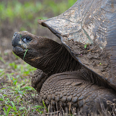
A map of the distribution of Giant Tortoise on each island, as well as illustrations of the different forms of different species, is posted on the wall on one side of the hall. The Giant Tortoise is not only the source of the name of the Galapagos Islands, but also one of the most important species that supports the theory of natural evolution. More about it will be covered later.
After lunch, we put on our rubber boots and went out to the open muddy areas to have a close look of the tortoises. Marco had already told us to keep at least two meters away from the wildlife. The tortoises are huge and this distance was enough to get a good look at them. Besides, the turtles were not afraid of people and often walked slowly past us, seemingly unconcerned with our presence.
Giant Tortoises, Rancho El Manzanillo, Santa Cruz Island
There is a small pond in the middle of the open area, probably from the rainwater gathering. We were in the center of Santa Cruz Island, about 400 meters above sea level. July is the dry season on Santa Cruz Island, but the highland is often engulfed in fog and the air is moist, which allows the vegetation to grow. This drives tortoises to migrate to higher ground. They like to rest in muddy ponds, sometimes with a dozen Giant Tortoises gathered together, and it is said that being covered in mud protects them from mosquito bites. When the rainy season comes, the Giant Tortoises migrate to lower elevations on the island where the food is more nutritious.
Giant Tortoises, Rancho El Manzanillo, Santa Cruz Island
Tortoise migration routes on Santa Cruz Island
We stayed here for about an hour and could see dozens of Giant Tortoises moving around, including a few huge males. The males were over a meter long and could weigh up to 300 kg; the females were much smaller. June and July is the mating season for Giant Tortoises, and we also witnessed a male chasing a female. It seems that the Giant Tortoises can run pretty fast when they are in a hurry, they can advance about 10 meters a minute.
After leaving Rancho El Manzanillo and driving for another half hour, a small town appeared in front of us. We got off the bus at the harbor, Marco briefly introduce the surrounding area and gave us an hour and a half of free time, then we met at the harbor at 4:30 to board the ship.
Puerto Ayora, Santa Cruz Island
I had thought that Galápagos was just a large national park, but in fact the national park covers about 97% of the area, with the remaining 3% inhabited by humans. The largest town is Puerto Ayora, where we are located, with 12,000 residents. Because Santa Cruz Island is located in the center of the entire archipelago, it is the departure point for most tourists and has the most developed commercial and service sector. The second largest town is Puerto Baquerizo Moreno on San Cristobal Island, that is the capital of the Galapagos Islands, with a population of about 7,000 people.
Puerto Ayora, Santa Cruz Island
Charles Darwin Street runs along the harbor, lined with restaurants, bars and souvenir stores, and small and large hotels are tucked away in the streets of the city. There are two main ways to visit the Galapagos Islands, one is land-based, where visitors stay in hotels on several of the larger islands at night and visit the sites on the island during the day or take a speedboat to other islands. There are many one-day excursions from Santa Cruz Island to the main islands. The advantage of this way is that it is cheaper and with more choices. In comparison, the cruise option is much more expensive, but it is much more enjoyable as you don’t have to spend hours rushing from island to island and you can visit more distant islands and stop at more attractions.
Puerto Ayora, Santa Cruz Island
We walked all the way down Charles Darwin Street to the small fishing port. Fishermen return from their daily fishing trips and land here, where fresh fish are cleaned on the spot and sent to the restaurants. There are always a few seals and pelicans waiting for the fishermen to throw them something. Sometimes fights break up for the fish or seals can sneak away fish on the ground. This is probably one of the most unique sight in town.
Pelicans at the fish market, Puerto Ayora, Santa Cruz Island
Fish Market, Puerto Ayora, Santa Cruz Island
We sat down at a restaurant, had a beer and rested for a while before returning to the port. Puerto Ayora was commercialized, but you can always found a few Marine Iguana on the roadside if we looked down; pelicans and grey herons stood on the mangroves by the sea; baby seals would jump on the dock and interact with the visitors; and a group of rays often swim elegantly in the water under the dock. All these remind us that the unique and mysterious natural world is not far away, waiting for us to explore.
Marine Iguana, Puerto Ayora, Santa Cruz Island
Golden Ray, Puerto Ayora, Santa Cruz Island
Pelican on mangroves, Puerto Ayora, Santa Cruz Island
But human settlement has also had a real impact on the environment. There have been cases of human pets attacking wildlife. One study found that the human food makes it easier for birds to acquire food. After decades of evolution, the pinches living in Puerto Ayora have significantly smaller bills than their counterparts in the forest.
At 4:45, we boarded the Seaman Journey by the zodiac. For the next seven days, we will sail around the western islands of Galápagos.
19世纪末,为了纪念厄瓜多尔独立100周年,原本位于广场中心的喷泉被移到广场的一侧,在喷泉所在的位置树立起纪念独立的纪念碑,广场的名称也从殖民时期的“大广场(Plaza Grande)”改名为“独立广场(Plaza de la Independencia)”。一般认为,于1809年8月10日成立的自治政府和发表的宣言标志了厄瓜多尔独立的最初诉求,又被称为“the first cry of independence”(独立的第一声呐喊)。实际上在此之后,厄瓜多尔的独立又经过了多次的反复,所以说起厄瓜多尔真正从西班牙殖民统治下独立的时间,还真没有一个统一的说法。
圣殿教堂(Iglesia de El Sagrario)就在独立广场到García Moreno的转角处,实际上可以算是基多大教堂的一部分。走入教堂,最让人惊叹的要数金光耀眼的祭坛。教堂继承了西班牙教堂装饰精细繁复的特点,木制祭坛的每一处浮雕花纹,柱身、柱头上的装饰,覆盖了祭坛的每一寸表面,无不精细绝伦。教堂的灯光虽然昏暗,镀金的祭坛却依然灿烂得让人难以侧目。金子对人类果然有一种天然的魔力,让人忽略其它的东西,实际上教堂翡翠色的穹顶也是非常漂亮。
Iglesia de El Sagrario
Iglesia de El Sagrario
再向前走是耶稣会教堂(Church of la Compañía de Jesús),它的街口也有一座十字架。耶稣会教堂始建于1605年,花了160年才建成。教堂的面积不是很大,却是基多最著名的教堂之一。在教堂建造的过程中混合了多种建筑风格,其中以巴洛克风格为主体,这从教堂的正立面就可以看的出来。教堂的大门两侧是螺旋式的所罗门柱(solomonic column),柱顶是极具装饰性的科林斯样式(Corinthian order);上层的柱式有所不同,但花纹同样精美。复杂、精细甚至有些夸张的装饰正是巴洛克建筑的特点。教堂的内部更是全部以金叶覆盖,极尽奢华之事,可惜我们没能够进去参观。
Church of la Compañía de Jesús
Church of la Compañía de Jesús
Church of la Compañía de Jesús
从García Moreno大街向右一转,就到了圣弗朗西斯科广场(Plaza de San Francisco)。广场的西侧是圣弗朗西斯科教堂,这是基多最早的天主教堂。靠近教堂的一角是一家历史悠久的酒店,Casa Gangotena,在殖民时期以前曾经是印加的行宫。
面包山是基多一日游的最后一站。导游的车沿着山路徐徐而上,不一会就到了山顶。面包山上最醒目的是山顶上圣母玛丽亚的雕塑(Virgin of El Panecillo)。雕像建于1976年,有45米高,由7400铝片拼接而成。圣母的形象是手持锁链,拴住脚下踩着一条蛇。这是西方宗教和艺术中常见的圣母玛丽亚的形象,蛇代表邪恶,圣经中表现的意义是圣母借助耶稣的力量可以战胜原罪和魔鬼。比较与众不同的是圣母像身后的翅膀,因为翅膀往往只有在天使的形象中才会出现。雕像的作者西班牙人Agustín de la Herrán Matorras应该是有意致敬著名的“基多的圣母(Virgen de Quito)”雕像。这座高120厘米的木像作于1734年,又被称为“舞者”,形象更加的灵动、栩栩如生。
2018.6.28As usual, our trip to Galápagos was not fully confirmed until only days before departure. Up until two weeks before departure, I was torn between Galápagos and Greenland. I even had the connection flights between Greenland and the Faroe Islands all planed out, but in the end it felt like time was running out, and it was much easier to plan the Galápagos plan, mostly because we would stay on the small cruise boat without having to think about the daily itinerary. The week before we left, the cruise boat was finally confirmed, the itinerary was good, and the travel agent gave us a free day trip in Quito.
If you read the online travel forums, Quito is described as an super dangerous city. Someone even said that all taxis in Quito have a Panic Button, and if someone opens the door and jumps in, the passenger can push the button and the camera in the taxi kicks in and starts recording. We didn’t see such devices in a taxi anyway. Quito, like many cities in South America, or most of the less developed countries of the world, is chaotic and noisy, but as long as you don’t go to the unsafe neighborhoods at night, it’s usually far less scary than it’s described online.
Flights from the US to South America always seem to arrive at midnight. We had a connecting flight in Miami, the flight was scheduled to arrive at 10pm, but it was actually more than an hour late. Luckily, we had arranged the hotel pick up in advance. Quito’s international airport is quite far from the city and takes about 50 minutes to reach the hotel. Passing through a valley, we saw city lights ahead, we thought we were not far from Quito. The driver told us it was Tumbaco and was only halfway there.
It was one o’clock in the night when we arrived at the hotel and it took almost ten minutes before anyone heard the doorbell and came out to check on the door. Our hotel is Hotel Casa Q. It is located in the business district of Quito, not quite downtown. The hotel is not large, but well maintained. You can notice that the owner put a lot of thoughts into the design. It was at breakfast time the next day that we were able to see what the surrounding streets looked like.
Hotel Casa Q
Quito street near Hotel Casa Q
The booked city tour was supposed to start at 9am and the guide arrived at almost 10am. This is common in South America and part of the local culture. The first stop on the day trip is a cable car ride up Pichincha Volcano. Quito is located in a valley at the eastern foot of the Pichincha volcano. At 10 o’clock, the streets are very crowded with traffic. The main road is mostly two-way, four-lane and looks modern, and but the small streets are still a bit messy.
Quito Street
Quito street
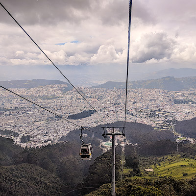
The gondola to Mount Pichincha is called TelefériQo. the station at the foot of the mountain is on the edge of Quito, the facilities were still new and there were not many tourists. Probably the maximum capacity of one car is six people, there are six circles on the ground where the car was boarded, and each one of us stood in the circle waiting for the car.
The TeleferiQo to the top of Cruz Loma
The cable car took about 20 minutes to get from the foot of the mountain, which is 10,226 feet above sea level, and the drop-off point is 12,943 feet. The vegetation at this height is mostly shrubs with some low trees. Further up, the woods fade away and the grass gets shorter and sparser. At the top of the mountain is the Ruku volcano, which is 15,696 feet above sea level. The most recent eruption was in 1999, falling several inches thick of ash into the city of Quito.
Cruz Loma
Rucu Pichincha climbing route
Cruz Loma
We walked up to an elevation of about 4,000 meters. This is the highest elevation we’ve ever been to. Indeed I had to breath heavier when I walked faster. There are plenty of places in between to stop and overlook the city. July is the dry season in Ecuador. According to the guide, it should be sunny all day, but the clouds were low and the city of Quito was hidden from time to time in the clouds. It’s on the cable car when we ware under the clouds, we were able to get a panoramic view of Quito.
The TeleferiQo to the top of Cruz Loma
The following day trip was a city-tour to the old town. I will cover it in another blog.
We took the taxi from the marketplace to the hotel in the afternoon. We had book the dinner at Zazu. It’s only one block away from the old, there were plenty of time left to explore the surrounding places. The hotel attendant said there’s a Food Garden not far from where we were. Just make a turn from the hotel to the street where Zazu is, we found the road lined with restaurants from the low-end street food to the high-end establishments. We walked into o restaurant called Swing at the corner. Listening to the familiar disco dance music, there’s suddenly a feeling of lost in time.
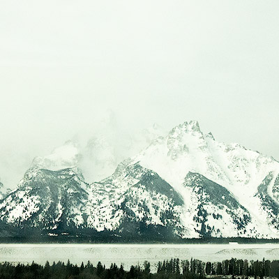
Overlook mountains at La Pradera
Zerdo
La Pradera Food Garden is just two blocks from us at the intersection of de la Republica Avenue. It looks bland from the outside, but it’s getting more interesting when you walk in. The modest area is home to dozens of open space eateries, each with its own distinctive style, with relaxing atmosphere. Such a place to put in America would also be a gathering place for trendy young people. It was 6pm and there weren’t many people. Maybe it’s because it’s not the weekend, or maybe such spending is still a bit high for locals.
La Pradera Food Garden
La Pradera Food Garden
Dinner reservations at Zazu are at 7pm. From the design to the plating, Zazu is one of the more upscale restaurants with moderate prices by American standards. We ordered the chef’s tasting menu. It look certainly beautiful, but the taste were not as exciting.
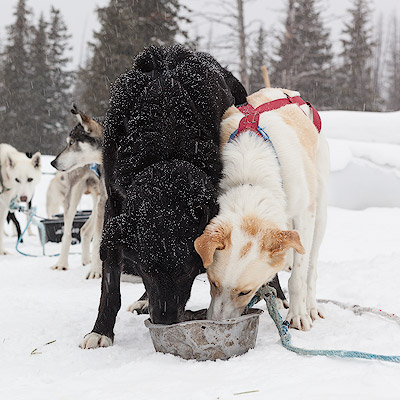
我们订的是半天的活动,近中午时有车来接。先是到Jackson镇的旅馆接上另外三对夫妇,然后一路向北,到Moran再往西,大约开了一个小时多一点儿,才到了位于Togwotee山脉的活动地点。这里是北美大陆的水域分界线,所以这里的狗拉雪橇活动叫做“Continental Divide Dog Sledding”。