Colorado Mountain Towns – Grand Mesa

2021.9.29

I had pondered about where to go after Telluride and finally decided to drive to Grand Junction, took a detour through the Grand Mesa. This will cover most of western Colorado.

We had planed to walk along the mountain rim in the early morning, but the weather was so gloomy that it was going to rain. It was only a little drizzling in the beginning, after a short walk, the rain got heavier. We had to run back to the hotel where I had lunch the day before.

The Peaks Resort & Spa, Mountain Village

The rain didn’t look like it was going to stop, so we had to take the gondola to the small plaza on the other side of the resort and buy some snacks for the trip.

Mountain Village
Mountain Village

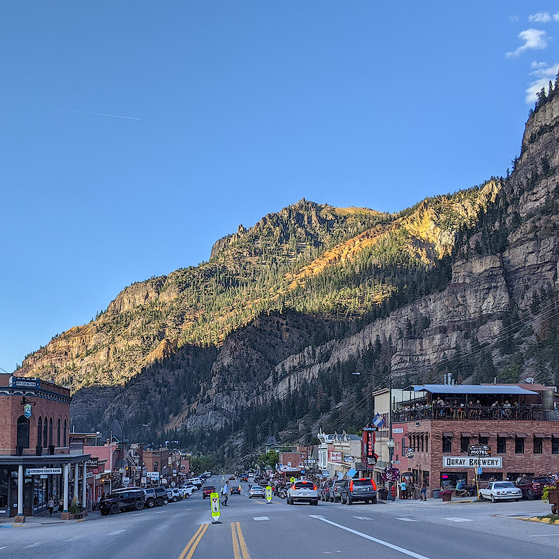
After leaving the San Miguel Valley, it started clearing up and by the time we reached Ridgway, the sun was shining brightly. As the gateway to the San Juan Mountains, several railroads connecting the mining towns of Ouray and Telluride intersect here. Most of these railroads were abandoned in the 1950s and 1960s, and now Ridgway’s most famous landmark is the True Grit restaurant. The 1969 western film was filmed near Ridgway and Ouray, and won John Wayne an Oscar for best actor.

Ridgway
Ridgway
True Grit Cafe, Ridgway

Black Canyon of the Gunnison (Black Canyon of the Gunnison) is a national park 12 miles west of Montrose. We decided to visit the park first and then go back to Montrose city for lunch.

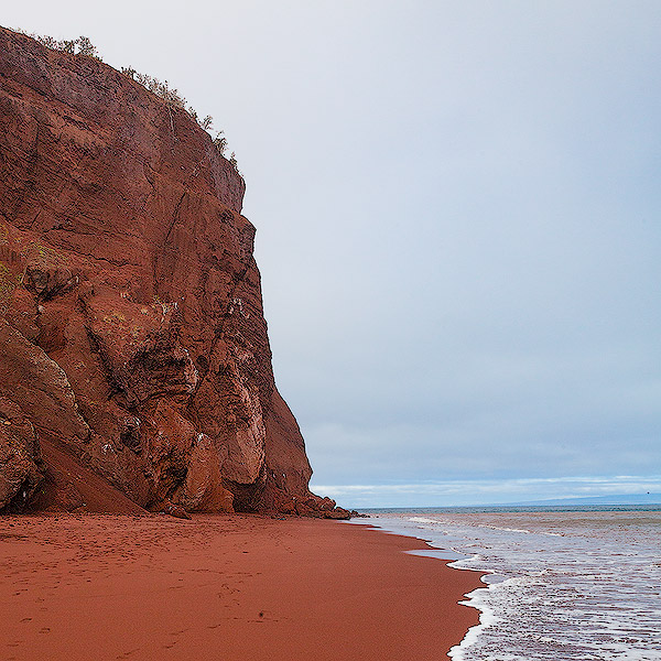
Black Canyon is a canyon formed by the erosion of the Gunnison River. Compared to the Grand Canyon, Black Canyon is far less dramatic and colorful, but the Gunnison River has a much faster drop per mile than the Colorado River in this section of the valley. As a result, the mountains on both sides of the Black Canyon are much steeper, and even during the day time, the rock walls are mostly in the shadows where the sun does not shine, giving them the dark color, so it is the canyon named.

Black Canyon of the Gunnison National Park

From the south entrance of the national park, there is only one road that runs along the south rim of the canyon. At each viewpoint, visitors can get out of the car and walk the trail to the cliff. The elevation here is over 8,000 feets. The cliffs are mostly gray and black but vegetation at the top showed the fall colors. The canyon is quite spectacular, with some places offering a panoramic view of the Gunnison River flowing out of the valley and into the plains, but after seeing more of it, it’s pretty much the same. We drove all the way to High Point at the end of the road, and then back the way we came.

Black Canyon of the Gunnison National Park

We had a quick lunch at a Japanese restaurant in Montrose, you shouldn’t have much hope for Japanese food in a place like this.

As we continued north on Highway 50, we could already see the mountains ahead of us, with their flat tops stretching eastward. From Delta, I turned right and followed the navigation on a winding route that eventually took us to Highway 65 to the Grand Mesa.

About halfway to the Grand Mesa there is a small town called Cedaredge. On the side of the road is the Pioneer Town Museum, which commemorates the pioneers of the westward movement in the U.S. history. We arrived at 5 p.m. and the museum was already closed. We could only look outside at the three tall wooden barns and take a short break.

Pioneer Town, Cedaredge

Soon after we left Cedaredge, the road rose with the mountain and the leaves gradually changed color from green to yellow. The top of the Grand Mesa is a layer of basalt nearly 300 feets thick, forming a vast flat top because it is harder and more resistant to erosions than the surrounding sediments. It is the largest flat-topped mountain in the world.

Grand Mesa
Grand Mesa
Grand Mesa
Grand Mesa

The summit is about 10,000 feets above sea level. Because of the high precipitation, more than 300 lakes of various sizes are formed. Near the top of the mountain there are still rich autumn colors, but at the top broad-leaved forest can no longer grow, only a pine forest exists. By the time we reached the summit it was 6pm. The ground around the lake was muddy, so we couldn’t go any deeper. There was no one around. The gloomy feeling was in stark contrast to the intense autumn colors ten minutes before.

Grand Mesa
Grand Mesa
Grand Mesa
Grand Mesa
Grand Mesa
Grand Mesa

It was a wild downhill ride after that. I remember a few years ago coming out of Aspen towards the other direction of I70, the mountains on both sides were treacherous, and the highway through the Rocky Mountains was an engineering marvel back the time when it was built.

Our hotel was located right next to the downtown street, simple, spacious and clean. When we walked out for dinner, it was already after 8pm. Many restaurants were ready to close. We had dinner at a Mexican restaurant called Las Marias. From the decoration to the food, it has the feel of a Mexican family restaurant. The taste is good and it’s very affordable. The owner is an old lady, I asked her for Maxican spicy sauce, and she confirmed with me that it’s what I wanted. I got two plates of it. It was quite spicy indeed!

Las Marias, Grand Junction

It was almost 10 o’clock when I came out of the restaurant. The streets of downtown Grand Junction are clean and the stores look newly built, so there is no feeling of insecurity. There are many statues on the roadside, very walkable city!

Grand Junction
Grand Junction
0 Comments

Colorado Mountain Towns – Million Dollar Highway

2021.9.28

The plan for today was to drive to Silverton and enjoy the fall colors along the way. There was still time to do something around Telluride in the morning. Several of the famous hiking trails do require hours to finish, so I decided to find a trail to run around the area.

The Galloping Goose Trail starts just outside of Telluride, near the fork of Route 145. It follows the San Miguel River, soon turns into the South Fork San Miguel River. While the scenery is not as impressive compared to what I saw on the mountain yesterday, the origin of Galloping Goose has an interesting story to tell.

During the mining boom of the 19th century, there was a railroad connecting Ridgeway, Telluride and Durango. The remains of the station still stands at the point where the San Miguel River meets. In the 1930s, when the mining industry was declining and many related industries were closing down, the RGS company, which operated the railroad, came up with an idea. They replaced some of the freight train with gasoline-powered railcars and turned the railway that transported ore into a tourist route. The name Galloping Goose came from the fact that the cars kept swaying back and forth as they drove through the mountains, and honking sound of their horns.

Galloping Goose Trail

I took a rest after the run. It was already noon time when we arrived at Dallas Divide. The hillside was colorful but the sun was to bright. It was not a good time for photography. I didn’t expect the weather and scenery to be completely different at the same location a few hours later.

Dallas Divide
Dallas Divide

We stopped at Ouray to have lunch and looked around those old buildings off the main road. While we were stadning in front of the old courthouse, an older lady was taking pictures next to us. With an excitement on her face, she told us that in the movie “True Grit”, this was the door that John Wayne walked out from the courthouse. She must be a big fan of the western movie star. She told us that there is also a bar called True Grit in Ridgway that is worth visiting.

Ouray, Colorado
Ouray, Colorado
Ouray, Colorado
Ouray, Colorado

We wanted to have a quick lunch and head to Silverton, but ended up spending a long time waiting for our meal at a cheap Thai restaurant. By the time we left, it was after 2:00 and clouds were gathering in the sky. It looked like the rain was coming. After leaving Ouray, the road started winding up the mountain. By the time we reached the viewpoint of Bear Creak waterfall, the rain was already pouring down. The mountains in the distance were hidden behind the dark cloud, it’s raining quite heavily.

Million Dollar Highway

The name “Million Dollar Highway” has been given to the stretch of highway 550 between Ouray and Silverton, and some say it is because of the high cost of building the road; others say the dirt used to fill the road contains gold ore and is worth a lot of money. This section of the road is known as one of the most beautiful roads in the United States because of its treacherous terrain and beautiful scenery. Along the “Million Dollar Highway” slowly, one side of the road is high mountains, the other side is no guardrail cliffs. Because of the rain, the road was slippery, and there were stones rolling down the mountain. We probably had the worst weather in the best of seasons, and despite the stunning autumn colors, I didn’t dare to be distracted, especially when driving on the outside, I was really nervous.

There are several continuous S-shaped turns in the highway, and the rows of aspen trees on both sides go up the mountain, you really cannot see how unique it is in the photo. There is a small lake called Crystal Lake about a third of the way out, and the hillside from near to far is completely covered with golden aspen trees. It is very imposing even in the misty rain. If the weather is good, it would be nice to have a walk in the mountains.

Million Dollar Highway

After crossing the Red Mountain Pass of 11000-feet elevation and taking a big switchback, the road opens up and the rain slowly stopped. After an hour driving, we arrived in Silverton. The small town is located in the valley of Animas River, surrounded by several mountains of nearly 14,000 feets. Highway 550 continues southward, and there are two more high passes to reach Durango.

Silverton, Colorado
Silverton, Colorado

Silverton’s history is similar to Ouray and Telluride in that both started with mining and slowly moved into tourism. Silverton is a bit smaller than the other two cities, perhaps because of the heavy mountainous terrain. For outdoor lovers, it is an ideal starting point for backcountry sports.

We walked along the main street of Silverton and tried to find a cafe or something to warm us up. The time was around 3:30 pm and only some souvenir stores were still open, all the restaurants and cafes were closed. After walking back and forth for a while, we found a restaurant on a side street that was still open. The clerk said there was still some coffee left in the kettle. A cup of hot coffee was enough to cheer us up. Old photos of Silverton and posters of western movies of the 50s and 60s hanging on the wall. It’s like walking back to the history standing in the restaurant.

Silverton, Colorado
Silverton, Colorado
Silverton, Colorado
Silverton, Colorado
Silverton, Colorado
Silverton, Colorado

It didn’t rain much on the way back, and since I had already done it once, the drive didn’t feel so terrifying. At the top of Red Mountain Pass, there is a remnant of a trestle used for mining, from which you can see the magnificent fall colors of the surrounding mountains. The mine ceased operations in 1979, and the reclamation project has been underway since then. The mine has been preserved as part of the local history as well.

Million Dollar Highway
Idarado Mining, Million Dollar Highway

It was still cloudy when we were at the Ridgeway, but it gradually cleared up as the road slowly ascended. I wondered if the rain would bring the snow on the mountains. As we were approaching Dallas Divide, I looked into the distance at the San Juan Mountains at the left. There was snow on top! It felt like a dream come true. I stopped the car and took several pictures of the beautiful fall colors with the background of the snowy mountains.

Near Dallas Divide
Near Dallas Divide

Dallas Divide’s parking lot was already crowded with people, tripods lined up along the fence. There is only one photographer standing on top of his car. He had the best location and view point. It was barren dry and hot in the noon and nothing on the mountain tops, a few hours of rain made the mountains covered with snow. The photographer’s passion and admiration to the nature is best reflected in this photo.

Dallas Divide
Dallas Divide
Dallas Divide
Dallas Divide
Dallas Divide
Dallas Divide

By the time we got back to the hotel it was after eight o’clock. We looked around the mountain village and couldn’t find a restaurant in our liking, so we decided to have dinner at the restaurant in the hotel. We ordered flat bread with different toppings. It turned out that the dish was so huge that can feed at least two more people. The taste was still quite good.

Restaurant in Madeline Hotel & Residences
0 Comments

Colorado Mountain Towns – Last Dollar Road

2021.9.27

Today’s plan is to do a hiking in the morning, starting from Mountain Village, taking the Ridge Trail up to San Sophia Station, the highest point of the gondola; then take the Village Trail back down to the resort. The total distance is about 7 miles.

The trail starts at the gondola station, but the beginning of the trail is not very well marked and is mixed up with several downhill trails. It took me a few times to find the way I wanted to go. The Ridge Trail is quite steep, mostly 10 to 15 degrees uphill. The trail starts with some switchbacks, and then it goes up along the mountain ridge.

I started at 8:00 a.m. and the sun was still behind the San Juan Mountains. The trail runs through the aspen forests. I could see Telluride and the mountains across the town only occasionally, most of time, the view was blocked by the forest. The route up the mountain was a little more than 2 miles, and it took me about an hour to reach the top. The sunlight started reaching the tip of the mountain and lighting up the slope, and the color of the aspen leaves were getting brighter.

Ridge trail to village trail, Mountain Village

At the top of the mountain is the transfer station of the gondola, San Sophia Station, from where many people take the gondola to the top and either descend or go further to other hiking trails. Finally there is an open view, with the Mountain Village on the slopes below, and the distant mountain range with Sunshine Mountain and Wilson Peak to the west.

San Sophia Station, Telluride
Ridge trail to village trail, Mountain Village

The Village Trail descends slowly, except for some sections of gravel or loose dirt, and is very easy to follow. There is a straight and gentle slope somewhere in the middle, and you can see the mountain range across the Telluride and San Miguel River valleys, several of which are 14ers. The aspen extends to halfway up the mountain. This is the most epic scenery on the trail, even if you are in a hurry, you have to take a break here and take a deep breath, all the hardships of the trek are rewarded at this moment.

Ridge trail to village trail, Mountain Village

Back to the hotel and we went for lunch. We chose a restaurant called Altezza. It is in the hotel of The Peak Resort, which is located on the outskirts of the Mountain Village. The restaurant had a good rating and when we arrived we found that the view was even better. Sitting on the patio, we could see the golf course by the hotel, the mountains in the distance, the colorful autumn colors from golden to orange to crimson, and the meal was quite delicious.

Altezza at the Peaks, Mountain Village

Last Dollar Road is a mountain road that starts from Telluride, crosses the San Juan Mountains, and reaches Dallas Divide. Known for its beautiful scenery and winding roads, this road cannot be considered tough for expert off-roaders, but it is impossible to drive the entire length without the right vehicle. Around Telluride, this road is highly recommended as a top choice for enjoying the fall colors. We planed to drive and see how far we could go.

The road starts at the roundabout of Route 145 outside of Telluride, from where it turns up the hill. Before reaching the airport, T60 forks to the right and becomes a dirt road. As the terrain rises, the views open up. Not too far into the trail, I stopped at the Deep Creek trailhead and took this photo. I was very happy with this photo, from the change in color to the layering of the aspen forest.

Last Dollar Road, Telluride

The road continued up the mountainside. Clouds gathered in the sky and suddenly it started to rain. it always seems to rain in the afternoon in the San Juan Mountains, and the stormy sky is a perfect match for the autumn colors. What impressed me the most was the color and texture of the cascading trees on the rising hillside, but there weren’t many places to stop on the roadside, so I couldn’t find the right spot to capture the ideal shots.

Last Dollar Road, Telluride

After reaching a open flat area, Last Dollar Road made a 90-degree turn to the right and the road became even steeper. I gave up my intention to continue up the road. The mountains lined up in the distance, separated by river valleys. The sun shone through the tumbling clouds on the rows of golden aspens. A few vehicles campped here, it is perfect place to enjoy the magnificent scenery.

Last Dollar Road, Telluride

There is a trail off Last Dollar Road that leads through the aspen trees. Carrying my tripod, I walked deeper into the woods along the path and was surrounded by silence. The aspens are strong and lush, with bright yellow leaves and snowy white trunks, making this a great trail for meditating alone or walking with a loved one.

Last Dollar Road, Telluride

On the way back, instead of returning directly to the resort, we continued driving south along Route 145. This way forward greeted the majestic mountains and the bright fall colors were a sight to behold. We stopped at a small lake called Cushman Lake on the side of the road. It was drizzling a bit, but it didn’t affect the mirror-like reflection of the aspens and mountains.

Cushman Lake, Telluride

Back at the hotel, we took the gondola to Telluride again for dinner. We had booked the place the day before and the address is the name of the restaurant, 221 South Oak. This is one of the best restaurants in Tulluride, we ordered Lamb chops and Bison short rib, which were quite good.

221 South Oak, Telluride
0 Comments

Colorado Mountain Towns – Telluride

2021.9.26

I got up early and planned to go for a run around town first. Although I started running before the COVID-19, I did run longer and longer during the pandemic. I had always been doing the morning walk around town and taking pictures before. Now everywhere we went, I planned in advance where I could run.

Telluride is 8750 feet above sea level, but I didn’t feel much uncomfortable during the run. The sun was still just peeking out from behind the mountains, illuminating the tip on the opposite side of the mountains. The aspens on the hillside had turned yellow and were being lit up by the morning sunlight.

Telluride
Telluride

I ran along the main road of the town. Telluride town is small, I already reached the other side of town a little more than half a mile. The road is lined with stores, galleries and restaurants, and looks much more lively and fashionable than Ouray. Similar to Ouray, Telluride prospered in the second half of the nineteenth century due to the rise of the mining industry and declined as the price of silver fell. It was not until the 1970s that the first ski resort was built and Telluride became an outdoor sports paradise. A variety of cultural and artistic activities follow, and the town regained its former prosperity.

I first turned left and ran to the Telluride Historical Museum, which was the hospital during the mining boom, on the north side of the town, and then ran through town to the San Miguel River.

Telluride
Telluride
Telluride
Telluride

The San Miguel River originates in the San Juan Mountains that surround Telluride and flows through the town and out of the valley. Telluride is an outdoor sports paradise. In the summer time, the hiking trails crisscrossing the area, and in the winter, ski routes from the top of the mountain run directly into the city.

Beaver Pona, Telluride
Telluride
Telluride
Telluride
Telluride

I ran back to the hotel along the San Miguel River, met up with my wife and headed back to town. We had breakfast at a restaurant called The Butcher & The Baker. The restaurant was recommended by the hotel and was really popular, the waiting line run out the door. Their food were really good and lived up to the reputation.

Telluride
Telluride
The Butcher & The Baker, Telluride
Telluride
Telluride

We only planed to stay in the town for one night and then move to the mountain village. One of Telluride’s most famous sights is Bridal Veil Falls. When the snow melts in the spring, the fall, with a vertical drop of over 365 feet, is massive and can be seen from a distance. In the fall, the water volume is much smaller, but we still planed to go there to take a look.

Heading east along the main road that runs through Telluride, about one and half miles out of town, there is a mill. From here, there is a newly constructed trail that leads to the foot of the falls. With an SUV with sufficient horsepower and a high clearance, it is possible to continue on from here, after several switchbacks, to the top of the falls. There is a deserted power station sites there. I stood at the parking lot by the mill and looked at the trail, feeling little confidence in my rental car, so I took a few photos and turned back.

Bridal Veil Trail, Telluride

The resort is located on a slope on the south side of Telluride, more than 700 feet above the town. The location of the resort cannot be better, standing on the mountain ridge, one can overlook the magnificent San Juan Mountains and Telluride. The Mountain Village and Telluride are connected by the trails and the gondola, these separated yet interconnected areas offer the possibility of a wide variety of activities around Telluride.

The hotel we booked was the Madeline Hotel, located in the center of the resort. As soon as we arrived at the front desk, the staff handed us drinks and beers. The service was quite good.

In the summer timer, Telluride hosts a variety of cultural events and festivals. Sometimes in the town, sometimes on the mountain. When we arrived, there was a classic car and wine festival, as well as an art show. I thought about whether to buy tickets before we left to Telluride. In fact, the art show was held in the central plaza of the resort, right outside the hotel. You probably had to buy a ticket to see the classic cars.

Mountain Village
Mountain Village

We had our lunch at the hotel’s restaurant, Black Iron Kitchen & Bar. Put the taste aside, the dishes looked so beautiful. The ingredients were just a variety of carrots and fruits, with cheese and some purple flower petals sprinkled on top, very colorful and appealing.

Black Iron Kitchen & Bar, Madeline Hotel & Residences, Mountain Village

The plan for the afternoon was to take the Jud Wiebe Memorial Trail near Telluride. It is on the other side of town. Instead of driving, we backpacked and took the gondola to the town. The gondola that connects the town to the Mountain Village is one of the highlights of Telluride. From the resort, we took the gondola 960 feet up to Station St. Sophia at the top of the mountain, then the gondola continues 1750 feet down to the town at Oak Street. The gondola runs from 6:30 in the morning till midnight. The trip takes only fifteen minutes each way, making it very convenient for guests visiting both places. It is a perfect place to enjoy sunrise and sunset, and the entire trip is free to all visitors, such a visionary decision that locals made!

The Gondola, Telluride

The Jud Wiebe Memorial Trail is a three-mile trail with 1200 feet elevation gain. The trail starts gently up and it doesn’t take long to see the whole town of Telluride. The trail is popular because it is not too long and the views are great. In fact, some sections were quite steep, and we felt a little tired after a short while. After all, we were on the mountain at an altitude of nearly 9000 feet.

Jud Wiebe Memorial Trail, Telluride

We returned to town and checked out a few popular restaurants, only to find that they all need reservations. We eventually chose a small restaurant. Actually, the food tasted pretty good.

LittleHouse, Telluride
0 Comments

Galápagos – Playa Las Bachas

2018.07.06

Early in the morning, our boat was moored in the calm waters off Santa Cruz Island. The beach facing us was Bachas Beach, and in the distance we could see the mountains in the center of the island, where we visited the tortoise ranch on our first day.

Bachas Beach, Santa Cruz Island

During World War II, the United States had an air base on Baltra Island, and the remains of the barges used in those days can still be seen on the Bachas Beach. The locals found the word barge was too difficult to pronounce, so they came up with the name Bachas Beach.

Bachas Beach, Santa Cruz Island

Just behind the beach there is a small lagoon where flamingos and ducks often land. There were two greater flamingos standing in the water while we were there. The morning sunlight rendered the mirror-like lake with warm tone, complemented by the elegancy of the flamingos. None of us spoke, blending in with the silence.

Greater Flamingo, Bachas Beach, Santa Cruz Island

Back on the beach, we saw a pelican standing on a reef not far from the shore grooming its feathers, with a few red crabs at its feet. In the distance was a small island that had sunk into the sea, leaving only the crater above the surface. This is the last image of the Galapagos Islands left for us.

Pelican, Bachas Beach, Santa Cruz Island

The boat took us back to the Baltra Island ferry where we took the shuttle bus to the airport. Sitting on a bench at the airport, I actually felt a little dizzy. It is said that people who spend a lot of time on the water get “land sick” on land, and it seems to be true.

Baltra Ferry Terminal

It was about 3pm when we got back to the Quito airport. Having been to Quito airport twice before, once at midnight and once in the early morning before dawn, I had never seen what it looked like until now. It still looked quite modern.

Wyndham Quito Airport

Our return flight didn’t leave until 11pm. We booked a room at the Wyndham Hotel next to the airport so we could get some rest before our departure. The hotel served a dinner buffet starting at 6pm. After dinner we slept in our room for a few hours before boarding our return flight.

Wyndham Quito Airport

The trip to the Galápagos Islands not only allowed us to enjoy the unique natural ecology of the islands in comfortable conditions, but also allowed us to understand Darwin’s theory of evolution in a more direct way. Darwin was inspired by his study of the flora and fauna of the Galápagos Islands, which led to the formation of the theory of evolution. The Galápagos Islands is not the only place in the world that is so amazing and intriguing. Far across the Pacific Ocean, the island of New Guinea is another island with a unique natural and human history. The world is a fascinating place to explore!

0 Comments

Galápagos – Pinnacle Rock

2018.7.5

Our boat left early and made its way north along the coast, arriving at the site of today’s activity, Bahía Sullivan, at about seven o’clock. The bay is located between Santiago Island and Isla Bartolomé, with a distance of only 600 meters between the two islands. With the boat anchored in the bay, the iconic pointy Pinnacle Rock of Isla Bartolomé can already be seen. It’s just that you can’t quite see its uniqueness from this angle.

Frigate, Bahía Sullivan, Santiago Island
Bahía Sullivan, Santiago Island

After breakfast, we ascended Santiago Island from Bahía Sullivan. This is a large area of lava field, extending all the way to the sea, without any beach. The lava are generally in two forms, ‘a’a and pahoehoe. The lava at Bahía Sullivan are mostly in the form of pahoehoe, flat and without any jagged edges. In some places the lava looks like a bundle of rope. You can imagine the look of the hot lava slowly flowing, advancing, cooling.

Bahía Sullivan, Santiago Island

Of course the lava field is not all flat piece, but shows a variety of forms. In some places, a large crack was opened in the middle of the flat volcanic rock, either in a straight line or in a zigzag pattern. The sides of the cracked rocks show brownish-red layer, likely to be iron-bearing. In some places, a bulge rises with an exit in the middle, resembling the shape of a small volcano, and reminiscent of the eggs of the face hugger in Alien. They are the product of small streams of bubbles gushing out of the magma.

Standing in the middle of the lava field, as if in an alien planet. The age of this volcanic rock is very short, only less than two hundred years, the ground does not even sustain plants like cactus, only an occasional clump of weeds can barely survive among lavas.

Bahía Sullivan, Santiago Island

Out of the volcanic area was a hilly area with brownish-yellow soil, presumably ejected from the ground at an earlier time. Walking between the hills, immediately we felt the heat under the scorching sun. In fact, it’s not very far from the shore. In some places, you can still see the magma had also flowed into this area, cooling and freezing in the valley between the hills. Some shrubs can find room to live in such barren land.

Bahía Sullivan, Santiago Island

Lunch was served on the boat at noon, and the crew used the limited ingredients to make shapes of ducks and geese. Probably too cute, no one wanted to touch them, and they were served back after the meal.

Lunch on Seaman Journey, Santiago Island

The afternoon activity was the ascent of Isla Bartolomé. The zodiac took us around the Pinnacle Rock at the edge of the island. The rock were formed by an underwater volcanic eruption and then collapsed to form the unique shape of the pointy top today. Behind the rock is a cave that is home to Galapagos penguins. As we docked, we saw several penguins swimming in the bay.

Isla Bartolomé, Santiago Island

We picked our way up the wooden walkway and soon reached the top of the 114 meter high hill. At the top of the mountain is a small red lighthouse, with a flat open space a few steps below. From here, you can look forward and see the most iconic landscape of the Galápagos Islands. Isla Bartolomé is shaped like a pear, with its long stalk deep into Bahía Sullivan. The pinnacle rock is located on one side and are only then revealed in their full glory. On either side of the shank is a half-moon shaped beach, and in the distance is the black lava field of Santiago Island, where we landed in the morning.

Isla Bartolomé, Santiago Island

Walking down from the top of the hil, I noticed the white plants on the hillside, up the slope and spread over most of the mountain. It’s said the plant is called “Tequila Plant” and the white color comes from the gray hairs on the surface of the leaves, which prevents moisture from evaporating. I don’t actually know what kind of plant this is because the plant used to make Tequila, also known as Agaves, is a giant succulent plant, which doesn’t look like one at all.

Isla Bartolomé, Santiago Island

On the other side of the trail, you can see a variety of volcanic formations, both Spatter corn and Tuff core. Most of them are small, one next to the other, as if one was ejected and squeezed out by the other, which shows the active volcanic movement here. The Galapagos Islands are a treasure that evolved under such a dynamic geological and geographical environment.

Isla Bartolomé, Santiago Island

We set sail in the late afternoon, heading for Santa Cruz Island where we had departed a few days earlier. The sea was calm and the sunset was beautiful. This would be the last stop of our trip.

0 Comments

Galápagos – Chinese Hat

2018.7.4

Itinerary of Rábida Island and Sombrero Chino

Leaving Rábida island, the boat headed northeast along the coast of Santiago Island. In an hour or so, we arrived at Sombrero Chino, which means Chinese Hat in English. Such straw hats are also very common in Vietnam and Southeast Asia, with either round or pointed tops.

The volcanic cone of Sombrero Chino is called “spatter cone“, which is actually the built-up of lava threw out by the volcano vent, so it is usually not too high. Originally part of Santiago Island, over time, weathering made the cone lower and lower, and the sea water gradually eroded the land connecting Santiago Island, creating a channel of about 600 feets.

Sombrero Chino, Santiago Island

We landed at the beach on the north side of the island. Wet landing is generally on the beach, where you disembark the boat in the water and walk to shore, while dry landing requires a suitable reef or dock so you can disembark directly onto land. Sombrero Chino is less than a quarter a square mile in size. We walked south along the coast facing the Santiago Island, with volcanic beaches all along the way. Low plants cover the ground in a variety of colors, from green to dark red, some even extremely bright red. The channel between the two islands is very narrow and the water is turquoise blue.

Sombrero Chino, Santiago Island

Various forms of volcanic rock can be seen on the island, both jagged ‘a’a and gentler pahoehoe. Some are apparently pipes formed by the flow of cooling lava, and collapsed down later. It is similar to the craters on Santa Cruz Island, only on a much smaller scale.

Sombrero Chino, Santiago Island

There is a sea lion colony on Sombrero Chino. We saw many sea lions sunbathing on the beach, with the Sombrero Chino as the background. The trail that you can walk on the island is only about 400 yards. At the end of the trail, we saw a few more familiar marine iguanas, crawling on the volcanic rocks and keeping themselves warm.

Sea Lion, Sombrero Chino, Santiago Island
Marine Iguana, Sombrero Chino, Santiago Island

Just as we were boarding our zodiac and preparing to return to the boat, we spotted two Galápagos penguins on the reef. We had seen them on our second day in the archipelago and had not seen them again until then. They are indeed small, nowhere near as imposing as the Emperor and King penguins. But they are very lucky not to have to go through the long, harsh winters that others do.

Galapagos Penguins, Sombrero Chino, Santiago Island
Islet near Sombrero Chino, Santiago Island

The sea was calm, our boat was moored near Sombrero Chino for the night. As night fell, Marco took us to the top deck. There was no other light source around, so we could see the stars clearly. Marco used a small laser pointer in his hand to shoot a ray of light to point out the location of the constellations.

In the distant sky, we could faintly see a bright red light, in the direction of Isabela Island in the distance. Marco was particularly excited to see it, after confirming that it was indeed the Sierra Negra volcano on Isabela Island. We had walked at the foot of the volcano a few days before. This is the first time I saw the eruption of the volcano with my own eyes, but unfortunately it was too far away. I wanted to take a picture with my camera, but the boat was undulating so much, but you can get the sense of it in this picture.

Night sky and volcano eruptino in Isabela Island, Sombrero Chino, Santiago Island
0 Comments

Galápagos – Red Beach

2018.7.4

Rábida island is located less 3 miles to the south of Santiago island. The island is small in size and rich in volcanic activity patterns. Almost the entire perimeter of the island are volcanic cliffs, and only the beach on the north is suitable for visitors to land.

The lava from several volcanoes on Rábida island is rich in iron, which gives the island its distinctive reddish-brown hue. Near the landing site, the red cliffs are home to nesting Blue-footed boobies.

Rábida Island
Rábida Island
Common Noddy with Prickly Pear Cactus, Rábida Island

The most unique feature of Rábida island is its fine red sand beach. The white waves lap up against the red sand, a beauty that would be ranked on the top among all the beaches of the world.

Rábida Island
Rábida Island

The sky was clearing somewhat as we climbed the hill to the right of the beach. From here you can clearly see the lagoon behind the beach. The hill is also full of Palo Santo trees.

Rábida Island
Rábida Island

As we walked along the path up the hill, it started raining for a while. The red volcanic rocks along the coast were covered with patches of Prickly Pear Cactus, which Marco said they looked like the ears of Mickey Mouse.

Rábida Island
Rábida Island
Rábida Island
Rábida Island

The walkable trails on Rábida Island are not very long. We turned back to the beach in 30 minutes. The beach continues around the hillside. There are sea lions and marine iguanas lying on the beach. Pelicans are nesting on the shore and this is a great place to see them up close.

Pelican, Rábida Island
Galapagos Sea Lion, Rábida Island
Rábida Island
Rábida Island

The distinctive red sand beach always adds a charm to the landscape. At the end of the beach is a towering cliff, as if the world ends here.

Rábida Island
Rábida Island
Rábida Island
Rábida Island

The last thing I have to say is the crew who cleaned our room. Every time we came back from landing, not only were the beds neatly cleaned, but the crew also folded towels into various animal shapes, which shows the crew’s dedication and enthusiasm for their work.

img_20180704_113431
img_20180704_113431

We left Rábida Island before lunch. Our next stop is Sombrero Chino.

Rábida Island
Rábida Island
0 Comments

Colorado Mountain Towns – Ouray

2021.9.25

The Telluride trip was planned at the same time when we went to Jackson Hole in 2018. Because of the schedule and the pandemic, we didn’t got chance to make the trip until this year. Since it was the first time we traveled by air since the pandemic started, we were quite cautious and careful. In Colorado, although almost everyone in the airport and on the plane wore masks, in several local cities, there were few people wearing masks, and the attitude towards pandemic prevention really varies greatly from region to region.

Our flight left California in the morning, connecting in Denver and arriving in Montrose at almost 3 p.m. The view of the Rocky Mountains from the plane was spectacular, but there were not many areas covered with yellow trees. I was a little concerned that we were too early to see the fall colors.

Rocky Mountains
Rocky Mountains

Montrose is about an hour’s drive from Telluride. If you don’t want to drive yourself, there are shuttles take visitors to Telluride. We got a Chevrolet Equinox, which is an urban SUV, and actually cannot go off-road on the many mountain roads in Colorado.

Landing on Montrose Regional Airport
Montrose Regional Airport

It was intensely sunny outside. I guess it’s almost 80 degrees, and didn’t feel like fall at all. We bought some food and water at Walmart and officially set off.

10 more minutes drive after passing Ridgway, we arrived at Ouray. This area was inhabited by the Ute Indian tribe until the arrival of the Europeans. In 1861, with the discovery of gold mines, there was a gradual influx of foreigners. In 1876, the town of Ouray was officially established and named after the chief of the Ute tribe. For nearly 100 years after that, gold and silver mining was the main source of income for the local economy, although there were ups and downs due to the market and regulations. Some mining sites were still in operation even as late as 1990.

Ouray, Colorado
Ouray, Colorado
Ouray, Colorado
Ouray, Colorado

Around 1920, the downturn in the mining industry led the residents of Ouray to look for other ways to make a living. Ouray has been called the “Switzerland of America”, although it is an exaggeration, the natural beauty of the area made tourism a preferred alternative to mining. To attract tourists, Ouray began building a large public swimming pool in 1923, and to this day, the spa pool is a major tourist attraction in Ouray. Interestingly, when the pool was first built, the town claimed that it was the “most radioactive pool” in the United States. At that time, people thought that radioactivity was good for health, but today, this would scare everyone off.

Ouray, Colorado
Ouray, Colorado

Most of the existing buildings in Ouray were built in the 1880s to 1890s. We walked around the street, it was almost 6 o’clock, it was a bit late, many stores were already closed, only some souvenir stores and restaurants were still open. We chatted with the owner of a souvenir store for a while, he also loves photography and has a lot of his works for sale hanging on the wall of the store. He told us that the Million Dollar Highway between Ouray and Silverton is a good place to see the fall colors, but the fall in Telluride comes later and the leaves are not yet yellow.

Ouray, Colorado
Ouray, Colorado

Drive back from Ouray and turn left at Ridgway, we were on our way to Telluride. The elevation rises gradually. Near the top of the mountain, to our left, it’s a meadow field extending to the majestic San Juan Mountains in the distance. I stopped to take a few photos on the side of the road and continued on. The place at the top of the mountain is called Dallas Divide, with the San Juan Mountains to the south and the Uncompahgre Plain to the north. It is the watershed between the Uncompahgre and San Miguel rivers. About one mile away from Dallas Divide, there is a viewpoint surrounded by mountains. Especially on the slow slopes of the San Juan Ridge, yellow aspen and red and brown shrubs are intermingled and colorful, with strong autumn colors overflowing. Many people took pictures here and waited for the sunset. I also lingered here for a long time until way after the sunset, before continuing on my way.

Near Dallas Divide
Near Dallas Divide
Dallas Divide
Dallas Divide

After another 40 minutes of driving through the dark valley, we finally arrived at Telluride. We had booked The Auberge Residences for our first night, which are actually private condominiums managed by a company that rents out all sizes of suites. We booked a suit with two roome, but the management couldn’t find our order. Eventually, the owner upgraded us to a two-story four-room suite. The room was very new and decorated like a model room, but unfortunately we were only staying for one night.

The Auberge Residences at Element 52, Telluride

It was almost nine o’clock. We worried that the restaurant would be closed, so the hotel made sure that an Italian restaurant called Rustico was still open and drove us to the restaurant. The restaurant had both indoor and outdoor seating, and it was still crowded. We ordered a pasta and mushroom lamb carpaccio. The food tasted fine, but the service is awful and the waiter was impatient.

Rustico Ristorante, Telluride

Returned to the hotel, we found that the shower faucet could not be turned off after turned on. We called the apartment plumber, thinking that no one would come because it was too late, but at midnight, the plumber did come. After almost half an hour and tried all sorts of means, the water was finally stopped. Overall, it was a smooth day with some hustles in the end.

0 Comments