Rábida island is located less 3 miles to the south of Santiago island. The island is small in size and rich in volcanic activity patterns. Almost the entire perimeter of the island are volcanic cliffs, and only the beach on the north is suitable for visitors to land.
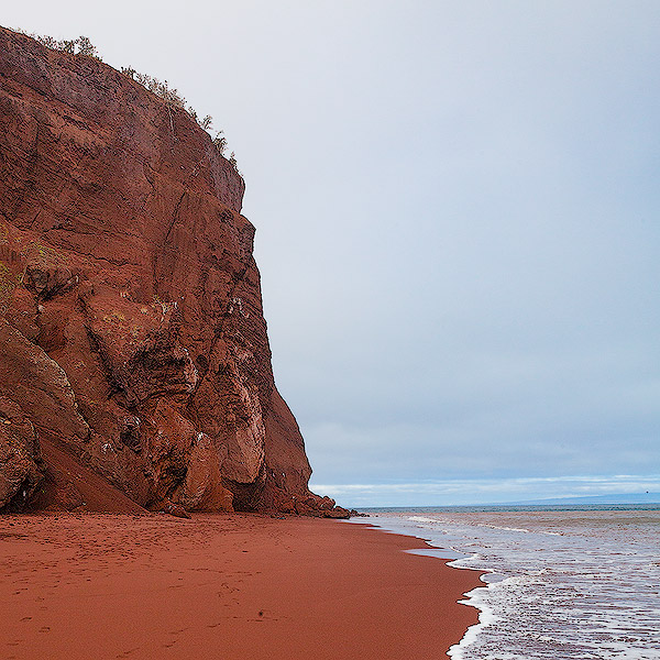
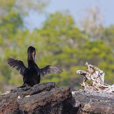
The lava from several volcanoes on Rábida island is rich in iron, which gives the island its distinctive reddish-brown hue. Near the landing site, the red cliffs are home to nesting Blue-footed boobies.
Blue-footed boobies nesting on the cliffs
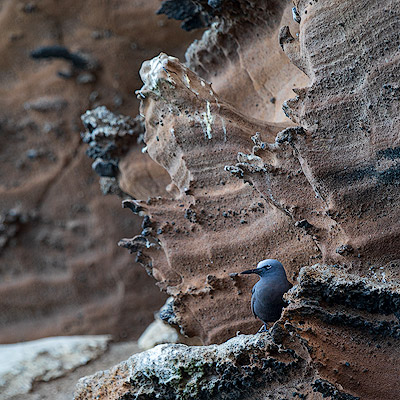
Common Noddy with Prickly Pear Cactus, Rábida Island
The most unique feature of Rábida island is its fine red sand beach. The white waves lap up against the red sand, a beauty that would be ranked on the top among all the beaches of the world.
Red beach of Rábida Island
The sky was clearing somewhat as we climbed the hill to the right of the beach. From here you can clearly see the lagoon behind the beach. The hill is also full of Palo Santo trees.
The lagoon right behind the beach, Rábida Island
As we walked along the path up the hill, it started raining for a while. The red volcanic rocks along the coast were covered with patches of Prickly Pear Cactus, which Marco said they looked like the ears of Mickey Mouse.
The hiking trail of Rábida Island
Cactus on the volcanic rocks
The walkable trails on Rábida Island are not very long. We turned back to the beach in 30 minutes. The beach continues around the hillside. There are sea lions and marine iguanas lying on the beach. Pelicans are nesting on the shore and this is a great place to see them up close.
A pelican nesting on the rock, Rábida Island
Sea lions on the beach, Rábida Island
A lonely marine iguanas on the volcanic rocks, Rábida Island
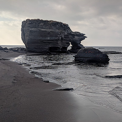
The distinctive red sand beach always adds a charm to the landscape. At the end of the beach is a towering cliff, as if the world ends here.
The rock with unique shape on the beach, Rábida Island
The towering cliff at the end of the beach, Rábida Island
The last thing I have to say is the crew who cleaned our room. Every time we came back from landing, not only were the beds neatly cleaned, but the crew also folded towels into various animal shapes, which shows the crew’s dedication and enthusiasm for their work.
Folded towels in the shape of elephant
We left Rábida Island before lunch. Our next stop is Sombrero Chino.
The Telluride trip was planned at the same time when we went to Jackson Hole in 2018. Because of the schedule and the pandemic, we didn’t got chance to make the trip until this year. Since it was the first time we traveled by air since the pandemic started, we were quite cautious and careful. In Colorado, although almost everyone in the airport and on the plane wore masks, in several local cities, there were few people wearing masks, and the attitude towards pandemic prevention really varies greatly from region to region.
Our flight left California in the morning, connecting in Denver and arriving in Montrose at almost 3 p.m. The view of the Rocky Mountains from the plane was spectacular, but there were not many areas covered with yellow trees. I was a little concerned that we were too early to see the fall colors.
Rocky Mountains
Montrose is about an hour’s drive from Telluride. If you don’t want to drive yourself, there are shuttles take visitors to Telluride. We got a Chevrolet Equinox, which is an urban SUV, and actually cannot go off-road on the many mountain roads in Colorado.
Landing on the Montrose Airport
Montrose Airport
It was intensely sunny outside. I guess it’s almost 80 degrees, and didn’t feel like fall at all. We bought some food and water at Walmart and officially set off.
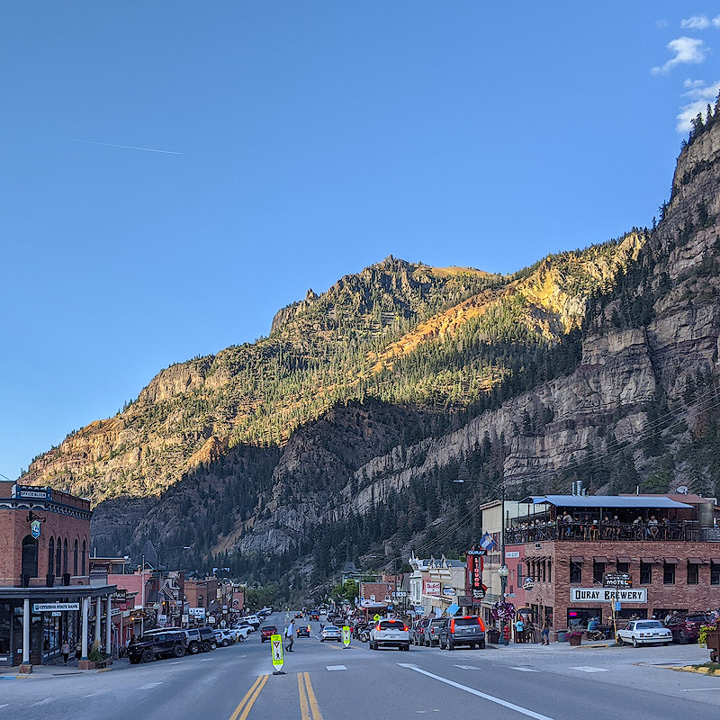
10 more minutes drive after passing Ridgway, we arrived at Ouray. This area was inhabited by the Ute Indian tribe until the arrival of the Europeans. In 1861, with the discovery of gold mines, there was a gradual influx of foreigners. In 1876, the town of Ouray was officially established and named after the chief of the Ute tribe. For nearly 100 years after that, gold and silver mining was the main source of income for the local economy, although there were ups and downs due to the market and regulations. Some mining sites were still in operation even as late as 1990.
Ouray
Ouray
Around 1920, the downturn in the mining industry led the residents of Ouray to look for other ways to make a living. Ouray has been called the “Switzerland of America”, although it is an exaggeration, the natural beauty of the area made tourism a preferred alternative to mining. To attract tourists, Ouray began building a large public swimming pool in 1923, and to this day, the spa pool is a major tourist attraction in Ouray. Interestingly, when the pool was first built, the town claimed that it was the “most radioactive pool” in the United States. At that time, people thought that radioactivity was good for health, but today, this would scare everyone off.
Old Brewery, many doing people watch on the patio.
Most of the existing buildings in Ouray were built in the 1880s to 1890s. We walked around the street, it was almost 6 o’clock, it was a bit late, many stores were already closed, only some souvenir stores and restaurants were still open. We chatted with the owner of a souvenir store for a while, he also loves photography and has a lot of his works for sale hanging on the wall of the store. He told us that the Million Dollar Highway between Ouray and Silverton is a good place to see the fall colors, but the fall in Telluride comes later and the leaves are not yet yellow.
Old buildings on the main street, Ouray
Drive back from Ouray and turn left at Ridgway, we were on our way to Telluride. The elevation rises gradually. Near the top of the mountain, to our left, it’s a meadow field extending to the majestic San Juan Mountains in the distance. I stopped to take a few photos on the side of the road and continued on. The place at the top of the mountain is called Dallas Divide, with the San Juan Mountains to the south and the Uncompahgre Plain to the north. It is the watershed between the Uncompahgre and San Miguel rivers. About one mile away from Dallas Divide, there is a viewpoint surrounded by mountains. Especially on the slow slopes of the San Juan Ridge, yellow aspen and red and brown shrubs are intermingled and colorful, with strong autumn colors overflowing. Many people took pictures here and waited for the sunset. I also lingered here for a long time until way after the sunset, before continuing on my way.
Over look San Juan Mountain, near Dallas Divide
Dallas Divide
After another 40 minutes of driving through the dark valley, we finally arrived at Telluride. We had booked The Auberge Residences for our first night, which are actually private condominiums managed by a company that rents out all sizes of suites. We booked a suit with two roome, but the management couldn’t find our order. Eventually, the owner upgraded us to a two-story four-room suite. The room was very new and decorated like a model room, but unfortunately we were only staying for one night.
The Auberge Residences at Element 52, Telluride
It was almost nine o’clock. We worried that the restaurant would be closed, so the hotel made sure that an Italian restaurant called Rustico was still open and drove us to the restaurant. The restaurant had both indoor and outdoor seating, and it was still crowded. We ordered a pasta and mushroom lamb carpaccio. The food tasted fine, but the service is awful and the waiter was impatient.
Rustico Ristorante, Telluride
Returned to the hotel, we found that the shower faucet could not be turned off after turned on. We called the apartment plumber, thinking that no one would come because it was too late, but at midnight, the plumber did come. After almost half an hour and tried all sorts of means, the water was finally stopped. Overall, it was a smooth day with some hustles in the end.
The sea off Isla Albany was calm and the sun was shining. The lunch was moved to the open space on the second deck.
Lunch at Isla Albany, Santiago Island
The afternoon landing was at Puerto Egas, south of James Bay. It is the best place to see Galápagos Fur Seal. Fur Seal belongs to a subfamily within the sea lion family. They are smaller than sea lions and have a slightly shorter muzzle. It’s really not easy to tell them apart without looking closely. On the rocks along the shore stand a few Yellow-crowned Night-herons, the sea breeze blowing their plumes slightly. The night-herons rarely move, standing alone in the wind is the main thing they do throughout the day.
Galápagos Fur Seal, Puerto Egas, Santiago Island
Yellow-crowned Night-heron, Puerto Egas, Santiago Island
Marco led us walking along the coastline. This section of the coast is formed by volcanic rocks. The sea shore zigzags and the terrain is undulating. Repeated slapping of the waves formed the tide pools in different sizes among the rocks. There is a stone bridge where the waves are strong and the erosion is the most severe. This is one of the unique landmark of Puerto Egas, and everyone took pictures here.
Stone bridge, Puerto Egas, Santiago Island
The erosion created many rock stacks along the shore, some of which are more than half a meter high. They have this layered swirling structure. The dark lava stack with the unique shape covering large area as far as the eye can see. The view gives a rather supernatural feeling.
Puerto Egas, Santiago Island
Puerto Egas, Santiago Island
Marine iguanas and red crabs (Sally Lightfoot crab) were found everywhere. The red stone crab is not endemic to the Galápagos, but can be found on tropical and subtropical seashores throughout the Americas. They are agile and adept climbers, often clinging to the lava rocks. The immature crabs are not as brightly colored, and the night herons and rock herons that stand quietly on the shore are their major natural predators.
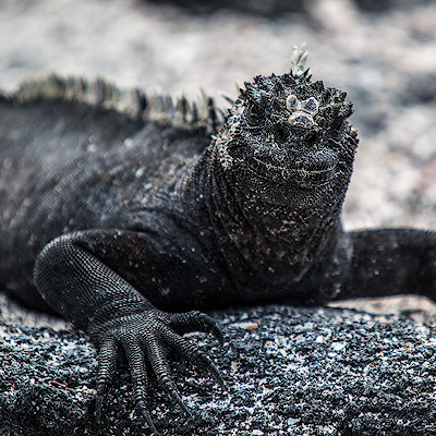
Marine Iguana, Puerto Egas, Santiago Island
Sally Lightfoot Crab, Puerto Egas, Santiago Island
Sally Lightfoot Crab, Puerto Egas, Santiago Island
The beach without volcanic rocks is often covered with a type of vines called beach morning glory. It is also called saddle vine because the opposite leaves along the vine resemble a saddle. Their pink trumpet-shaped flowers are unbelievably beautiful on the barren beach, but more importantly, beach morning glory is saline-tolerant and can prevent sand erosion. It is also used as a herb in China.
Beach Morning Glory, Puerto Egas, Santiago Island
We walked to the southern point of James Bay. The black beach is made by the eroded lava rocks. The rock formation at the end of the beach looks like the All Terrain Walkers (AT-AT) from Star Wars. The mysterious landscape leads us to an alien planet.
Puerto Egas, Santiago Island
We boarded the ship here. From the ship we could see the abandoned buildings on the shore. This was built for the salt mines back in the 1920s. It is said that there is also an open space nearby, which was a soccer field in those days.
Abandoned constructions at Puerto Egas, Santiago Island
Our boat traveled south along the coastline and woud arrive in the evening at Rábida, a small island to the south of Santiago Island.
Itinerary of Playa Espumilla and Puerto Egas, Santiago Island
After a bumpy night, our boat was moored in the early morning off James Bay, Santiago Island. Santiago Island is located northwest of Santa Cruz Island and has been a supply location for whaling ships since the early nineteenth century. Roads and buildings were even built near James Bay in the early twentieth century to extract the salt from the volcano. Introduced species brought by humans have caused great damage to the island’s ecosystem. According to Darwin’s diary, the island was home to a large population of land iguanas, which are now extinct on San Diego Island. Beginning in the 1980s, the project to remove introduced animals from the island was carried out. By the turn of the century, the island was declared pigs, sheep and donkeys free and the island’s ecosystem began to recover. In contrast, some introduced plants began to proliferate because of the disappearance of these animals. They are more difficult to eradicate than the larger animals, so their spread has to be controlled.
Near Espumilla Beach, Santiago Island
The northern landing site of James Bay is at Espumilla Beach, a sandy beach surrounded by mangroves. This is a Galapagos sea turtle nesting site. A few days before we arrived, a turtle had laid eggs in the woods. The guides blocked the path to the forest with tree trunks, telling later visitors not to pass, so we had to walk along the beach.
Espumilla Beach, Santiago Island
Mangroves on the Espumilla Beach, Santiago Island
A number of seabirds can be seen on the beach, and a flock of blue-footed boobies are hunting for food. The blue-footed boobies waddle around on land and make funny moves, but they have a jaw-dropping skill. When they find prey in the water, they suddenly turn their bodies in the air and dive for the water. When they get close to the surface, their bodies almost form a line, and they hit the water like a bolt of lightning. Sometimes nearly a hundred blue-footed boobies are hovering over the water, and when someone calls, all the blue-footed boobies dive almost at the same time. The view is really a wonder of nature.
Since the blue-footed booby preys on fish by diving headlong into the water, their nostrils are closed and they need to breathe through their mouths. Blue-footed boobies have special air sacs in their skulls, and their necks are much thicker than other birds. These body structures protect their heads and necks from damage when they dive into the water at speeds approaching 100 kilometers per hour.
Blue-footed boobies diving, Espumilla Beach, Santiago Island
American Oystercatchers normally walk on beaches and riverbanks, feeding on shellfish and oysters. Their beaks are long and sharp and can pry open shells. Oystercatchers are fast runners and long fliers. I wonder if it’s a lot of trouble for a bird that’s not that big to move with such a long bill. But think about Hummingbirds, who has the longest beak compared to their body, they are actually the most aerobatic flyers.
American Oystercatcher, Espumilla Beach, Santiago Island
Galapagos Mockingbird, Espumilla Beach, Santiago Island
Cabo Cowan is a tuff cone located on the northern rim of James Bay. Years of weathering have eroded one side of the mountain into a cliff, exposing the sedimentary strata inside the mountain. Seabirds have not missed the opportunity to build nests on the layers of rock walls. Lava Gulls and blue-footed boobies can be seen perched on top from a distance.
Cabo Cowan, Santiago Island
Cabo Cowan, Santiago Island
Further north from the crater is the small island called Isla Albany, which is actually a few rocks jutting out of the water from Santiago Island. Isla Albany is a great place to snorkel, because of its complex rock formations and attached coral that provide an ideal place for marine life.
Near Isla Albany, Santiago Island
Near Isla Albany, Santiago Island
Near Isla Albany, Santiago Island
Instead of going snorkeling with the others, I lay on a deck chair at the top of the boat and read a book. Traveling on a cruise is a great opportunity to read, with a ton of time and not much to do, and often books that haven’t made much progress in months can be completed in one trip. This time, I brought “Guns, Germs, and Steel”, a book that has been recommended by many and is indeed a masterpiece. While telling the story of the grand history of mankind, Jared Diamond supports his theories with great amount of details and discoveries in geography and archaeology, reasoning and deriving theories step by step. It is an inspiring and rewarding experience.
Lying alone on the top deck, the only thing I could see are a few rocks on the calm sea, the only sound I could hear is the creaking as the boat swaying around with the breeze. It was as if I was the only one left in the world.
During lunch time, the yacht returned from Fernandina Island to Isabela Island. The yacht docked at Punta Vicente Roca, which is located at the mouth of seahorse-shaped Isabela Island. The western side of the Ecuadorian volcano collapsed into the sea, leaving only half of the mountain attached to the island. Ecuadorian volcano is the smallest among the six volcanoes on Isabela Island.
Itinerary for Punta Espinoza, Fernandina Island and Punta Vicente Roca, Isabela Island
Punta Vicente Roca is a good place for snorkeling because it is located near the equator, where wildlife converge because several ocean currents meet here. After lunch, we first dived in the bay near the crater, probably because there are more plankton, the water here is not very clear. There are many sea turtles, almost within reach.
When it comes to the diversity and uniqueness of the flora and fauna of the Galápagos Islands, it is important to talk about the geographical location and geography of the islands. Like Hawaii and Tahiti, the Galápagos Islands are volcanic islands. Instead of being located where the earth’s plates meet, these islands are in the central part of the plates. The popular explanation for the high volcanic activity is attributed to the hotspots in the Earth’s mantle, and the Galápagos Islands are on top of such a hotspot. The release of energy from the hotspot causes the formation of volcanoes, and the eruptions form islands that move eastward with the plate they are on. Therefore, the eastern islands of the Galapagos Islands are more ancient, and the western-most Fernandina Island is the youngest, only about seven hundred thousand years old.
The newly formed islands had intense volcanic activity, the soil was infertile. The surface was mostly covered with volcanic rocks and it was difficult for plants to survive. As the altitude of volcano increased, precipitation increased; the accumulation of plants and animals also slowly improved the soil, and forests gradually formed in the higher elevations of the mountains. Santa Cruz Island is representative of this type of island in the intermediate stage. The eastward shift of the plate took the island out of the hotspot and volcanic activity stopped. Because of self-weight and weathering, the volcanoes gradually collapsed and slowly sank into the sea. This is the fate of all the islands of the Galápagos Islands, and the whole process took about two to three million years.
Hotspot under the Galápagos islands, from BBC.
Volcanic remains as far back as 7 or 8 million years have also been found underwater further southeast in the Galápagos Islands, and the emergence of islands in this region may be as far back as tens of millions of years. The volcanic islands were separated by seawater, allowing species to evolve independently; and the islands were not so far apart that a small number of plants and animals were able to migrate to the emerging islands and begin a new evolutionary process. Those islands that sank to the bottom of the sea did not stop evolving; they provided nutrients and habitat for marine life.
Punta Vicente Roca
After the snorkeling, we took a short break and reboarded the zodiac. The zodiac departed from the southern end of the crater and slowly floated south along the rocky shore wall. There were several pairs of Nazca Boobies, some with their young, on the rocks jutting out from the shore. It’s just a pity that the wind and waves were too strong here and the zodiac undulates so much that it’s hard to get a clear picture.
Nazca Boobies
As the zodiac continued south, the rock walls here are made of layers of volcanic rocks. Various birds are nesting and landing on this steep rock wall.
Lava Gull
Blue-footed Booby
Common Noddy
Marine Iguana on the rock wall
There is a large cavern in the small bay on the south side of the crater, probably formed by the flow of magma, similar to a lava tunnel.
Volcanic cavern, Punta Vicente Roca
Such top-to-bottom cracks can often be seen in the rock walls, which are vertical faults between rocks. The volcanic activity caused the fault to split and the magma to pour in, creating such a geological structure. The intensity of volcanic activity in this area is evident.
Vertical faults between rocks, Punta Vicente Roca
Leaving Punta Vicente Roca, we’re heading back to the central islands of the archipelago tonight, circling around Seahorse Head of Isabela Island. The boat would cross the equator as it headed north. It is a tradition for ships on long voyages to hold a ceremony for the crew of the ship crossing the equator for the first time. Like a Halloween celebration, the crew dresses up in fancy costumes, usually with someone dressed as Neptune, and there are often crazy antics during these ceremonies.
The location of the Galápagos Islands also contributes to its diversity of species. The Cromwell Current, also known as the Equatorial Current, is an ocean current that runs west to east across the Pacific Ocean at about 100 meters below the surface. Cold currents from the Panama Basin in North America and Peru in South America meet the Cromwell Current at the Galapagos Islands, which are located on the equator. The cold currents rise to the surface when they reach the islands, bringing large numbers of microorganisms to the surface and nourishing the life in the waters around the islands. In some years, for unknown reasons, these cold currents weaken, causing the temperature of the sea surface to rise, and an El Niño phenomenon is formed.
Currents near the Galápagos Islands, from BBC
Traditions need to be observed, but of course our celebration was much more civilized. Everyone on board gathered in the cockpit of the boat, Marco poured a glass of champagne for everyone, and we gathered around the GPS device, waiting for the moment of crossing. When the number on the panel jumped to zero, everyone broke out in cheers. After the celebration, the captain also let the young boys on board to drive the boat himself.
Equater Crossing
The sun is gradually setting at sea level. Tonight the boat will sail out of the area surrounded by islands again. It will be a bumpy night.
In the morning, the boat was moored in the calm water near Punta Espinoza. The sun was shining through the dense clouds, adding a sense of sanctity.
Near Punta Espinoza, Fernandina Island
There is a section of stone stairs for boats to dock at the Punta Espinoza. Fernandina Island’s volcano is highly active, with La Cumbre had erupted the year before we arrived and again in January 2020. Punta Espinoza is probably the only place where visitors can board the island. Because there have been no humans living on the island, Fernandina is also the only island free of invasive species.
Punta Espinoza landing site, Fernandina Island
The volcanic rocks run from the foot of La Cumbre to the sea, with a sandy beach in between. Large gatherings of marine iguanas could be seen everywhere, some of them occupying the paths marked out for visitors to. We had to pass by carefully, not daring to disturb these little sunbathing dinosaurs.
If you looked closely, you’d find that some marine iguanas nod their heads and spray something between their nostrils from time to time. It turns out that marine iguanas go down to the sea to feed on moss and bask in the sun on the shore, and over time, salt from the seawater will gather in their bodies. Like other marine reptiles, there is a gland near the nasal cavity of marine iguana that can filter the salt in the blood and then discharge it from the nostrils to maintain the balance of salt in the body. The sprayed salt falls on the top of the marine iguana’s head, just like with a white hat, which is very comical.
The skeletons of dead marine iguanas can be seen on the beach. In addition to the change of body form, marine iguanas have a special skill of adapting to the environment. In the years when the El Niño phenomenon is severe, the marine iguanas have less food because of the increase in seawater temperature. If the El Niño lasts for a long time, it will cause a large number of marine iguanas to die. At this time, the marine iguana will not only reduce feeding and weight, but even shrink the length of its body by more than 20% until the water temperature returns to normal and the food is sufficient. Such a process will happen many times in the life of a marine iguana.
Fernandina Island is covered almost entirely with volcanic rock from La Cumbre volcano to the sea. Except for the mangroves on the beach, only the lava cactus can take root from the barren volcanic rock.
La Cumbre Volcano, Punta Espinoza, Fernandina Island
Lava cactus, Punta Espinoza, Fernandina Island
We walked along the shoreline to a small bay surrounded by mangroves. The narrow bay extends deep into the land, and the water is shallow and crystal clear. This is a quiet and secluded place. The calm waters also attract marine animals to inhabit here. Several sea turtles can be seen here and there. Some were crouching on the shore, while others were crawling in the water very close to us.
Green turtle, Punta Espinoza, Fernandina Island
Green turtle, Punta Espinoza, Fernandina Island
Roots of mangroves, Punta Espinoza, Fernandina Island
Back on the yacht, just after a short rest in the room, we heard the crew calling everyone outside the cabin door. It turned out the crew discovered a school of dolphins passing by not far from us. Marco and the crew decided to go after the dolphins. We put on the life jackets and boarded the zodiacs, which accelerated to the direction of the dolphins.
Within minutes, we caught up with the dolphins. It was definitely the most spectacular scene we have ever seen. We were surrounded by nearly 100 dolphins and sea lions speeding forward with us. Usually two or three dolphins were swimming side by side, riding the waves, playing and cheering. They burst out of the sea, drawing a beautiful arc, and then submerged in the water.
Chasing dolphins, Punta Espinoza, Fernandina Island
After about 15 minutes, the dolphins swam away. After the quiet and calm time around the shallows water of the bay, we also experienced the excitement of chasing dolphins. What a good time in the morning!
It is only about 10 nautical miles to cross the channel between the two islands from Punta Mangle on Fernandina Island to Bahía Urbina on Isabela Island. Our yacht arrived in the late afternoon and was anchored in the sea near Isabela Island.
The next morning’s landing site was Urbina Bay, a half-moon shaped beach. This area was below sea level until 1954, when crustal activity caused the surface to rise five meters overnight, pushing the coastline outward by more than a thousand meters. the beach at Urbina Bay is dark black, and many shells and rounded stones can be seen, showing that it has not been exposed to the water for long. The geological activities on Isabela Island are still very active.
Bahía Urbina, Isabela Island
Sea lion’s spine, Bahía Urbina, Isabela Island
The half-moon shaped beach is surrounded by bushes and we followed the trail deeper into the trees. Throughout the Galapagos Islands, Bahía Urbina is the only place where giant tortoises are still lived naturally, while elsewhere they are mostly affected by migrations and invasive species. On the paths we walked, we could see tracks of giant tortoises and their excrement left behind. The small apples that they eat contain substances that are toxic to humans, but they are not only harmless to the turtles, they also help them digest other foods.
Bahía Urbina, Isabela Island
Giant Tortoise’ excrement,Bahía Urbina, Isabela Island
Not long into the walk, we saw an giant tortoise coming head-on toward us. Our group immediately stepped to the side to give way to the tortoise. The giant tortoise did not seem to be bothered by our presence, still walking unhurriedly in front of us, and occasionally looked up at us, as if reviewing the team to salute it.
The giant tortoises walk slowly and don’t work very fall. Those living in different parts of the archipelago have evolved independently and have developed different body forms due to environmental differences. In arid areas, where there is a lack of vegetation on the ground, tortoises must hold their heads up to eat leaves from cacti or shrubs. The heavy shell of the tortoise becomes a burden and needs to make way for the raised neck. Over time, the front of the back of the tortoise has evolved into a saddle-shaped bulge. The tortoises that live near Bahía Urbina apparently do not require this much effort, and their shells are still relatively flat and round. The following picture is displayed on the wall of the tortoise farm we visited on our first day. It depicts the shape of tortoises’ shell in different parts of the Galapagos Islands. This is one of the most important pieces of evidence to support the theory of natural evolution.
Giant tortoise distribution
We followed the trail for about one and half miles to the top of the hill and back, seeing a variety of plants and animals unique to the Galapagos Islands along the way. Interestingly, the majority of the wildflowers in the archipelago are yellow, again as a result of natural selection. There is only one type of bee on the Galapagos Islands, the Galapagos carpenter bee, and they are only interested in yellow flowers, so the flowers on the islands do not have to be colorful, and only plants with yellow flowers are survived over generations.
On the way back, we saw a land iguana lying on the side of the road. There are three species of land iguanas in the Galápagos Islands, besides the Galápagos land iguana we saw, the land iguana that lives on Santa Fe Island, and the pink land iguana that was found after 1986 at Volcán Wolf, north of Isabela Island. The Galapagos land iguana has a yellowish body and a more prominent mouth than the marine iguana, and feeds mainly on cactus and leaves. According to recent studies, the land iguana and the marine iguana separated about 4.5 million years ago. Since humans moved into the islands, invasive species, such as feral cats and dogs, brought by humans have posed a great threat to the survival of the land iguana, and the naturally growing land iguana on some islands has become extinct.
Galápagos land iguana,Bahía Urbina, Isabela Island
When people talk about the Galapagos Islands, they often think of marine iguanas and giant tortoises. The unique physical appearance of these animals did provide strong evidence for Darwin’s theory of natural selection, but it was the unimpressive finches that really inspired Darwin’s discovery. It is said that although Darwin collected many specimens of finches in the Galapagos Islands, he himself did not pay much attention to them and did not even record them in his diary. It was not until after his return to England that a painter named John Gould depicted and classified these specimens as belonging to different species. It was only then that Darwin began to organize these finch specimens, tracing the locations where they were collected, which eventually inspired his theory of the evolution by natural selection.
At noon, the boat left Bahía Urbina for Caleta Tagus. There were several frigatebirds flying with the boat with the help of the wind. Frigate birds are large, and the males have red throat sacs on their necks that can rise to a balloon-like, reddish color during breeding. Now that the season is not right, the red throat is just deflated and attached to the frigatebird’s neck.
The Frigatebird following the boat, en route to Caleta Tagus
Caleta Tagus is a bay with calm winds and waves. The first activity after lunch is kayaking.
Kayaking at Caleta Tagus, Isabela Island
Caleta Tagus is located at the foot of Darwin Volcano. Because of the calm waters, this was once a regular resting place for pirate ships and whaling boats. The place where we landed not only has stone steps carved out of the rocky shore, but also several sections of wooden handrails. On the cliff face by the “port”, the captains carved the year and their boats’ name on the rock, some can be dated to as early as 1800. As our guide Marco said, the Galapagos Islands National Park was established in 1959, before that, the carvings on the rocks are history; after that, they are graffiti.
Caleta Tagus, Isabela Island
We walked up the trail and then along the ridge of Lake Darwin Crater again. In addition to Darwin Volcano, there are actually several smaller craters around Caleta Tagus. As we walked up the ridge and looked back, we could overlook the bay and Lake Darwin separated by the narrow crater ridge. Lake Darwin is twice as salty as sea water and there is little life in the lake. Nearby are a few Palo Santo trees, a unique sight against the turquoise blue water of the lake.
Lake Darwin, Caleta Tagus, Isabela Island
The Palo Santo tree grows widely in Central and South America and is known as a sacred tree. the wood of the Palo Santo tree contains natural oils and aromas and was often used for rituals in the past and is now also used as incense for its refreshing effect. the slopes around Caleta Tagus are covered with Palo Santo trees, the top branches of which resemble an umbrella. They are especially beautiful as they as covered the entire hillside.
Palo Santo tree, Caleta Tagus, Isabela Island
Palo Santo tree, Caleta Tagus, Isabela Island
The end of the trail brought us to the western slope of Darwin Volcano and a large area of volcanic land. It was quite hazy that late afternoon. We couldn’t really see it from a distance.
The western slope of Darwin Volcano, Caleta Tagus, Isabela Island
It was dark when we were back at the boarding area. There were several sea lions on the rocks by the beach, and one of the baby sea lions was staying in the middle of the steps. This was the third day of our trip and we had seen all the animals we were supposed to see. Will there be more surprises to come?
During lunch time, the yacht sailed from Punta Moreno on Isabela Island to Punta Mangle on Fernandina Island, the westernmost and youngest island in the Galapagos Islands. Because of the active volcanic activity, there is little vegetation on the island. The island is completely covered with volcanic rock. Punta Mangel is a a natural inlet with calm waters surrounded by the mangrove forests. It provides shelters for both marine animals and birds.
Our boat cruised slowly along the coast. There were hundreds of marine iguanas crawling on a rock by the shore. Among them, there was a Flightless Cormorant, hatching baby birds. He barked loudly when he saw us coming, not sure if he was warning strangers approaching or complaining at being surrounded by a group of “monsters”.
Flightless Cormorant surrounded by Marine Iguanas,Punta Mangle
The ancestors of marine iguanas originated in South America and probably reached the Galapagos Islands by drifting for months on tree trunks. Through long-time evolution, the marine iguana’s body has adapted to island life. Although they are clumsy on land, they are very nimble in the sea. Not only can they swim but also dive. Underwater they can hold their breath for an hour and dive 20 meters. Compared with their land-based counterparts, marine iguanas’ mouths become shorter and more rounded at the front, making it easier for them to eat algae attached to rocks. Their tail is thick and strong, which is a propeller for swimming in the water.
Marine Iguanas,Punta Mangle
Marine Iguanas,Punta Mangle
A Galápagos Eagle can be seen on the shrub branch on the shore, Marco says, most of the islands’ flora and fauna originated on the mainland and evolved over time to become endemic species. They are commonly named in one of three ways: prefixing Galápagos-, or Darwin-, or Lava-. Interestingly, after DNA analysis, the Galápagos eagle is a close relative of the Swainson’s Eagle , which started living in Galápagos about 300,000 years ago, which makes it the latest animals to arrive in the archipelago.
Galapagos hawk,Punta Mangle
Galapagos Sea Lion,Punta Mangle
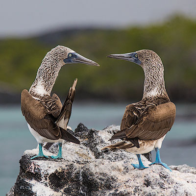
Blue-footed booby can be found throughout the tropical waters of western America, but half of them nest in Galápagos. Blue-footed boobies are comical looking and their most obvious feature is of course their large blue feet. The males use their feet to attract females. The brighter the blue, the more likely the male is to be favored by the female.
There were a few blue-footed boobies standing on the rocks at the beach. We happened to witness a male booby wooing the female. The male gradually moved closer to the female, lifting their feet back and forth as if to prove that they had the brightest color. Then the male arched his back and stirred his wings to attract the female’s attention. Unfortunately, the female seemed uninterested and unmoved.
Blue-footed boobies,Punta Mangle
Blue-footed boobies,Punta Mangle
Galapagos Heron,Punta Mangle
The zodiac sailed into a small inlet bay surrounded by mangroves. Mangroves are able to grow in high salinity water, so they are often found in wetlands along tropical and subtropical seashores, and sometimes grow into forest.
Mangrove is a amazing plant. Usually the seeds of plants are embedded in the fruit. When the fruit falls to the ground and rots then the seeds germinate and grow. But mangrove fruits do not fall off after ripening, and the seeds in them start to grow until they become 20 to 30 cm long. This mechanism to help their seeds to survive is called viviparous. The propagule then drops into the water. It has a similar density to seawater and can floats with the waves to great distance. When the propagule has absorbed enough water, the roots become heavier and it floats vertically in the water. When the tide fades, it can plant itself into the mud and grow into new plant. This cycle repeats itself, and soon the entire mudflat area will be covered with mangroves. Because mangroves grow on the shore, which is frequently flooded by waves, they are generally not very tall and their roots cannot be planted very deep, but they do have well-developed root-like branches that are inserted into the shallows to keep the plants stable. The stilt roots above the soil are exposed at low tide and can absorb oxygen from the air. These distinctive characteristics give mangroves a competitive advantage over other terrestrial plants in the shallow coast.
Mangroves,Punta Mangle
The water in the bay was very calm. There were a few sea lions swimming and playing in the bay and making occasional whimpering sounds. The zodiac took us cruising among the mangroves. When we returned to the boat, we passed through the bottom of the yacht. Our boat is a catamaran structure. The zodiac had no difficulty passing between the two hulls.
Before dinner, Marco introduced us to the entire crew of Seaman Journey. There are only 11 passengers on board, but there are 9 crew members including the guide. Through the narrow hatch and ladder, you can reach the bottom of the boat where the crews were living. The space is quite confined.
From Santa Cruz Island to Isabela and Fernandina islands, we had to sail out of the area surrounded by the archipelago to the outer sea, where the wind and waves are stronger. Our boat was much smaller than the one in Antarctica, so it felt very bumpy on the rough water. Fortunately, we took anti-seasickness medication first and slept through the night.
The next morning we woke up to calm seas and the yacht was anchored on the west side of Isabela Island. Our yacht has four levels, with the crew cabins, galley and machinery room at the bottom. Visitors live on the first level, which is also the main public area and dining room. The second level is the cockpit, high-end guest rooms and open space where meals can be served when the sea is calm. The top floor is the observation deck with sofas and loungers.
The open space on the second level of the yacht
The observation deck on the third level
Isabela Island is the largest island in the archipelago, shaped like a seahorse, formed by six volcanic eruptions that connect the land. Five of the six volcanoes are active, including Sierra Negra, the largest of all the Galapagos Islands volcanoes, with a crater nine kilometers in diameter. It was actually erupting while we were there, but it would take a few days more before the lava would spew out. Isabela has permanent residents, mostly in Puerto Villamil on the south coast, and land-based visitors often stay overnight in Puerto Villamil to participate in the island’s various activities, including climbing of Sierra Negra volcano.
Marco wrote the daily itinerary on a whiteboard. The morning activity was hiking on the island, followed by snorkeling. The place we boarded was Punta Moreno, located on the south side of Isabela Island, at the tail of the seahorse.
Before going ashore, we saw one of the most famous animal of Galápagos, the marine iguana. They like to gather by the dozens or hundreds when they are sunbathing on the rocks, crowding together and stepping on with each other. Perhaps because humans have never posed a threat to them, marine iguanas are not afraid of people. Even we walked by closely, they seemed paying no attention and do not move at all.
The marine iguanas baking on the rock
Punta Moreno’s landing site is a great place to observe a variety of seabirds. Just as we were about to dock, a black and white figure appeared on a reef near the shore. While most penguins live in or near the Antarctic, Galápagos penguins can survive near the equator because the cold current from Peru and the Cromwell Current below the surface of the ocean meet here, where the water temperature is much cooler than in other equatorial regions. The size of Galápagos penguins are less than 50 cm. Only the Little Penguin, which lives on the south coast of Australia and New Zealand, is smaller than them.
A Galápagos penguin
On the volcanic rocks by the shore, we see another bird endemic to the Galápagos Islands, the Flightless Cormorant. The Flightless Cormorant lives on the west coast of Fernandina and Isabela islands, feeding on small fish and octopus and rarely leaving the shore. Because they have adapted to feeding on fish in the sea, their wings are slowly degenerating and the keel that support the flapping of their wings are getting smaller and smaller. They are no longer able to fly, but they have become good divers.
Flightless Cormorant
Punta Moreno is a large area of volcanic lava field dotted by lagoons. Most of the vegetation is concentrated in the mangroves along the sea and areas around the lagoons.
Mangroves and lava fields
Lagoon in the lave fields
The volcanic rocks of the Galápagos Islands are rich in basalt. Instead of explosions of gas and ash high into the sky, eruptions tend to discharge molten lava flowing slowly, much like the volcanoes of Hawaii. There are two main forms of lava flow. The faster flowing lava is called ‘a’a (hurt), which forms a jagged rocks as it cools; the other type of lava flow, pahoehoe (ropy), moves much more slowly and cools to a relatively smooth surface with a twisted texture, hence the name “ropy”. Lava field in Punta Moreno are mostly of ‘a’a type. There are sharply edged volcanic rocks everywhere, so you have to be extra careful when walking.
Jagged lava fields
Fractures of lava rocks
Some lava fields are of pahoehoe type
The barren lava fields have no water to support anything, but there are always plants that have managed to take root among the volcanic rocks. All three species of cactus unique to Galápagos can be found in Punta Moreno. Little by little they change the composition of the soil, and over time, when water is available, large areas of vegetations will grow here.
Thin Leafed Darwin’s Shrub
Candelabra Cactus
Prickly Pear Cactus
Lava Cactus
As we walked among the dry lava, Marco explained the landscape, flora and fauna of the surrounding area. The occasional lagoons not only support water plants and shrubs, but also provide a place for birds to enjoy. We found two pairs of flamingos in one of the larger lagoons. The flamingos in Galápagos are small and not very numerous. From March to July is the breeding season and it is easier to spot them at such lagoons.