Close Up of Flowers – Filoli
Shooting macro with Fujifilm x100s at Filoli.
[justified_image_grid preset=c1 ng_gallery=88]
0 Comments
June 2, 2016

Shooting macro with Fujifilm x100s at Filoli.
[justified_image_grid preset=c1 ng_gallery=88]
2014.11.1今天上午的计划是登巴黎圣母院的钟楼。前一天在旅馆吃早饭的时候,墙上悬挂的照片吸引了我。那是西岱岛和圣路易岛在晨曦中的景象,清冷、安静,却令人神往,让我也忍不住想试一下。
早晨七点从旅馆出发,沿着塞纳河边一路上行,走过大主教桥,前方就是圣路易岛。圣路易岛上名胜不多,以住宅区为主。岛的西端面向左岸的一侧是一排临河的住宅楼,河畔是一列耸立的桦树,是一处常常出现在照片里的景致。这里河岸的人行道很宽,有几处可以驳船的码头。前一天是万圣节,大概也是有人庆祝的,河畔上很多酒瓶的碎片。我在这里照了几张照片,但是都不太满意。大概是取景角度太低,而且也没有那种清冷的感觉。


吃过早饭,我们于九点半赶到巴黎圣母院,排队等待登上钟楼。在我们前面大约有三十几个人。十点钟楼开门,一次大概放进十几个人;到十点二十左右,终于轮到我们。

从北钟楼的入口沿螺旋形的楼梯上行,就到达两座钟楼底部的走廊。这里距离地面46米,巴黎的全景尽收眼底。天空万里无云,虽然不适合摄影,但是正合适远眺。从左到右可以看到的著名景点有,圣叙尔比斯教堂、荣军院、埃菲尔铁塔、拉德方斯新区、圣礼拜堂、歌剧院、圣厄斯塔什教堂、圣心教堂和圣雅各伯塔。

这一条连接南北钟楼的走廊上最有名的要算是栏杆转角处的怪兽雕塑。它们栖息于钟楼之上,用最好的视角注视着千年来这座城市的事世变迁。由于早晨逆光的缘故,怪兽在照片里都比较暗,也许在傍晚或阴天的时候才更适合拍照。走廊很窄,上方有钢丝网保护。栏杆上雕刻的花饰、卷叶,以及探出的引水兽处处可见。


我们在这一层停留了大约半个小时,然后从另一侧沿着南侧钟楼内的螺旋楼梯登上钟楼的最顶层。钟楼呈方形,中间是隆起的尖顶,四周可以供游人远眺。


从早晨开始排队到游览完毕,大约花了两个小时的时间。我本来对地标建筑登高兴趣不大,但是有蜿蜒的塞纳河美景,又从不同的视角欣赏巴黎丰富的人文景观,登巴黎圣母院塔顶远眺绝对值得一游。
从巴黎圣母院出来,老婆回旅馆顺路购物,我先在圣母院广场又逗留了一会儿,然后准备去蓬皮杜文化中心那边转一圈。


穿过Pont d’Arcole,进入巴黎的第四区。巴黎的右岸一直为政府和贵族所占据。果不其然,过桥后右侧立刻就是巴黎市政厅(Hôtel de Ville)。巴黎市政府从1357年搬到这里,650多年来就再也没挪过地方。继续向北,又是巴黎典型的商业街道。路上行人不少,倒也不算很繁华。再走两个街区,就到了蓬皮杜中心。巴黎市中心的主要景点距离并不远。

蓬皮杜中心以暴露在建筑之外的彩色管线闻名。除了现代艺术博物馆,还包括一个图书馆和音乐声学研究中心。其建筑设计颠覆传统,与巴黎古式的风格毫不搭界,兴建初期争议很大。不过这样的例子在巴黎的建筑中并不少见,埃菲尔铁塔和卢浮宫前的金字塔都是明证,而且都已经成为经典。这一次我们没有计划参观现代艺术博物馆,我只是在外面转了一圈,反而觉得紧邻的斯特拉文斯基喷泉(Stravinsky Fountain)更有意思。

斯特拉文斯基喷泉是蓬皮杜中心边的一个大水池,其中点缀着十几座色彩鲜艳的雕塑,或旋转或喷水,代表俄罗斯作曲家斯特拉文斯基(Igor Stravinsky)不同的作品。远处占满整面墙壁的是Jef Aérosol的街画作品,“Chuuuttt”。作者这幅画的意思是希望我们能够花几分钟的时间,透过城市工业的喧嚣,聆听人类自己生活的声音。喷泉后面另一侧是圣梅里教堂(Saint-Merri)。教堂看起来颇为老旧,后来才知道它最近还上了世界文化遗址基金会的濒危建筑名单。教堂外壁在绚丽的喷泉雕塑和诙谐的壁画映衬下显得更为晦暗。

走出蓬皮杜中心附近的小巷,Boulevard de Sébastopol是穿过巴黎市中心的南北向大路。它的起点是位于塞纳河边的沙特莱广场(Place du Châtelet)。其中央的棕榈喷泉(Fontaine du Palmier)和胜利纪念柱是由拿破仑下令修建,用以昭示他在法国对外战争中的赫赫战功。广场的斜对面是圣雅各伯塔,法国大革命前是周围屠户修建的教堂,在法国大革命中教堂被拆除,只留下雕饰精美的塔楼。


与沙特莱广场隔河相望的是位于西岱岛上的巴黎古监狱(Conciergerie),连接两岸的是Pont au Change。早在12世纪,这座桥上就有珠宝商和货币兑换所的商店,桥也因此而得名。Conciergerie中世纪时是法国皇家的城堡,14世纪改用为监狱。作为巴黎最大的监狱,特别是在法国大革命时期,关押过不少大人物。建筑靠近塞纳河的一侧塔楼上,悬挂着一座金光闪闪、美奂美伦的大钟,这是巴黎最古老的公共时钟。


回到旅馆再出来吃午饭已经是下午两点。我们选了西岱岛上新桥边的一家小餐馆,La Taverne D’Henri IV。他家店面很小,走到门口我还不能确定是这一家。咸肉拼盘看起来很诱人,味道也很好。


吃过饭的计划是乘BatoBus去埃菲尔铁塔。午饭时喝了点儿酒,在下午和煦的阳光下不禁有些微醺,也没多想就登上了新桥下出发的塞纳河游船。这也让我们有了一次计划之外又是意料之中的塞纳河之旅。
游船上有广播介绍经过的桥梁和岸边的名胜风景,但是一路并不停船靠岸。从新桥出发,游船先是顺流而下,一直到埃菲尔铁塔,在德比尔哈克姆桥(Pont de Bir-Hakeim)调头。


游船随塞纳河上行,到达新桥时,从西岱岛和圣路易岛的左岸一侧继续前行。我们在网上看到的塞纳河游船的视频,大多是天气阴霾,甚至淫雨霏霏,可见遇到个好天气并不容易。而我们在巴黎多雨的季节,却有个不可多得的晴天。两岸黃色亮眼的梧桐掩映着乳白色的古老建筑,游人在河边岸旁闲坐,船上船下的人都是无比的惬意。


到达奥斯特里茨桥,游船折返,再从西岱岛和圣路易岛的右岸一侧回到新桥终点。


下了船,转头再去做BatoBus,原来BatoBus的登船地点是在右岸新桥下面的河边。BatoBus成人票一天16欧元,两天18欧元,比我们刚刚乘做的Vedettes du Pont Neuf游船还贵,坐的很满,完全不如地铁划算。如果乘船游览塞纳河是必须的旅游项目,建议乘坐专门的游船,再乘地铁去往各个游览点。
BatoBus的路线和Vedettes du Pont Neuf游船一致,但是全程有八个停靠码头,在埃菲尔铁塔脚下就有一站。时间已是下午五点,天色已暗,但是埃菲尔铁塔周围还是很热闹。

等待登塔的游人几乎把埃菲尔铁塔正下方的广场挤得满满当当,草坪上也是人满为患,再加上横七竖八的栏杆,我们走出很远也没有找到适合照相的机会。我们走到草坪一侧布尔多奈大道(L’avenue de La Bourdonnais)上的Le Dôme坐下来喝了一点儿咖啡,店员是一如既往的爱搭不理。休息片刻,再走回埃菲尔铁塔,仍然是灯火通明,人声鼎沸。埃菲尔铁塔登塔的时间一直到午夜,但是九、十点钟就会停止售票。

我们走过耶拿桥到夏乐宫的一侧,这里是远望埃菲尔铁塔最好的地点。每到整点,埃菲尔铁塔会在黄色灯光的背景下,闪烁起千万盏银白色的小灯,持续几分钟,为这个热闹的景点再增添几分活力。

我们沿着塞纳河走到德比利行人桥(Passerelle Debilly),又回到左岸。前面不远就是地铁C线在阿尔玛桥(Pont de l’Alma)的一站。地面上的站台只是一间小屋子,幸好有人指点,我们买了回程的地铁票。二十分钟时间就在圣米歇尔(Saint-Michel)站下车回到旅馆,每人只要1.7欧元,非常方便。

2016.2.11~13First-time visit San Diego downtown, Gaslamp Quarter. What a vibrant town at the night!


2015.12.24This street in San Carlos has the best Christmas light of the valley.
[justified_image_grid orderby=date_asc preset=c1 ng_gallery=87]
2014.10.31We had planed to see Notre-Dame in the morning. After having breakfast at the hotel, we were on our way at 8am. Place Saint-Michel was very quiet in the early morning, barely saw anyone there; but it’s a busy place during the day, where French like to meet. On the right side of the following picture, is Fontaine Saint-Michel. Given its popularity, I feel that it requires some maintenance to say the least. With so many people around it during the day, it’s not looking good in the picture.

Cathedral of Notre Dame is located at the east end of Île de la Cité. The construction started in 1163. From choir to nave to the western Façade, it’s 90 years later when two towers were built. After that, the north and south transepts were redesigned and flying buttresses were added, plus remaining touches and elements, it took over 180 years for the Cathedral to be fully completed. The cathedral opens at 8 am, there were not many visitors yet. Notre Dame’s western Façade is famous for its well-proportioned imposing presence and exquisite carvings and statues; but the interior is quite simple.


Talked with the keeper, we learned that the tower wouldn’t open until 10 o’clock and now it’s not even 9 yet. We decided to see Panthéon first. The distance between Notre Dame and Panthéon is only 1 km, we just need follow Rue Saint-Jacques. On our way, we passed the backdoor of Sorbonne, but the entrance was jammed with trash bins and traffic cones. I couldn’t even take a picture.

Panthéon is located in the center of an oval plaza. We first walked to a small plaza in triangle shape at its back. Here sits a small church called Saint-Étienne-du-Mont. Several churches had been constructed on this location in the past 1500 years. The latest one was completed in 17th century to honor St. Geneviève, who in the legend protected Paris from destroyed by Huns. Her shrine is located in the church. Pascal and Jean Racine were also buried here. The building combines different architecture styles, rose window in Gothic and the nave in Renaissance. One of the most famous features in the church is the rood loft with delicate carvings left no surface untouched. It’s said to be one of kind in Europe. Unfortunately, we came to early, the church was not open yet.

Those who have seen movie “Midnight in Paris” should recognize this location. Gil was sitting on those stairs, picked up by an old car and his fantasy time travel started there.


We circled around the small street around the plaza and returned to the Panthéon. Panthéon was constructed at the end of the 18th century. It was originally planed to replace Abbey of St. Genevieve on the same site, but as the construction completed, it’s the time that French Revolution started. The church was repurposed as the place dedicated to the great intellectuals of France. Voltaire, Rousseau, Hugo, Zola, Marie Curie were all buried here. It’s a building in neoclassical style, with its façade modeling Pantheon in Rome. With its dome 70 meters in height, Foucault performed its famous Foucault pendulum experiment here in 1851 to demonstrate the rotation of the earth.


We strolled back along Rue Saint-Jacques as the street began to stir with life. We stopped for a coffee and picked up a few small souvenirs along the way.


By the time we returned to Notre-Dame, it was nearly 11:00 AM. A long queue of tourists waiting to climb the towers lined along the right side of the cathedral. Since we had two more nights on the Left Bank, there was still plenty of time.


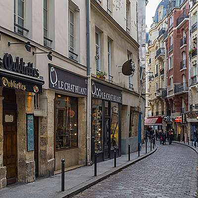
While my wife rested at the hotel, I headed out to scout the 6th arrondissement. Weaving through the narrow lanes behind our hotel, I soon reached Boulevard Saint-Germain. This stretch runs parallel to the Seine and serves as the main artery of the Left Bank; the commercial atmosphere here is noticeably more intense than in the Latin Quarter. I happened upon a Starbucks, I’d assumed a city so proud of its coffee culture wouldn’t have much of a market for it, but it turns out there are quite a few shops.


Continuing on to the Luxembourg Gardens, my first sight of the Medici Fountain, dappled in the shadows of the midday trees, was truly striking. Such beauty felt wrong to enjoy alone, so I hurried back to the hotel to bring my wife along.
We first grabbed lunch at Khao Thai near the hotel. Like most spots on the Left Bank, the tables were packed so tightly you could barely squeeze past. Their duck with tamarind was excellent. A quick tip: if you want plain water in Paris, remember to ask for “tap water.” Simply saying “water” will almost certainly result in a bottle appearing on your bill.

The number of small shops tucked into the alleys flanking Boulevard Saint-Germain is seemingly endless, especially around the Marché St-Germain between the boulevard and the park. The pastry shops are particularly dazzling; high-end patisseries are spacious and bright, decorated more like jewelry boutiques. Famous names like Un Dimanche à Paris and Pierre Hermé always have queues out the door. After visiting a few, I realized that macarons aren’t exclusive to Ladurée, every shop sells its own version.


The Luxembourg Gardens were commissioned in 1615 by Marie de’ Medici, widow of King Henry IV. The Medici name carried immense weight in Renaissance Europe. Rising from the banking sector in Florence, the family’s influence permeated European royalty, religion, and politics. Beyond their wealth and power, they were renowned patrons of the arts, often called the godfathers of the Renaissance. I remember a sign we saw in Florence that read, “It is a pity many contemporary collectors lack the taste of the Medici family.” Queen Marie’s own life was a whirlwind of court intrigue, regency, and eventual exile by her own son; many even link her to the assassination of Henry IV.
Entering from the northeast, the first thing you encounter is the Medici Fountain. A long, narrow pond leads to the sculpture at the far end. Surrounded by greenery, with ducks and fish gliding through the water, the setting is incredibly serene. The fountain underwent major reconstruction in the 19th century, which is when the current statues were added. While the dappled light is beautiful to the eye, the harsh midday sun makes photography a challenge.

Despite the lush greenery and flowers, the Luxembourg Gardens isn’t designed to be secluded; instead, it features wide vistas and orderly rows of trees, giving it a grand, open feel, said to be modeled after the Pitti Palace in Florence. The Luxembourg Palace now serves as the seat of the French Senate. The green iron chairs around the large circular pond were nearly all occupied, mostly by locals. Many parents were helping their children launch model sailboats into the water. For a Friday afternoon, Parisians seemed remarkably leisurely—I later learned about the 35-hour work week; perhaps the weekend truly begins on Friday afternoon here.

The western side of the park features wooded areas and children’s playgrounds, offering everything from pony rides to rollerblading. Nearly a hundred sculptures are scattered throughout the grounds.


Near the northwest gate and the Musée du Luxembourg sits Angelina, a famous Parisian tea house. While the original is next to the Tuileries Garden, this branch is much smaller. Angelina is renowned for its hot chocolate and the noodle-like Mont Blanc. Wary of too much sweetness, we shared one Mont Blanc and a coffee.

Walking back along Rue Bonaparte, we soon arrived at the Église Saint-Sulpice. Construction began in the mid-17th century and spanned 130 years. Ultimately left unfinished due to funding issues, its north and south towers remain asymmetrical to this day. It is the second-largest church in Paris after Notre-Dame, though its western facade is far more austere. Many key plots from The Da Vinci Code unfold within these walls.


Heading further north, we returned to the vibrant heart of the Left Bank: Saint-Germain-des-Prés. The area is most famous for its two legendary cafés, Les Deux Magots and Café de Flore. These spots were icons of early 20th-century literary and artistic history—you can practically point to a chair where Picasso sat or a table where Sartre dined. Of course, that was a century ago; today, they feel more like landmarks for tourists to capture a slice of that past life.
Across the street from Café de Flore is the Abbey of Saint-Germain-des-Prés, one of the oldest churches in Paris and the namesake of the district; Descartes is buried here.


Back at the hotel, we had some time before dinner, so I went out to catch the city lights. The tourist sights in Paris are all pretty close; the walk from our hotel to the Louvre took barely fifteen minutes.


In the plaza before the Louvre stands the Arc de Triomphe du Carrousel. From here, you can see the Obelisk at Place de la Concorde and the Arc de Triomphe at the far end of the Champs-Élysées. I waited quite a while for a clear shot without people in the frame. A cyclist rode past me and called out, “What a city!” Yes, what a city!

2014.10.30OpenStack summit in Paris was held in early November, that’s why we went to Paris at this time of the year. We were worried about the weather because supposedly it’s the time that cold weather starts moving in and it sees more rain. However, it turned out to quite extraordinary – there were much less tourists in early November, leaves started turning yellow, and we were so lucky to have some abnormal warm days. The best of all, we didn’t miss the rain, but only once. Who said that Paris is most beautiful in the rain?
We planed 9 days in Paris, including the conference days. We thought it would be more than enough, but in end we didn’t have to time to go to places, such as Versailles or Monet’s Garden, let alone countless museums in the city.
The plane landed at Charles de Gaulle Airport at 9:30am. We called a taxi to go into the city. The road was crowded, it’s about 11 o’clock when we got to the hotel. We’d stay at Citadines Saint-Germain-des-Prés Paris for 3 nights. The hotel is located at the 6th arrondissement, right next to the Seine and across the street from the Pont Neuf. Within the walking distance to many attraction, the hotel is a perfect starting point to explore the Left Bank of Paris.
As usual, after we settled down, my wife stayed in the hotel to have some rest and I had a walk to know the neighborhood. Along the Seine and towards the direction of Notre Dame, after passing Fontaine Saint-Michel, I walked until I got to the Petit Pont. It’s 5th arrondissement here. On my left, it’s the Parvis Notre-Dame; on my right, it’s the center of Latin Quarter.
Turned right on Rue Saint-Jacques, there is a small street on the left hand side, named Rue Galande. It’s short and narrow, but some well preserved medieval houses and cellars can be found on this street. The street appears both in “Midnight in Paris” and “Before Sunset”.


On the left of the street, there is a small and humble church, Église Saint-Julien-le-Pauvre. In fact, it is one of the oldest churches in the city. It’s history can be traced to as early as the 13th century. It looks plain and even dilapidated, a stark contrast to Notre-Dame across the river.

The garden north to the church is called Square René-Viviani. It’s just an ordinary garden except there is a 400-year-old locust tree in the garden. It’s said that that’s oldest planted tree in Paris. People enjoyed their lunch sitting on the lawn. There is a quite strange-looking fountain, called Saint Julien fountain, in the center of the square. which is built in 1995. This is a good place to overlook Notre-Dame across the river.

Next to the garden is the famous Shakespeare & Company Bookstore. Located at the French cultural center, the bookstore’s focus is selling English-language literature. This is in fact not the old bookstore that Hemingway and Joyce spent a lot of time with. The current bookstore on the Left Bank was build in 1951, and inherited the original bookstore’s style and name. When I got there, Jimmy Page was there to meet his followers and signed his biography for them. At the end of moive “Midnight in Paris”, there are several shots of the bookstore.


Returned to the street directly facing the Petit Pont. This is a busy street with many visitors and locals. Rue Saint-Séverin is on the right side, but you won’t be able to find a hint of quietness and arty style in Rue Galande. There are a lot of souvenirs and restaurants. You are also taste Korean, Mediterranean or many other regions food here as well.


I came back to the hotel. My wife and I had a lunch in a Cafe by the river. It’s 3pm now. We first walked around following my earlier route. When we returned to Shakespeare & Company Bookstore, Jimmy Page and many book shoppers had left. We had a chance to enter the bookstore. It’s dark and crowded, stacks and books were all over the place. It’s said that you can dig out some books that cannot be found elsewhere.

Latin Quarter is an area between the 5th and the 6th arrondissements. Compared to the area around Place de la Concorde where we lived later, the later one is high-grade and luxury, but Latin Quarter is active and lively, bookstores, cafes and restaurants are everywhere. Locals are having coffee by the busy road, watching people coming by, totally ignore the dust and loudness on the street. The cost of living is lower because a lot of low to mid-end shops are packed here. With Paris’ oldest university, Sorbonne, and a number of other higher education institutes in the district, Latin Quarte has always been the place where students and intellectuals want to hang out. Even today, when many quirky bookshops have given way to the chain clothing stores, the name alone evokes images of romantic and unconventional old Paris.
Île de la Cité divides the Seine into two at this area. Passed the Pont Neuf, it’s Notre-Dame. At 4pm, visitors waiting for entering the cathedral were still winding through the entire square. We walked along the river to the back of Notre-Dame. Square Jean XXIII is a quiet and peaceful park. From here, one can see the spire of Notre-Dame and the flying buttresses in long and beautiful shapes. One of major scenes in “Midnight in Paris” was shot here.


Pont de l’Archevêché at the east of Notre-Dame is the narrowest bridge on the Seine. Every bridge on the Seine has love locks, but Pont de l’Archevêché and Pont des Arts are two bridges that have enormous amount of them. So many love locks with so much weight are put on the bridge so that it creates a danger to crumble the bridge. Paris government had to remove them all together to save the bridge, but soon they came back again.


It passed 5pm when we returned to the hotel. One good thing in practical sense about our hotel is that free hot water is provided at the lobby. You cannot always drink coffee by the road. It’s still the golden hour even in the city. I grabbed my cameras and tripod and headed out again.
The dome of Institut de France is not the grandest compared to other great domes in Paris, but I found that some best pictures of mine were taken here. The following photo is selected because it has all the elements, the sunset, the Eiffel Tower, Institut de France, Pont des Arts and the western end of Île de la Cité.


Pont Neuf in fact is not “new”. On the contrary, it’s the oldest bridge on the Seine. The bridge has to sections that connect the Left Bank, Île de la Cité and the Right Bank. The body of the bridge was lighten up during the night and reflected in the river – a beautiful scene for photography.

After dark fell, I took some random shots in the streets of Île de la Cité.


We had our lunch at Chez Fernand, 5 minutes walk from our hotel. It serves French cuisine. Tasted good.


2014.4.5I got up in the dark and went to Alto Vista Chapel again. Crosses are erected along the road leading to the chapel. This time, a group of prayers gathered by the road and walking slowing towards the chapel.
It’s about 5:30am. The sky was cloudy, it’s not possible to see the sun rising on the horizon. The eastern side of Aruba is constantly attacked by trade winds from the Atlantic, waves moved in and hit the shore fiercely. Before the sun rises up, it’s quite foggy by the coast.

I returned to the Alto Vista Chapel. Prayers were sitting on pews, listening to the priest. Isn’t this spiritual?

Our plan of the day was to explore island’s inland and eastern region. The inland of Aruba is almost featureless. The highest hill is only 617 ft (188 m). However, there are several unusual sites of rock formations scattered at the heart of the island. They are unique in that, the rocks, unlike those with volcanic or coral origins allover the island, are monolithic tonalite boulders, rising above the desert soil.
We first stopped at Casibari Rock Formations. Steps were built to allow visitors to climb to the top of the boulder, which provide a panoramic view of the island.


A little to its east, it’s Ayo Rock Formations. The area is bigger than Casibari, with more strange-shaped rocks.


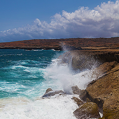
We kept on driving to one of Aruba’s most popular attractions, Natural Bridge. The last part of the road is unpaved, but it’s very easy to drive. The bridge was a formation of coral limestone, spanned more than 100 feet. It actually collapsed 10 years ago, but the view is still impeccable. Facing the open sea at Aruba’s very north shore, with lashing waves crashed over stark rocks violently, against the backdrop of dreamy sky in deep blue color. There were some good photo opportunities.

There is a bar on site overlook the collapsed bridge. A group of tourists came and the guide asked them to line up on top of the bridge. They were singing and dancing and really making a lot of fun of it.


1.5 miles northwest to the Natural Bridge, it’s Bushiribana Ruins, an abandoned gold mill that was once used to process ore from mines in the nearby hills. It’s built in 1825, less two hundred years ago, but probably because of the stark contrast to its surroundings, the ruins invokes feelings of much older history.


Near Bushiribana Ruins on the beach, there is a site where people stacked rocks up, and over time became the Wish Rock Garden. The similar scenes can be found in many places at Aruba’s northeastern coast.

We had the late lunch at La Trattoria el Faro Blanco by the California Lighthouse, then retired to our hotel. At the evening, we had the farewell party on the beach again. My wife’s company was quite generous to reward top performers, but someone has to write a big check for it.

We left Aruba in the second day morning. Most tourists in Aruba are Americans, so Aruba has an agreement with the United States government to have US Customs at the airport. This time, we had the connection flight at JFK airport, and we returned to our home in the afternoon.

2014.4.4In the morning, I got up at 6:30 and went to Alto Vista Chapel to shot sunrise. Someone said watching sunrise at Alto Vista Chapel is a spiritual experience, but it took me much longer time to get there than I though. The sun already rose up.
I drove about a mile north off road. Aruba’s northeastern beach is rocky. I didn’t want to get the tires damaged so I stopped and took some pictures of the rocky landscape. On the surface of the beach, there are a lot of igneous rocks, broken and rugged. The other type looked like coral reef, mostly beneath the surface. They seemed to be composed by narrow and parallel pipes in rock formation.


Returned to the hotel, after having the breakfast, we set off to see some landmarks of the island. Driving to the north, the road runs along the coast. Beaches become quite narrow and sand are coarse. There are no grand hotel anymore. Between Hadicurari Beach and Malmok Beach, not far from the coastline, there is a small shipwreck. A more famous shipwreck is Antilla Shipwreck, located between Malmok Beach and Boca Catalina Beach, further in the sea and cannot be seen from the coast. It’s a popular place for scuba diving.

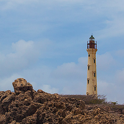
At the very north tip of the island, it’s California Lighthouse. It’s named after another ship wrecked nearby. Adjacent to the lighthouse is an Italian restaurant called La Trattoria el Faro Blanco. Both the lighthouse and the restaurant sit on a hill. The balcony of the restaurant offers a beautiful view of the western beaches and coastline and golf course Tierra del Sol.


We then visited Alto Vista Chapel, the place I just went to in the morning. The chapel itself itself was undergoing some construction. The surrounding area is semi-arid, almost fully covered by tree-like cactus.


The closest town to Alto Vista Chapel is called Noord, which has only a couple streets. We drove through the town back to the Palm Beach. We saw several Chinese restaurants by the road, but mostly empty. There were even a Chinese supermarket but also seemed closed. It’s said most of grocery stores and supermarkets are actually owned by Chinese in the island.

Near Palm Beach, along J.E. Irausquin Blvd. are the shopping area. We enter a store at Paseo Herencia Mall selling Mopa Mopa Artworks. These are woodcraft, masks, animal figures, boxes, with vivid colors. However, the colors are not painted on. The procedure to make these pieces are quite unique. The buds of the mopa mopa tree are boiled until they become a resin, like a gum. After adding vegetable dyes for the color, the artisans stretch the resin with hands and mouth, yes mouth, to make it into a thin sheet; then, it’s cut and applied to the wood. The tradition comes from Columbia. We bought a small fish from the store.

We went to a beach bar recommended by several locals to have the late lunch. To get to the beach, we have to cross Holiday Inn hotel. I have to say, Holiday Inn as well as Marriott are much more vibrant than Ritz-Carlton.

At the corner of Bubali road crossing island’s main road, L.G. Smith Blvd, there is a supermarket called Super Food Plaze. This is a huge place. It’s the Safeway of Aruba.

2014.4.2~3Less than two weeks after we came back from Polynesia, we were on our way to Aruba again. It was to attend my wife’s company event. We flew a red eye to get to Atlanta in the early morning, then from there, it took only 4 hours to reach this Southern Caribbean island.
This our first time flying over the Caribbean. The color of the sea was mesmerizing.


The bus took us to Ritz-Carlton Hotel, one of the newest and best hotels in Aruba. The organizer explained to us the schedule and all activities and dinner options. We checked into our room at 3pm. There were no activities on the arriving day. We waited in the room for the dinner party.

Aruba is located at the southern rim of Caribbean Sea. Only 18 mile orth of the coast of Venezuela, it is out of the hurricane zone across most of Caribbean region. Days in Aruba are always dry, warm and clear throughout all seasons. It’s sometimes windy because of trade winds from the Atlantic, but the Southwestern coastlines are mostly sheltered by the island. The party started at 6:30pm. There was nice view of the sunset from the Palm Beach.

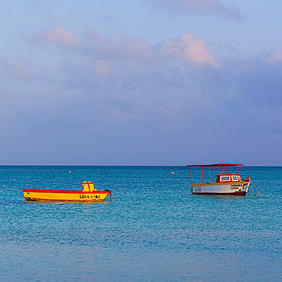
In the morning, I had a walk along the beach. Ritz-Carlton Hotel is located at the north end of Palm Beach, the 4-mile-long beach and high-rise hotel district of the island. There were several boat floating on the shallow water, some good object for photography, but the wave and direction of the light were not perfect.

I spotted a small stingray swimming at the shallow water.
Returning to the hotel, our room had a view of the northern side of the beach. Sea water near the coast are in different shades of blue. There are many water sport related small shops along the beach.


At the time when my wife had the company meeting in the morning, I went to the Hertz office at the first floor to rent a car. The agent tried to persuade me to rent a SUV. According to her, normal cars are not allowed to enter the Arikok National Park and some off-road places. My research before the trip told me that Aruba’s landscape is not that exciting, so I still decided to rent a normal car.
It’s free time after the lunch. We drove to the down, Oranjestad, the capital of Aruba, to do some shopping. Oranjestad is a busy town, tourists are everywhere and traffic is jammed. Aruba’s port is also right next to the town.


After shopping, we thought that we should go to see that other end of the island. We kept on driving to the south. On our way near the south end, we passed a town called San Nicolas, There were some deserted industrial facilities around the town. San Nicolas use to be a bustling town but now is running down.
The very south end of the island is semi-arid, covered by low bushes and dotted with tall cactus. The winding road led to a nice lagoon called Baby Beach. The water is calm and it’s good place for snorkeling.
