The Last Place on Earth – Planning
To most people visiting Antarctica, the journey is not only a once in a life time experience, but also an expensive one. The cost of the tour, cloths and cameras to bring and the time spent on planning are all much higher than normal travel trips. Here are some tips that are useful in our planning.
Time to visit
Ships and airplanes bring about 30,000 people to Antarctica every year. Most tour groups only operate between mid-November and mid-February, the summer of the southern hemisphere. The advantage of going earlier, for example, at the end of November, is that the price is cheaper and most lands are still covered by fresh snow. However, it’s going to be cold and storms are more common compared to later in the season. In later summer after January, the temperature drops again, but the area further south is more accessible because ice has been melting for the whole summer.

To us, as first time visitors, the best time to visit Antarctica is from late December through January. When we were there, the temperatures rarely dropped below the freezing point and we didn’t encounter any storm. More wildlife can be observed, especially, this is the time to see penguin chicks. Of course, it is the most popular season. The price is higher and the vessels are normally fully booked several months in advance.
Choose the Ship
Cruising in Antarctica is not your typical Caribbean vacation. Choosing the vessel that is designed to sail in the icy water over large and luxury cruise ships is recommended. Small ships offer much better opportunities of shore landings, which is the heart of Antarctica expedition. Many channels and bays are simply inaccessible for large ships. Carrying large number of passengers also means each one has less time on the shore. I heard some large ships only take visitors to see the continent; others can only bring their passengers to land in a batched manner. The downside of smaller ships is that you will feel the wave harder in the tough sea.

Here are the tour companies we considered before we booked the trip,
Most these companies’ ships are refurbished from the boats that were originally used for research and explorations in the polar regions. The ship we traveled on was M/V Antarctic Dream. It has a capacity of 80 passengers and 40 crews. It served in Chilean navy under the name “Piloto Pardo”, which was to remember the captain that rescued Ernest Shackleton‘s crew after their failed expedition to be the first to cross Antarctica continent in 1916.
Itinerary
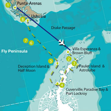
The duration of Antarctica cruise varies from 4 days to 20 days. Typical programs focus on the Antarctic peninsular, where the best combination of wildlife and landscape are presented. Ships normally spend 4 to 5 days in the region and do two landings each day depending on weather conditions. Itineraries and landing sites offered by these programs are very similar, but small differences do exist. For example, our program gets into Weddell Sea through the Antarctic Sound, which most tours don’t go. If you want to see more kinds of penguins, such as King penguin and Macaroni penguin, you should look for programs that can take you to Falkland and South Georgia islands. Some programs sail further south into the Antarctic Circle if weather agrees. It probably won’t offer anything distinguish besides the feeling of achievement.
Another thing you should consider is how to get to and leave Antarctica. “Classic” peninsular cruise spends two days each way on Drake Passage. If you are sensitive to the wave or have a tight schedule, recently, companies started offering fly-in/fly-out options. The airplane takes only two hours to cross Drake Passage. However, I think an Antarctic experience without Drake is incomplete. It’s one of the reasons that we chose Antarctic Dream because it has the programs to fly on one leg and sail the other. More specifically, I prefer sail-in/fly-out option, (but we had to choose the other direction to fit into our schedules), because you will have two days to get familiar with the ship and the weather, learn more about the continent through lectures and build up your expectation. Antarctica will live up to it!

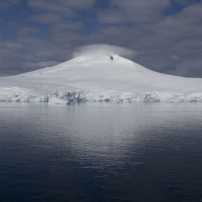
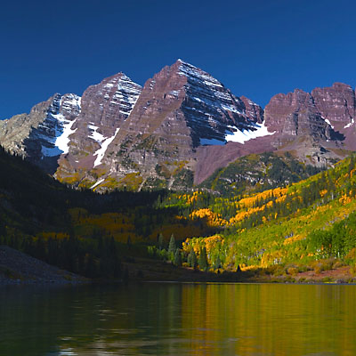
Overall, we are very satisfied with our itinerary. Eight landings were planned, six were taken. In every landing, we stayed ashore for one hour to two and half hours. We saw penguins, seals, whales and many sea birds. We sailed through the most beautiful channels, such as Lemaire Channel and Antarctic Sound. They were really breathtaking.
Price
The price of Antarctica cruise varies greatly for different programs, seasons and the vessels and cabins you choose. The base price for the “classic” programs, 10-day peninsular cruise starting and ending in Ushuaia, is around $5000 as of now (2012). With the fly option, no matter for one leg or both legs, the price is almost doubled. For the cabins of lower price, you should check if the cabin has private facilities and windows. Normally, no extra is charged if you want to share the cabin with other individuals.
One thing different from booking a flight is that, you pay the premium to reserve the room in advance, but the best price appears at the very last days before the ship leaves, if cabins are still available. In Ushuaia, I saw some last-minute deals at $3600. If you are a backpacker travelling around Patagonia, this can save you a lot of money. Our ship cut the base-rate cabin’s price in half three weeks before the travelling day. In case you have already made the reservation, you could negotiate with the company for an upgrade or adding more persons without extra charge.