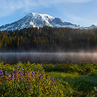
Mt. Rainier – Paradise

2013.8.35am at morning, I didn’t gave up the hope that the sky might be cleared. Looking out through the window, I could see surrounding mountains clearly. Magic! I grabbed my gears and run out of the hotel, together with several fellow photographers.

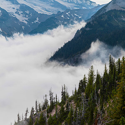
When we got to the reflection lake, thick fog still dominated the lake. Another two photographers told me, they came last year and it was a day like this. Although the paradise area was clear, the sun hadn’t shown up until too late around the reflection lake. Pondered for a while, we decided to go some other places. 2 miles back toward the paradise area on the left-hand side, there is a vista point that is facing the mountain and overlooks the valley. No cloud, the light was warm.

Mt. Rainier Sunrise
Sunrise in Mt. Rainier

The reflection lake must be good now. We all drove back. Less than 10 minutes after we left, the sun has dispersed the cloud, only light fog remained above the surface of the lake. A short trail led me to the lake shore. It was perfect, I couldn’t ask for better conditions. I spent about half an hour around at the lake side.

Sunrise over Reflection Lakes, Mt. Rainier

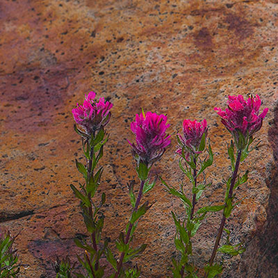
I went back to the lodge to meet my wife and we decided to do some hiking in this beautiful morning. Nisqually Vista Trail is at the west side of paradise area. The trail is a loop and easy to walk, unfortunately it’s not as exciting as the Skyline Trail. The glacier retreats fast, there was not much too see indeed; and the flowers were not abundant.

Nisqually Vista Trail, Paradise, Mt. Rainier
Panorama view from Nisquallly parking lot, Mt. Rainier
Panorama view from Nisquallly parking lot. Clouds were still in the valley. Mt. Rainier

We decided to have a walk again between the lodge and the Myrtle Falls, the same section of Skyline Trail we hiked the previous day. It’s around 8am. The view was fascinating, but as the sun rose higher, the light quickly became too harsh for photographing.

Skyline Trail, Paradise, Mt. Rainier
Myrtle Falls, Skyline Trail, Paradise, Mt. Rainier
Myrtle Falls, a signature view of the nation park. The light was too strong already. Skyline Trail, Paradise, Mt. Rainier

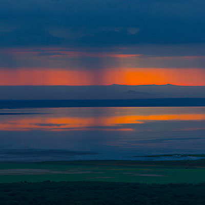
We returned the lodge in time to catch up their serving of breakfast. We checked out the lodge at 9am. Our destination was Portland, Oregon, so we would leaving from the Nisqually Entrance. Not far from paradise area, we stopped by at Nevada Falls, and walked down to the view point. It’s a popular site and maybe the first attraction for tourists coming from this direction. On our way leaving the park, I noticed the clouds started returning to the park. We were really lucky to have a chance to see Mt. Rainier’s different faces. The final highlight was short but priceless.

Navada Falls, Mt. Rainier
2评论

Mt. Rainier – A Walk in the Clouds

2013.8.2I got up at 5am. My plan was to drive to the Tipsoo Lake to take pictures of Mt. Rainier’s reflection at sunrise. I sticked to my plan although there was no sign that the clouds would go away. Certainly, they didn’t and they were thicker than the previous day. I still drove to WA-410 and WA-123 fork, very close to the Tipsoo Lake. I really couldn’t see anything. I had to give up. At Lower elevation, it’s just a cloudy day. I returned to Ohanapecosh campground and took some pictures of the river under the bridge.

Ohanapecosh River, Mt. Rainier

We checked out of our lodge at 9:30. We drove to the Paradise area through Stevens Canyon Rd. About half way between WA-123 fork and Paradise, there is stone bridge right in front of a tunnel. We made a stop there. The area is called Box Canyon. Under the bridge, the gorge is like a narrow and deep slice, the raging water is far below the bridge. The Box Canyon Loop a short hike that take no more than 15 minutes. The air was so humid (we were in the cloud) that it seemed one can squeeze water out of it. The fog gave the view a touch of desolation.

Box Canyon, Mt. Rainier
Box Canyon Loop, Mt. Rainier

It’s still too early to get a room when we reached Paradise Inn. We knew the lodge has almost 100 years of history, but what we saw still impressed us very much. The lobby (The Great Hall) is huge and inviting. There are two fireplace and a lot of chairs for guests to enjoy this wonderful construction. We had a lunch at the restaurants and set off to explore the hiking trails of Paradise area. We walked Skyline Trail toward Myrtle Falls. Crossed the bridge, we kept on Golden Gate Trail for another half a mile.

Pink Mountain Heather, Skyline Trail, Paradise, Mt. Rainier
The creek near Myrtle Falls, Skyline Trail, Paradise, Mt. Rainier
The creek above Myrtle Falls, Skyline Trail, Paradise, Mt. Rainier
Paradise Inn front door in a gloomy day, Mt. Rainier
Paradise Inn front door in a foggy day, Mt. Rainier

We returned to Paradise Inn and checked into our room. My wife decided to stay in the room and I’d have a hike by myself. I took the opposite direction of Skyline Trail, detoured on Alta Vista Trail and turned back through Deadhorse Creek Trail. It’s a nice day for hiking but difficult for photography. Dewdrops hung on every petal, but I could hardly take pictures on any flower 20 feet away.

Magenta Paintbrush, Skyline Trail, Paradise, Mt. Rainier
Skyline Trail, Paradise, Mt. Rainier
Avalanche Lily, Deadhorse Creek Trail, Paradise, Mt. Rainier

I walked for one and a half hour and retired to our hotel. Nothing beat the feeling of sitting in the cozy and warm lodge, watching the gloomy weather outside and having a cold beer after a long walk.

Paradise Inn, Mt. Rainier
The great hall of Paradise Inn, Mt. Rainier
Paradise Inn, Mt. Rainier
Upstairs of Paradise Inn, Mt. Rainier
0评论

Mt. Rainier – Sunrise

2013.8.1I still clearly remember the view when last time we drove from Seattle city to Sea-Tac Airport 8 years ago – a huge mountain, standing by itself, dominated the horizon, bold and respectful. That’s Mt. Rainier, whose prominence (4,027 m) ranks #21 in the world. Mt. Rainier is also renowned for blooming wildflowers during the summer months. This year, we finally got a chance to visit Mt. Rainier in the peak blooming season at the end of July.

Our flight arrived at Seattle at 9am. We took WA-410 to go to the park. It’s as cloudy as Seattle’s sky normally is, but after 2 hours, when we entered the park, it’s getting clear. At one point as we passed Sunrise Park Rd. fork, we could see Mt. Rainier.

White River, Mt. Rainier

We turned right at WA-410 and WA-123 fork to Tipsoo Lake before going to the lodge. We stopped at one vista point to overlook the valley. Clouds were moving fast up against the valley toward us. We were not aware that the clouds would stay in the park for the rest of two days.

Tipsoo Lake is a lovely lake with tranquil water. The whole area was covered by wildflowers. A lot of Lupine, dotted with Pasque Flower seed head in white and Arnica in yellow. A hiking trail surrounds the lake. From the far side of the lake, one can photograph Mt. Rainier’s reflections, but as I was taking pictures on this side, clouds started moving into the lake and soon swallowed everything within. I didn’t have a chance to see the reflection, but the cloud also made this flower-surrounded small lake like a fairy place.

Lupine and Pasqueflower Seedhaed, Tipsoo Lake, Mt. Rainier
Tipsoo Lake, Mt. Rainier
Clouds approaching the Tipsoo Lake, Mt. Rainier
Lupine and Cow Parsnip, Tipsoo Lake, Mt. Rainier
As we reached the other side, the lake had been immersed in the cloud. Lupine and Cow Parsnip, Tipsoo Lake, Mt. Rainier
Tipsoo Lake, Mt. Rainier

As we left the Tipsoo lake, we couldn’t even see the road at some section because the cloud was too thick. We literally walking in the cloud, until we reached lower elevation, the cloud really became the cloud. We booked the lodge of our first-day stay at Parkwood area. Along Hwy. 12, Parkwood is not even a town. It only has a couple of stores, restaurants, and hotels, but the lodge we booked, Timberline Village, is 4 miles outside the area towards the park. We totally missed it at first. A local man asked us to follow his car and helped us find the lodge.

Although the facility is basic, the room is spacious with a very good shower. We had lunch at Cruiser’s Pizza because of the coupon that the lodge left on our room table. It’s maybe the only normal dining place in the area. The food is fresh. My wife said the burger was the best she had in years.

Parkwood area, Washington
Street of Parkwood, Washington

We returned to the park after some rest. The whole park was still in the cloud. We wanted to try our luck at Sunrise area.

Ohanapecosh Entrance, Mt. Rainier
Hexagonal lava columns, Sunrise Park Road, Mt. Rainier

Two miles from Sunrise Visitor Center at Sunrise Lake Point, the cloud was so thick and we could barely see anything 30 feet away. We had little hope to see the mountain at all. There were only a handful cars in Sunrise Visitor Center parking lot. The rangers were about to leave and the only thing they could tell us about the weather was that it’s unpredictable. As we were walking toward Frozen Lake, I felt the cloud lifted up a little bit. We decided to change the route to go to Emmons Vista. Gradually, the sun dispersed the clouds and the majestic Mt. Rainier revealed itself in front of us. For 20 minutes, we were walking above clouds.

Sunrise, Mt. Rainier
Emmons Glacier in clouds, Sunrise, Mt. Rainier
Sunrise, Mt. Rainier
Mt. Rainier in clouds, Sunrise, Mt. Rainier
Sunrise, Mt. Rainier
Sunrise Lake, Mt. Rainier

Clouds soon reclaimed the Sunrise area. We were hoping the next day would be a better day.

0评论

坦桑尼亚 – 埃亚湖

2012.12.27早晨10点,我们离开Kirurumu Manyara Lodge,沿着B144号公路继续向南。大约半个小时后,我们进入另一个小镇。这里是卡拉图区,是阿鲁沙大区六个地区中的一个。Justin的家就在这个小镇附近。我们在一个店铺门口停了一下,Justin给家里留了些东西。

Karatu District
小镇卡拉图

又开了5公里,我们向左拐上一条土路,开往埃亚湖。

T K Eyasi Rd.
开往埃亚湖的T K Eyasi路,在卡拉图区的Oldeani附近。
Southern Ground Hornbill, T K Eyasi Rd.
T K Eyasi路边的两只红脸地犀鸟(Southern Ground Hornbills)。

这条土路有些颠簸。随着位置越来越向南,天气也变得越来越热。这里没有高大的植被,路边只有星星两两的灌木。

Barren land near Lake Eyasi
接近埃亚湖附近贫瘠的土地
Massai Cottage near Lake Eyasi
埃亚湖附近马赛人的茅草房

大约过了一个小时,我们在路边看到一个小亭子,这是埃亚湖区的入口和收费站。这里只有一个人值班,来访的游客显然不多。我们等了一会儿,来了一个本地人和我们一起上了车。他将带领我们参观Hadzabe和Datoga原始部落。

Reception office of visiting tribes in Lake Eyasi area
埃亚湖游览区的入口

继续向前开了大约5分钟,我们在向导的指引下离开主路,开入灌木丛。哈扎比(Hadzabe)部落是非洲唯一的仍然以狩猎采集为生的部落,人口总数不超过1000人,全部居住在埃亚湖周围。在过去的几十年中,当地政府几次想对这些部落进行管理或是引导他们与其他文化融合,但是都没有成功。现在的做法是,对于重要的政治事件,政府会与部落交流;在其他的情况下,遵循哈扎比部落的传统,让他们以千年来一贯的生活方式生活。实际上,旅游业的发展、游客的到来对部落传统的冲击更大,但毕竟这已是不可逆转,至少哈扎比的小孩现在有了更多的受教育的机会。

Hadzabe Bushmen Tribe, near Lake Eyasi
哈扎比部落的妇女,埃亚湖
Hadzabe Bushmen Tribe, near Lake Eyasi
在吸烟的哈扎比人,埃亚湖
Hadzabe Bushmen Tribe, near Lake Eyasi
哈扎比部落的小孩儿,埃亚湖
Hadzabe Bushmen Tribe, near Lake Eyasi
哈扎比部落的小孩儿,埃亚湖

我们在的时候正是中午,部落的族人大多坐在阴凉里。有的人在用土烟斗抽烟,有的人在加工打猎的工具。几个年轻人给我们演示了钻木取火和射箭的技能,也让我们尝试了一下。射箭的弓很硬,我射得还不错;但无论如何也点不着火。向导带领我们在部落里走了一圈,给我们指示了部落的人用来避雨的巨石。在部落的入口处有一棵大树。树干上挂满了猎物的头盖骨。在我们离开前,年轻人和小孩儿围成一圈,载歌载舞。这大概是他们一种庆祝的仪式。有兴趣的话,游客可以参加族人早晨的狩猎。部落的猎物以鸟类居多,偶尔能够打到狒狒(Baboons)这样大型的动物。

Hadzabe Bushmen Tribe, near Lake Eyasi
制作弓箭,哈扎比部落,埃亚湖
Hadzabe Bushmen Tribe, near Lake Eyasi
射手,哈扎比部落,埃亚湖

离开哈扎比部落的灌木林,我们下一个项目是拜访Datoga部落的家庭。这一家的院子离主路很近,所以我不知道他们是真正的原居部落,还是为了游客而仿设的。Datoga是一个一夫多妻的部落,家里所有的妻子都出来迎接我们。妻子中最小的一个看起来还是个孩子,显然对我们的来访并不是太习惯。Datoga部落的房子都很低矮。我们猫着腰走进了一间茅草房,这是家里加工储藏谷物的地方。我们观看了妻子们跪在地上研磨玉米的过程。在院落的另一侧,是家中融化金属,打制弓箭的地方。Datoga部落给哈扎比部落提供武器,用以换取哈扎比部落的猎物。他们也打制手镯,卖给来访的游客。导游告诉我们,Datoga部落使用的金属原料来自周围的村庄,我们也看到他们用来制作手镯的铜管。铜管已经是近代工业的产品,而部落的人把它们重新打造成箭弩,与原始部落的人交换,这让我有一种穿越时空的感觉。

A family of Datoga Tribe, near Lake Eyasi
一个Datoga部落家庭妻子们的合影,埃亚湖

我们在埃亚湖湖畔驻扎的帐篷旅馆是Tindiga Tented Camp。旅馆的前台就是饭厅。和前面两个相比,这家帐篷旅馆可简陋的多了,大概是因为来的人少。我们两点钟到达,到我们第二天出发也只有我们一家,不过旅馆的老板说前一天有大概二十多人住在这儿。

我们休息了一会儿,觉得还是让Justin带我们去周围转转。吉普车爬上附近的山丘。向东望,村边有很多的农田;向西,大约一两公里外就是埃亚湖。Justin说因为是雨季,那边的道路一定很泥泞,估计开不到湖边,那跑过去的意义就不大了。

Agriculture area near Lake Eyasi
埃亚湖附近的农田
Overlook Lake Eyasi
远望埃亚湖
Kids from the village followed us to the hill top, near Lake Eyasi
村里的小孩儿跟着我们的吉普车上到山顶。他们完全没有拘束的样子。

Justin希望我们能看看普通坦桑尼亚人的生活,他把车开到山脚下叫Qaund’ded的村庄。村边的有一个小池塘,村里人用的水都要到这里来取。我们看到很多小孩儿拿着塑料桶到池塘里打水抬回家。大多数人对我给他们拍照并不介意,但是有一个女孩儿表示明显的不满,我只好把相机收了起来。

Villagers carrying water from a pond by the village, near Lake Eyasi
埃亚湖边村庄里的小孩到池塘打水。
The water source of villages near Lake Eyasi
池塘里的水是这个村庄的唯一水源。
The girl was not happy about us taking pictures on them.
镜头里的女孩儿非常反感我给他们拍照。

我们开车从村中穿过。Justin说这一片地区适合农作物生长,当地人劳作也很辛苦。不过从村子的房子来看,村民的生活应该是非常贫穷的。

A village near Lake Eyasi
埃亚湖边的Qaund’ded村
A village near Lake Eyasi
埃亚湖边的Qaund’ded村

回到帐篷旅馆,我们和Justin一起在前厅吃晚饭。说道中国和坦桑尼亚上个世纪的友好关系,旅馆的老板拿出手电筒、打火机等东西,告诉我们这都是中国货。我心里觉得这好像并不能说明两个国家早年间的那种“兄弟友谊”。不过确实因为那时的历史,坦桑尼亚人对中国还是非常认可的。我们又谈到了当地婚姻的风俗,子女的教育。Justin在这点上很传统。他很看不惯西方文化对坦桑尼亚学校系统的影响,觉得现在的孩子都被宠坏了。如果有可能,他会让他的女儿去允许体罚的学校!

第二天早晨,我被帐篷外的鸟鸣声叫醒。我提着相机在旅馆里走了一圈。初升的太阳很暖,又没有很刺眼。想不到在这么干热的地方有如此色彩斑斓的小鸟。我拍了几张鸟的照片,还比较满意。

Strange plant, Tindiga Tented Camp, near Lake Eyasi
Tindiga帐篷旅馆院子里奇特的植物
Tindiga Tented Camp, near Lake Eyasi
我们在Tindiga旅馆的帐篷
Love birds, Tindiga Tented Camp, Near Lake Eyasi
Love birds,Tindiga帐篷旅馆
Common Bulbul, Tindiga Tented Camp, Near Lake Eyasi
Common Bulbul,Tindiga帐篷旅馆
0评论

坦桑尼亚 – 东非大裂谷和马亚拉湖国家公园

2012.12.26我们离开塔兰吉雷国家公园的时间大约是早晨10点。在土路上开5公里回到主路,向阿鲁沙的方向开10公里左右,然后向左转上B144。这是一条贯穿坦桑尼亚北部的主要公路。这一段的公路笔直平坦。因为没有水源,道路两旁的地表很干旱,没有什么高大的树木,只有一些稀疏的矮灌木。塔兰吉雷到马亚拉湖的距离并不远。从这里我们已经可以远远看到马亚拉湖的南端。

From Tarangire to Lake Manyara
从塔兰吉雷到马亚拉湖

大约一个小时后,我们开入马亚拉湖国家公园的范围。公园的东南方有一个小城镇,Mto wa Mbu。Justin带我们走近附近的一个村庄。穿过一片香蕉园,是几间村居和茅草房。其中一间草屋用来展示木雕和手工艺制品。一些工人正在雕刻打磨新的制品 – 这是一间制作木雕的作坊。

Banana field near Mto wa Mbu
Mto wa Mbu的香蕉园。
Village near Mto wa Mbu
Mto wa Mbu附近的村庄。

坦桑尼亚的传统木雕技艺精湛、创意独特,是世界闻名的手工艺品。来坦桑尼亚旅游的游客都要买上一两件。作坊里的人先给我们做了一个简单的介绍。大意是,他们是来自莫桑比克的马孔德部落,而他们制作木雕的灵感来源于日常生活和梦境。与他所讲的故事相比,他讲故事的方式更让我们印象深刻。他的声音平缓但是很有自信,故事衔接紧密,完全是一篇有说服力的销售讲演。虽然这里地方不大,讲解的人看来却是身经百战。他告诉我们用来制作木雕是乌木(Ebony)。乌木的断面是白色的外层包裹着坚硬的黑色内里,是十分珍贵的木材。不过在阿鲁沙的时候Achmed就告诉我们,不管卖家做什么,用砂纸打也好,将木头沉在水里也好,市面上的木雕都不是真正的乌木。我们在这里买了一些香蕉叶制作的挂画。

Locals carving the wood near Mto wa Mbu
作坊里的工人在打磨木雕。

中午天气很热,连动物也不愿意出来活动。我们决定先去旅馆。从马亚拉湖国家公园大门口经过,公路陡然上行。 Graben and Half-Graben (from Wikipedia) 我们实际上正沿着著名的东非大裂谷的西壁攀升。与冲积风化而形成的河谷不同,裂谷在地球的板块运动中形成的。地壳的抬升和坳陷经常会产生平行的断层。这一段的东非大裂谷是半地堑。板块的一侧地势抬高600多米,形成裂谷的西壁;另一侧依然水平延伸。马亚拉湖就位于隆起断层的山脚下。

路边有几家纪念品商店。商店的门前挂着Tingatinga风格的绘画;商店里面是数以千计的木雕制品,从一两寸高的雕像,到实体大小的猴子、水牛,在货架上摆放得满满当当。Justin告诉我们,再向前走,买纪念品的机会就不多了。我们选了三件大约一尺左右高的人像雕塑,砍了40%的价格。即使按这个价格,这个商店的摆放的物品的价格也可以值到上百万元。一方面可见商品数量之多,另一方面应该是我们杀价杀得还不够。

Handcrafts and wood craving store near Lake Manyara.
东非大裂谷上摆满木雕的纪念品商店。

吃过午饭,我们进驻到Kirurumu Manyara Lodge。这也是一家“豪华帐篷旅馆”。下了公路到旅馆要开一段挺长的土路。旅馆位于东非大裂谷的悬崖边,位置得天独厚。从旅馆的入口,石子铺路的小径逐渐分叉,延伸到各自的帐篷门口。整座帐篷就象是一间小木屋,被树木包围着。从帐篷口的平台上,可以看到马亚拉湖。

Kirurumu Manyara Lodge
我们在Kirurumu Manyara Lodge的帐篷
Overlook Lake Manyara National Park
从帐篷口的平台上瞭望马亚拉湖。可以看到湖上的雷雨天气。

下午出发有点儿晚。4点钟,我们从裂谷的山坡下山。一进公园,燥热的天气似乎一下子被挡在门外,气温好像低了好几度。

Thunderstorm near Lake Manyara National Park
下山时看到Mto wa Mbu镇子的方向有一朵巨大的雨云。这一场雷雨看起来不小。

因为水源充足,与塔兰吉雷国家公园不同,马亚拉湖国家公园的大部分为茂密的森林所覆盖。游览的路线就是在丛林中穿行。离公园的入口不远的东北角,有一个小池塘叫做“河马水塘”。我们远远地只看到一只河马伏在池塘里。Justin告诉我们要看河马,塞伦盖蒂公园有很多。行车路线的两侧有成群的狒狒,有些在树林里游走,有些懒洋洋地躺在草地上。因为树木茂密,马亚拉湖国家公园也是观赏鸟类的好地方。

Game drive in Lake Manyara National Park
马亚拉湖国家公园的“game drive”
Blue Monkey, Lake Manyara National Park
马亚拉湖国家公园的青长尾猴
Sausage trees, Lake Manyara National Park
马亚拉湖国家公园的吊灯树
Silvery-cheeked Hornbill, Lake Manyara National Park
银颊噪犀鸟,马亚拉湖国家公园
Blue-ball monkey, Lake Manyara National Park
生殖器呈蓝色的绿长尾猴,马亚拉湖国家公园

马亚拉湖国家公园的游行路线是一个环形,与北面的森林地带不同,公园的南部更多的是因为湖水涨落冲积而成的草甸,更容易看到动物。

Lake Manyara National Park
马亚拉湖国家公园的斑马群,背后是东非大裂谷的断层。
Dik-dik, Lake Manyara National Park
犬羚,一种体型细小的羚羊。
Lake Manyara National Park
在低矮灌木中漫步的长颈鹿
Lowland in the south end of Lake Manyara National Park
马亚拉湖国家公园南端的低地

我们在公园里游览了大约两个多小时。在回旅馆的路上,我在大裂谷的崖边照了几张相。原来一直以为东非大裂谷是凹陷的低地,现在才看到它真正的模样。

Sunset over Lake Manyara
马亚拉湖的日落
Great Rift Valley
东非大裂谷
Serengeti Beer, dinner at Kirurumu Manyara Lodge
塞伦盖蒂啤酒,在Kirurumu帐篷旅馆的晚餐。

第二天早晨,我六点钟起床。在餐厅的一侧有一处面向马亚拉湖的平台。这里有一个吧台,向前眺望,是欣赏湖景的绝佳所在。与前一天在塔兰吉雷国家公园的日出相似,天边布满了乌云,却只在天边裂口一道窄窄的狭缝。如果塔兰吉雷国家公园的日出可以用壮丽来形容;马亚拉湖的日出却是若隐若现。加上湖上的水天相接的雷雨,又是一种朦胧神秘的色彩。

Sunrise and thunderstorm over Lake Manyara
马亚拉湖的日出和雷雨
Sunrise over Lake Manyara
从东非大裂谷遥望马亚拉湖的日出
Lake Manyara National Park Map
马亚拉湖国家公园的地图
0评论

Big Sur

2013.7.5I drove California Highway 1 many times in the past, but I never stopped at Big Sur. During our stay in Carmel, we had a half-day trip to Big Sur and stopped by several most famous landmarks.

Garrapata Beach, Big Sur, CA
Bixby Bridge, Big Sur, CA
Pfeiffer Beach Blow Hole, Big Sur, CA
Pfeiffer Beach blowhole, Big Sur, CA. The beach has a hint of purple color, but what makes the place famous is, only a couple of days in winter at sunset, the sun light can just reach the beach through the blowhole, which creates very dramatic images.
Julia Pfeiffer Burns State Park, Big Sur, CA
Julia Pfeiffer Burns State Park, Big Sur, CA.
McWay Falls, Big Sur, CA
A signature view of Big Sur – McWay Falls, Big Sur, CA
0评论

Carmel-by-the-Sea

2013.7.4~6Feeling nowhere to go, we spent two nights in Carmel during the Independence Day weekend. It’s certainly not as exotic as our other trips, but it’s also much easier and cozier. I only wish they could have more better restaurants. We stayed in Carriage House Inn. We love their afternoon wine and cheese tasting very much.

0评论

坦桑尼亚 – 塔兰吉雷国家公园

2012.12.25~26我们早晨八点离开阿鲁沙的旅馆,在市中心换了些现金,然后继续向西前往塔兰吉雷(Tarangire)国家公园

半个小时后,梅鲁火山已经成为远处的背景,呈现在我们眼前的是一片广阔的平原,零星点缀着马赛人的村庄。这些村庄大多只是几间低矮的茅草房包围的牛羊圈。我们和Justin慢慢熟络起来,话题渐渐谈到他的生活、他的家人。提起政府的腐败和社会上的不公平,Justin变得非常生气,声音也提高了很多。

A Maasai village by the lake
从阿鲁沙到塔兰吉雷的路上,马赛人的村庄。

自从阿鲁沙出发,天气一直阴沉着。车开了一个小时,开始下起雨来,很快就变成了瓢泼大雨。坦桑尼亚的北部有两个雨季。十一月到十二月间的雨季较短,降雨量有限。不过据Justin讲,今年的十一月干旱,到十二月下旬才开始下雨, 所以现在的雨水比往年这个时候要多。反正我们去到哪儿就把雨带到哪儿,倒也习以为常。雨下得很急很大,路边很快形成了很多的水塘和小溪。幸好这个时候的雨一般都很短,大多数的路段铺得也很好,我们没有遇到什么问题,十点半时到达公园的大门。

Maasai herders
马赛人的牛群

塔兰吉雷国家公园是除塞伦盖蒂以外最大的野生动物聚集地。这一区域的旱季非常炎热,塔兰吉雷河是唯一全年不断流的水源,所以各种野生动物都迁徙到河边。到了雨季,大多数动物都四散开来,成群的非洲象成为公园的主角。

Elephant, Tarangire National Park
一年两季在塔兰吉雷国家公园都可以看到数目众多的非洲象。
Abdim's Stork, Tarangire
塔兰吉雷国家公园入口附近看到的白腹鹳(Abdim’s stork)

鸵鸟对舞 – 在非洲看到鸵鸟让我们有些惊讶。实际上,鸵鸟原生于非洲。澳洲的鸵鸟都是人工饲养的。
Visitors in Tarangire National Park
塔兰吉雷国家公园的游客

我们的计划是上午在公园里做短途的游览,吃过午饭再去我们的野营地。离塔兰吉雷河越近,风景变得越来越漂亮。广阔的草原如波浪般起伏,一棵棵猴面包树(Baobab)和金合欢树(Acacia )鳞次栉比地点缀其中,而我们的吉普车就在这一望无际的草原中向深处一直开进去。这就是我想象中东非草原的模样,又仿佛是电影中的场景,我的心情激动得几乎要大叫出来。

Tarangire National Park Landscape
塔兰吉雷国家公园的风光
Game drive in Tarangire National Park
塔兰吉雷国家公园的Game drive
Flooded Tarangire River because of the early rain, Tarangire National Park
早晨的暴雨让塔兰吉雷河漫出河岸。

午餐的地点位于塔兰吉雷河边的高地上。在这里休息的游客来自很多不同的国家,中国的、印度的、阿拉伯地区的都有,有些只是从阿鲁沙过来一日游的。游客的活动也吸引了一群黑脸长尾猴(Black-faced Vervet Monkey)。它们象峨眉山的猴子一样,一点儿也不怕人。稍不注意,它们就跳上桌子,偷去游客的食物。

Black-faced Vervet Monkey, Tarangire National Park
塔兰吉雷河边休息点的黑脸长尾猴
Centipede, Tarangire National Park
好像是蜈蚣的多足爬虫

Tarangire Safari Lodge是在东非国家公园里经营的几十家“豪华帐篷旅馆”中的一个。除了把房间换成帐篷,这些露营地的条件和服务和一般城市里的旅店很相似。帐篷很宽敞,私人的浴室和厕所连接在帐篷后面。这些帐篷旅馆在品质上因位置和档次不同有很大差别,Tarangire Safari Lodge是我们住过的最好的一家。

旅馆位于塔兰吉雷河边的高地上。旅馆的前厅完全是开放式设计,大厅中间摆放着沙发。坐在大厅里,塔兰吉雷河谷壮观起伏的风貌毫无阻碍的呈现在眼前。所有的帐篷都建在河谷的崖边,不用离开帐篷,就可以看到大象、长颈鹿在河谷的丘陵上自在地徜徉,成群的斑羚在金合欢树间追逐嬉戏的景象。

Tarangire Safari Lodge
Tarangire Safari Lodge开放式的大厅。
Tarangire River
从Tarangire Safari Lodge俯瞰塔兰吉雷河谷。
Camps in Tarangire Safari Lodge
从外面看我们住的帐篷

中午的阳光炽热而强烈,动物也很少出来活动。我们在帐篷里休息到下午四点,才又出发。当我们穿过塔兰吉雷河的时候,早晨几乎漫出河床的河水只剩下一道溪流。

Tarangire National Park
塔兰吉雷河边的棕榈树
Termite mounds, Tarangire National Park
拱出地面的白蚁丘穴

如果有几辆车同时停在路边,那么你停下来看看也多半没错。不同的是,这一次一共有二十几辆吉普车一字排在路边,车上的游客都拿着望远镜眺望,而我们一眼望去,却什么也看不见。Justin问了其他的司机才知道,在远处的树下有两只非洲野犬。非洲野犬是濒危物种,据说在整个坦桑尼亚北部的国家公园里只有两群。如果你看过BBC的纪录片《Planet Earth》,它们在第一集里就出现过。非洲野犬的皮毛呈黄、黑相间的色块,仿佛是随意泼墨而成的作品,也许是适应灌木间斑驳的树影而形成的保护色。说不上美丑,但确实让人印象深刻。

African Hunting Dog, Tarangire National Park
一对伏在树下的非洲野犬

继续向前,一群大象在一个小池塘边饮水戏耍。有的时候,小象在池塘里呆得太久,几乎无力上岸,还需要成年象助一“鼻”之力。

塔兰吉雷国家公园面积广阔,早晚温差也很大,造成不同的时间地点天气变化多样。我们经常看到远处的天空乌云聚集,云层中电闪雷鸣,雨幕将天地连成一片;而我们所在的地方却是阳光灿烂。雷雨过后,天空中出现一道彩虹。我叫Justin停下车,拍下这独一无二的美景。

Cloud in Tarangire National Park
广阔的塔兰吉雷草原和天空中奇特形状的云彩
Elephants under the rainbow, Tarangire National Park
雨后彩虹下的象群
Elephants, Tarangire National Park
塔兰吉雷国家公园傍晚成群的大象

帐篷旅馆没有围墙,动物有时会爬上河床,从帐篷间穿过。天黑以后,旅馆会派人在帐篷和饭厅之间陪同游客。帐篷里实在很舒服,拉好帐篷口的拉锁,喷上驱蚊剂,我们丝毫没有被蚊子打扰。一夜好眠。

第二天早晨,我们本打算早早出发去公园里找寻晨起的动物,但是日出的美景延迟了我们的计划。Tarangire Safari Lodge前方的河谷正好面向东方。整个天空乌云密布,却在天边裂开一道窄缝。初生的太阳把天边的云彩映照得火一般的通红。壮丽、狂野、生机勃勃,这正是非洲大草原的缩影。

Sunrise in Tarangire National Park
塔兰吉雷草原上的日出
Tarangire Safari Lodge
Tarangire Safari Lodge被温暖的晨光镀上一层金灿灿的色彩

我们大约六点半钟离开宿营地。走出不到200米远,我们看到几只狮子匍匐在离路边不远的树林里。仔细数了一下,共有9只,全部是母狮子。大概是三个一组,都很警觉地盯视着前方树林外的一片空地。过了一会,前面的狮子站了起来,一只一只走出树林,安静缓慢但是又像是商量好了一样。Justin说狮子捕猎前用树林做掩护,走出树林应该是准备发起进攻了;可是他跳上吉普,却看不到猎物在什么地方。过了几分钟,后面的狮子也跟了出来,但是她们好像突然失去了捕猎的兴趣,居然原地倒下,伸起懒腰来。真是一群懒猫!

Lions in the bush, Tarangire National Park
几只狮子隐藏在离宿营地不远的树林里。
Lions, Tarangire National Park
走出树林,狮子们好像失去了目标,开始原地躺下休息。
Lions, Tarangire National Park
虽然狮子的形体比猫大很多,但是她们的每一个动作都和猫一模一样。

我们又回到午餐的高地上。时间还是清晨,周围没有别人,只有一群跳羚(impala)和汤姆森瞪羚(Thomson’s gazelle)在山坡上奔跑。正当我们要离开的时候,Justin看到塔兰吉雷河对面的一棵树上爬着一只狮子。爬树登高是豹子的长项,狮子上树的景象并不常见,而这只狮子却显得颇为惬意。

Lion lying on the tree, Tarangire National Park
一只狮子爬在塔兰吉雷河边的树上。

塔兰吉雷国家公园的主角还是成群的非洲象。它们不怕人,最近的时候,离我们的车只有五、六米。尽管大多数时候非常平和,受到惊吓或是被激怒的大象的攻击性很强。如果你和一只成年象狭路相逢,特别是有小象在身边的时候,即使你在车上,也最好为它们让路。

A baby elephant, Tarangire National Park
塔兰吉雷国家公园的小象和它的一家。

塔兰吉雷国家公园内有很多巨大的猴面包树。猴面包树不但能为人类和动物挡风遮雨,还能提供食物和水源,所以被当地人称为生命之树。成年的猴面包树常常是中空的,靠近地面几米的树皮几乎完全剥落。这是因为猴面包树庞大的树干在雨季的时候吸收大量的水份来帮助它们度过炎热的旱季。大象知道猴面包树储水的本领,它们口渴的时候就剥开树皮,吸取树干里的水份。旱季的时候,面包树的树叶全部脱落,张牙舞爪的树枝看起来就像是把大树头下脚上倒栽在地上。

Boabab tree, Tarangire National Park
树干中空的面包树
Baobab Trees in Tarangire National Park
塔兰吉雷国家公园里的面包树
Tarangire National Park Map
塔兰吉雷国家公园的地图

早上十点从帐篷旅馆结帐离开,我们的下一站是位于东非大裂谷脚下的马亚拉湖国家公园。

0评论

坦桑尼亚 – 阿鲁沙国家公园

2012.12.24Justin早晨八点半到旅馆,我们的东非Safari之旅正式开始。今天要去的是附近的阿鲁沙国家公园。

Jeeps for safari tour, Ilboru Safari Lodge, Arusha, Tanzania
吉普车在Ilboru Safari Lodge门口等候游客出发。最左边的一辆是我们的。车牌号好的不能再好。

阿鲁沙国家公园所覆盖的范围其实离阿鲁沙很近,但是到公园的大门有60公里。尽管公园的面积不大,但是地形地貌多样。梅鲁雪山、Merella湖、Ngurdoto火山口以及林地和草原,都在阿鲁沙国家公园的边界之内。

大约一个小时以后,我们到达公园的门口。在Justin办理入园手续的时候,我们看到在离我们大约五、六十米远的树丛里,有几只长颈鹿。这是我们第一次在坦桑尼亚看到野生动物,自然是非常兴奋。

Giraffes at the entrance of Arusha National Park, Tanzania
阿鲁沙国家公园门口的长颈鹿

进了大门后是一段树木环抱的道路。路边常可以看到一群群的斑马和水牛。

Game drive at Arusha National Park, Tanzania
阿鲁沙国家公园的“game drive”
Zebras, Arusha National Park, Tanzania
阿鲁沙国家公园的斑马

Justin把我们先带到Tululusia Hill边的检查站。为保护游客安全,东非大多数的国家公园不允许游客下车步行;但是在阿鲁沙国家公园里,游客可以远足、登山,甚至野营,但必须有持枪的护林员陪同。如果同行的游客比较多,会有多个护林员同行;象我们这样俩个人,一个护林员就够了。护林员背着长枪,一路给我们讲解所见到的动植物。

The Whistling Thorn tree, Arusha National Park, Tanzania
这是东非草原上最常见的荆棘树。因为尖刺膨胀的底部中空,风吹过时会发出呼啸的声音,所以被称为 Whistling Thorn。荆棘树的叶子是长颈鹿最喜欢的食物。尽管树枝上布满很长很坚硬的刺,但是长颈鹿的舌头很灵巧,可以在长刺之间卷食树叶。只有在迫不得已的时候,长颈鹿才会叉开脚、探着脖子吃地上的草。这样的姿势很容易让它们受到其他动物的攻击。

我们沿着一条半干枯的小溪向Buffalo Glade(水牛草甸)走,这是一片树木包围的开阔草甸。一群水牛聚集在树林和草甸的交界处。水牛在亚洲已经被驯化,可以和牧童相伴;但是非洲水牛的攻击性极强,是最危险的动物之一。我们向水牛走过去,护林员一直提醒着我们不要走太近,不要盯着它们看。他说有两次因为他带领的游客走得太近,水牛冲了过来,他只好开枪示警。如果水牛不停下来,他就要向水牛开枪。

Buffaloes at Buffalo Glade, Arusha National Park, Tanzania
阿鲁沙国家公园的水牛。我们的行动显然已经引起它们的注意。

穿过这片草甸,是Tululusia山。我们看到从山上走下来三个人,其中一个是游客,手里拿着专业的相机;另外俩个是当地人,一个帮忙拿着三脚架等摄影器材,另一个背着野营的各种装备。这是外国游客在坦桑尼亚典型的旅游方式。如果是攀登乞力马扎罗山,同行的人会更多。

Buffalo Glade, Arusha National Park, Tanzania
水牛草甸(Buffalo Glade)
A Zebra skeleton at Buffalo Glade, Arusha National Park, Tanzania
水牛草甸(Buffalo Glade)上的斑马骨架

我们走到Tululusia山的山影里,沿着一条土路走到尽头,出乎我们的意料,这里居然有一个瀑布。

Rangers at Momella-Tululusia Waterfall, Arusha National Park, Tanzania
同行的护林员站在28米高的Momella-Tululusia瀑布旁
Momella-Tululusia Waterfall, Arusha National Park, Tanzania
Momella-Tululusia瀑布和无花果树裸露的树根

转头回到草甸,我们沿着山脚向前走。树丛中,有一只长颈鹿在悠闲地吃着荆棘树叶。

A Giraffe at Buffalo Glade, Arusha National Park, Tanzania
长颈鹿在荆棘树下
Bushpigs at Buffalo Glade, Arusha National Park, Tanzania
水牛草甸上的野猪
A fig tree, Arusha National Park, Tanzania
巨大的无花果树

回到护林站的时候大约是下午1:30。我们和Justin一起坐在护林站边的一个小棚子里开始吃午饭。每天早上,旅馆或是野营地的厨房把午餐饭盒准备好,交给导游。每一天的午餐都大致相同,不同家旅行社之间也是大同小异,一般包括一块炸鸡,一片面包,一个鸡蛋,一个苹果,软包装饮料和袋装的花生。饭盒算不上好吃,但是炸鸡还是有滋有味,煮鸡蛋好像也比平常吃的新鲜。

幸亏我们没有去爬山,正吃着午饭的时候天下起雨来。吃过午饭,我们在不等雨停就开始了下半天的活动。蒙蒙的雨中可以看到一些动物在利用树木来避雨。

A male Waterbuck in the rain, Arusha National Park, Tanzania
雨中伫立的水羚
A Bushbuck found shield under the Whistling Thorn tree, Arusha National Park, Tanzania
一只羚羊在灌木下避雨。

在我们接近Momella湖的时候,雨渐渐停了下来。Momella湖是一组由地下水汇集而成的湖泊。各种不同的矿物质不但让湖水呈现不同的颜色,也滋养了各式各样的水禽。其中最漂亮的还要数火烈鸟。几百只火烈鸟站在湖边,仿佛给湖水镶上一条粉色的边。

Greater Flamingo, Arusha National Park, Tanzania
大火烈鸟,它们和小火烈鸟的比较明显的区别是喙几乎完全呈粉红色。
Flamingos at Small Momella Lake, Arusha National Park, Tanzania
小Momella湖边的火烈鸟。

我们沿着逆时针方向围着大Momella湖转过来。在湖的北边,一群小火烈鸟静静地站在水里。我缩短了曝光时间让湖水变暗,以达到一种高对比的抽象效果。在我的想象中,东非大草原就是广阔的草甸,巨大、狂野、甚至有些残酷;而这些湖水中的火烈鸟却想我们展示了非洲大陆平和、柔情的一面。

Big Momella Lake, Arusha National Park, Tanzania
大Momella湖
Lesser Flamingo, Arusha National Park, Tanzania
小火烈鸟,它们的喙基本呈黑色。

阿鲁沙国家公园位于梅鲁火山和乞力马扎罗火山之间。在向回走的路上,我们登上一个山丘。山丘正好处在两座火山的连线上,两座山峰从这里都可以看到。梅鲁火山海拔4566米,距乞力马扎罗火山只有60公里,是坦桑尼亚的第二高峰。在8000年前的一次火山爆发中,梅鲁火山东侧的大半山体被炸飞,同时也造就了阿鲁沙国家公园变化多样的地形地貌。中空的火山无法支撑巨大的山体,火山爆发后又发生了几次山体的塌陷。天气晴朗的时候,从梅鲁火山可以看到乞力马扎罗火山。今天不巧,乞力马扎罗火山的呼鲁峰(Kibo)被云层完全遮挡住了。

Mt. Meru, Arusha National Park, Tanzania
从阿鲁沙国家公园眺望梅鲁火山
Panorama of Arusha National Park, Tanzania
阿鲁沙国家公园的全景。左侧是梅鲁火山;右侧是乞力马扎罗火山,这里只能看到它的西北坡。
An African Hawk Eagle, Arusha National Park, Tanzania
非洲鹰

接近公园门口的路边有一个小小的展览馆,只有一间房间。我们在这里稍作停留。继续向前,我们遇到一队狒狒向我们走来。它们的体型仅次于猩猩,身体强壮。在某一处的树上,我们还看到了一只安哥拉疣猴,可惜它藏在树叶丛中,难以一览全貌。

Baboons, Arusha National Park, Tanzania
狒狒
Arusha National Park Map
阿鲁沙国家公园的地图

我们大约在下午三点半离开公园。沿途看到很多咖啡种植园。咖啡是坦桑尼亚最重要的出口农作物。这些咖啡园全部沿用传统的栽培方式,咖啡树被高大乔木的树荫所遮盖。相比种植在阳光下的咖啡,这种栽培方式产量较低,生长周期也相对较长。但是用这种方式培养出来的咖啡,质量高,对环境影响也较小。

Coffee plantation near Arusha, Tanzania
阿鲁沙附近的咖啡种植园

1评论