坦桑尼亚 – 阿鲁沙

2012.12.23~24实际上从决定到出发去坦桑尼亚只有一个月的时间。不过因为去年在南极和坦桑尼亚之间取舍的时候,我就已经和坦桑尼亚几个当地的旅行社联系过,这次旅行的计划相对简单了很多。特别是和我们最终选择的旅行社,Base Camp Tanzania,基本上连每天的项目都已经确定了。我在感恩节的时候又联系了他们,三个星期后,我们就踏上了行程。

我们旅行的第一站是阿鲁沙。最近的国际机场是乞力马扎罗国际机场。从非洲以外,只有荷航(KLM)从阿姆斯特丹出发的航班才能直达。从美西到阿鲁沙足足飞行了21个小时。这次转机时间比以往都短,幸好我们的运气好,没有太多的晚点。我们于12月23日的晚上9点到达阿鲁沙。

我们在机场门外和导游回合。Justin个子高大结实,看起来为人很谦和。在后面的9天里,他将是我们的导游兼司机。从机场到阿鲁沙一路是轻微的上坡,我们的车开得尤其的慢。50多公里的路程开了一个半小时。进到阿鲁沙的市内,车子拐上一条坑坑洼洼的土路。我们在后座上被颠得一塌糊涂,不禁开始担心小路终点的旅馆会是什么样子。就这样过了十来分钟,我们终于到达了今晚的目的地,Ilboru Safari Lodge

我们的房间呈圆形,大概是仿照马赛(Maasai)部落的茅草房所建。 房间有些小毛病,比如电源插座和浴室的淋浴之类,但总的来说房间很宽敞舒适。我们住下不久就下起了蒙蒙细雨。从沙沙的雨声中,我们能感觉到房间周围一定被繁茂的树木包围。直到第二天早晨,我才有机会在旅馆的院子里走一走。

Rooms in Ilboru Safari Lodge, Arusha, Tanzania
我们在Ilboru Safari Lodge的房间
Ilboru Safari Lodge, Arusha, Tanzania
Ilboru Safari Lodge的花园和游泳池
Ilboru Safari Lodge, Arusha, Tanzania
Ilboru Safari Lodge的前院
Breakfast at Ilboru Safari Lodge, Arusha, Tanzania
早餐

阿鲁沙是坦桑尼亚北部行政区阿鲁沙区的首府。我们没有机会在市内游览,只是在乘车经过市区的时候在车上浏览一下市容。阿鲁沙算是东非国际政治的重镇,但是从城市街道来看,只是一个不大的城镇。市中心人来人往,很热闹。到了傍晚,进出城市的街道更是被车辆堵得水泄不通。和繁忙的市区相比,我们的旅馆简直就是一个绿洲。

第二天从阿鲁沙国家公园回来,安排这次行程的旅行社老板到旅馆来迎接我们。他的名字叫Achmed。这家旅行社实际上是他和他夫人共同经营的夫妻店。计划行程的时候,我和Achmed都是email联系。他几乎是有问必答,回复的速度也很快。Achmed是有德国血统的英国人,已经在坦桑尼亚生活了二十多年。我们在旅馆的花园喝了几杯啤酒,Achmed给我们讲解了行程安排和每一个国家公园的特点。最后他特别提醒我们,多数国家公园里不允许游客离开旅游车。如果需要方便,就下车在车后面解决,不要跑到草丛或是树后面。很不好意思,因为时差的缘故,我们听到后来都有点儿睁不开眼。Achmed有一句话让我印象颇为深刻,虽然坦桑尼亚政府腐败,条件也比较差,经常缺水停电,他还是愿意留在这儿生活,因为这里没有那么多无聊的条条框框。

晚饭的时候,旅馆的服务员显然是忘记了我们前一天晚上来的太晚,没来得及吃晚饭。不过我们还是说服服务员帮我们换成了只为第一天入住的游客提供的斯瓦希里(Swahili)风格的晚餐。晚餐是一个个的小盘子,包括Machalari,Ugali(敲打成块状的玉米糊),Sukuma Wiki,炖牛肉和烤肉。味道大多偏咸,有一些很明显受到印度食品的影响。

Swahili dishes at dinner, Ilboru Safari Lodge, Arusha, Tanzania
斯瓦希里特色的晚餐,Ilboru Safari Lodge
0评论

Alaska – Denali National Park

2012.8.31~9.1We resupplied at Fred Meyer supermarket and left Fairbanks to Denali National Park in the morning. We drove west on AK-4. It soon became George Parks Highway (AK-3) once we were out of the city. Connecting Anchorage and Fairbanks and providing the major access to Denali National Park, George Parks Highway is one of the most important roads in state Alaska. However, the mountain range around the area is mild and the road side view is less dramatic compared to the Richardson Highway.

George Parks Highway, Alaska

We reached Nenana at the noon time. This is a small town 55 miles south of Fairbanks, at the juncture of the Nenana River and the Tanana River. The discovery of gold in Fairbanks brought prosperity and train access to the town, but it had no road access to Fairbanks until the bridge was constructed in 1968. The completion of George Parks Highway in 1971 gave the town a direct route to Anchorage. We made a brief stop at the railway station and a gift shop in the town.

Mears Memorial Bridge over the Tanana River, Nenana, Alaska
Nenana, Alaska
Nenana, Alaska

it’s been cloudy all the way since we left Fairbanks. At about 1:30pm, we entered Denali National Park and Preserve area. Only 1 mile north to the park’s entrance, overlooking the Nenana River, there is a large area full of lodging and restaurant options. It has maybe the only traffic light in the whole stretch of the George Parks Highway. We took a quick stop and decided to see the park first before going to our lodge.

Near Denali National Park, Alaska
Nenana river, between Healy and the entrance of Denali National Park, Alaska

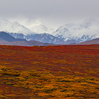
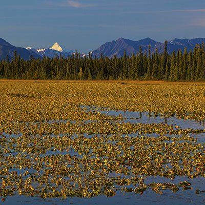
We picked up our tour ticket for the next day at the Wilderness Access Center and stopped by the Denali Visitor Center. They are located at the beginning of the Park Road. The first 15 miles of the Park Road is open to private vehicles. We came to Alaska in late tourism season in September, which sees more rains, but also offers unbeatable view of fall colors and tundra field. A couple of miles into the park, we found ourselves surrounded by the seemingly endless red and purple sea of tundra. Tundra is dwarfed shrubs adapted to the short growing season. They blossom in August and turned to brilliant colors in the fall.

Denali National Park, Alaska
Tundra panorama in Denali National Park dotted by spruces, Alaska
Denali National Park, Alaska
Fall color of Denali National Park, Alaska
Denali National Park, Alaska
Fall color of Denali National Park, Alaska

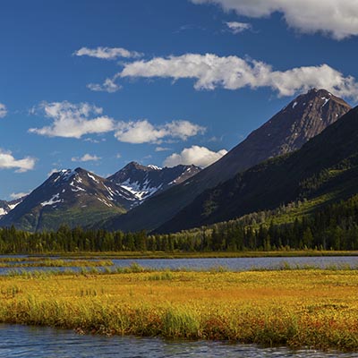
It’s a good decision to see the park first. It started raining at the time we turned back at about the 12 mile mark. Our lodge, McKinley Village Lodge, is 7 miles south of the park entrance. It’s a large facility with multiple buildings. The lobby was warm and cozy. The lodge was built along the Nenana river bank. One of our rooms got the river view.

The section of Nenana River where McKinley Village Lodge is located, Alaska

Our Denali National Park bus tour started at 7:30am the next day. We waited at the Wilderness Access Center half an hour before the shuttle bus came to pick us up. We chose the tour that reaches Eielson Visitor Center that is located at Mile 66 of the park road. The round-trip time is about 8 hours. It’s a good duration considering that we had to keep some strength to drive back to Anchorage at the night. The furthest point that the shuttle bus can take you is Kantishna at Mile 92, but most visitors who are willing to go that far probably camp at Wonder Lake at Mile 85.

The sighting is generally better if you sit on the left side of the bus, which offers more open views of the river and the valley on the way going into the park. It’s also more “scarier” when the bus runs on the cliff at some section of the road. On the way back, you would most likely fall asleep anyway. Our guide was funny. He almost keep talking all the way without stop. The tour is somewhat disappointing mainly because of the weather. We had a grey day and animals were rare. We didn’t see Mt. McKinley at the Eielson Visitor Center because of the cloud. (The rangers also kept us inside because some bears were around.)

Denali National Park, Alaska
Tundra in wonderful display as we just passed the check point where private vehicles have to turn back, Denali National Park, Alaska
Denali National Park, Alaska
The park offers hiking options in the total wilderness, Denali National Park, Alaska
Stony Hill Overlook, Denali National Park, Alaska
At Stony Hill Overlook where we should supposedly see Mt. McKinley in a clear day, Denali National Park, Alaska
Denali National Park, Alaska
Only tundra no taiga near Eielson Visitor Center, Denali National Park, Alaska
Bears, Denali National Park, Alaska
A bear with her two cubs, Denali National Park, Alaska
Bull Moose, Denali National Park, Alaska
A Bull Moose near the entrance of Denali National Park, Alaska

We returned to the Wilderness Access Center a little before 4:00pm. We left the park immediately – we had 240 miles to drive to get to Anchorage. The rain stopped and started. It’s raining very hard near Wasilla. Somehow we managed to beat the time to step into the VIP Korean restaurant that we liked so much before its close. (We ordered the food while driving as we were approaching Anchorage).

We had some time to stop by the University of Alaska Anchorage in the next day morning, before we took the flight heading home at noon.

2评论

Alaska – Fairbanks

2012.8.30Fairbanks is located in the Alaska Interior, half way between the Gulf of Alaska and Arctic Ocean. It’s second largest city of the state. At latitude of 64 degree north, Fairbanks’ summer sees long hours of sun light, but as it enters September, the daytime is shortened by an hour every week. The winter is long and cold. The temperature can often reach −30 °F. However, locals don’t see it as an inconvenience. They wear heavy coats with only T-shirts inside, so they can quickly adjust to the difference between the indoor and outdoor temperatures.

We came to Fairbanks with very little expectation to see Aurora – the northern lights. The auroral activity was only 1 or 2 for the two nights that we were there. Because Fairbanks is in the central of Tanana Valley, the sky is often cloudy in the night. It’s said that the chance is better if you drive north away from the city and up to the mountains. Some lodges there also offer the Aurora Viewing programs with hefty price. As I knew the chance was very low in September, other than opening the window to watch the sky from time to time, we didn’t do anything.

In the morning, we first went to the Trans-Alaska Pipeline visitor center, which is located only 10 miles north of Fairbanks. The pipeline is one of the largest projects of its kind. Although controversial, it’s truly a man-made wonder and solved many difficulties to deal with permafrost and earthquake faults to being financially and environmentally feasible.

Trans-Alaska Pipeline visitor center, Fairbanks, Alaska

We then went to see the Georgeson Botanical Garden. It’s a lovely garden with many species, which is specially challenging consider Fairbanks’ northern environment. The garden is within University of Alaska Fairbanks’ campus and serves as the field ground to study subarctic horticulture.

Georgeson Botanical Garden, Fairbanks, Alaska
Huge cabbage in Georgeson Botanical Garden, Fairbanks, Alaska
Georgeson Botanical Garden, Fairbanks, Alaska
Different species of wheat in Georgeson Botanical Garden, Fairbanks, Alaska
Alaska Berries, Georgeson Botanical Garden, Fairbanks, Alaska
Berries of Alaska, Georgeson Botanical Garden, Fairbanks, Alaska

We drove back to the main campus of University of Alaska Fairbanks and walked around the Museum of North.

University of Alaska at Fairbanks, Alaska
University of Alaska at Fairbanks’ campus, Alaska
University of Alaska Museum of the North, Fairbanks, Alaska

There are not many choices for restaurants in Fairbanks, but a Japanese Restaurant with a very plain appearance named Ajimi is one of the best.

Our first stop in the afternoon is Morris Thompson Cultural & Visitors Center located in the downtown. There were some informative displays and video here. It’s a good free “museum” to spend a hour or so. After that, we went to the Pioneer Park. It’s a park that was built to celebrate the 100th anniversary of the purchase of Alaska from Russia. Later, some old cabins were moved to the place and it has became a historic park that mimics a gold-rush town and demonstrates living environments of the early settlers.

Pioneer Park, Fairbanks, Alaska
0评论

Alaska – Anchorage to Fairbanks

2012.8.28~29From Anchorage to Fairbanks, we would take Glenn Highway (AK-1) and then Richardson Highway (AK-4 and AK-2). We’d go to Denali National Park later in our trip, At that time, we would go back to Anchorage by the shorter route, AK-3, to complete a loop.

The first 40 miles of the Glenn Highway is the only road access to Anchorage from the north. After this section of the busy road, as we turned east after passing Palmer, the vehicles were getting fewer and fewer. The highway runs along the south side of the Alaska Range and, for the most part, along the Matanuska River. The road is winding and climbs over Eureka Summit at 3,332 ft. There are many pullout places for you to view the beautify valley created by the receding Matanuska Glacier.

Mountain range by the Glenn Highway, Alaska
Mountain range and glacier lakes by the Glenn Highway, Alaska
Matanuska Glacier, Alaska
Matanuska Glacier, about 100 miles north-east of Anchorage, Alaska

The 180-mile Glenn Highway took us almost 5 hours. We stayed over night at Caribou Hotel in Glennallen. Some travelers gave low rating to the hotel, but we found it to be nice and most importantly clean, and the front desk was very helpful too. It’s not cheap, but this is in the middle of nowhere, I don’t think you should expect full facilities.

Mount Drum, Glennallen, Alaska
Overlook Mount Drum from Glennallen at sunset, Alaska
Caribou Hotel, Glennallen, Alaska

The next morning, I went back 10 miles along the highway and found the beautify lake we passed by the early night. The view was wonderful in the sunrise.

A lake in Sunrise, near Glennallen, Alaska
A lake in sunrise, 10 miles west to Glennallen, Alaska

After having some instant noodles as our breakfast, we were on our way at 9:30am. After 2 miles, we turned left onto the Richardson Highway (AK-4). The highway cut through the Alaska Range at its east end, the view continued to be breathtaking.

Richardson Highway (AK-4), Alaska
Summit Lake on Richardson Highway (AK-4), Alaska
Richardson Highway (AK-4), Alaska
Richardson Highway (AK-4) near Summit Lake, Alaska
Trans-Alaska Pipeline, Richardson Highway (AK-2), Alaska
Most of time, Richardson Highway run parallelly with Trans-Alaska Pipeline. This is one crossing section (63° 44′ 47″N, 145° 50′ 30″W)

AK-4 meets AK-2 at Delta Junction. There are several military bases around the area. Driving through the town, we surprisingly saw a sign as “Chinese Food”. We decided to give it a try. Luckily, it’s eatable. It’s about 3pm, we were 100 miles away from Fairbanks. As we had passed Alaska Range, the view along the road is less impressive.

15 miles south-east to Fairbanks, lies a small city, North Pole, Alaska. After driving the whole day, it felt good to see a meaningful city. Thanks for city’s name, a gift shop named Santa Claus House becomes a popular attraction. We made a stop at the store. It’s a nice place. There was a Santa taking pictures with visitors all the time.

Santa Claus' House, North Pole, Alaska
Santa Claus House, North Pole, Alaska

We reached Fairbanks at around 6pm. We would stay two nights in the city.

0评论

Alaska – Seward to Anchorage

2012.8.27~28The second day morning, we did some souvenir shopping and had a walk in the Waterfront Park before setting off to the Exit Glacier.

Waterfront Park, Seward, Alaska
View the Resurrection Bay from the Waterfront Park, Seward, Alaska
4th Ave., Seward, Alaska
Seward’s main street, 4th Avenue, Alaska

Exit Glacier is the only part of Kenai Fjords National Park that can be accessed by road. It is one of tens of glaciers descending from the Harding Icefield, which covers most of the Kenai Peninsula. From the parking lot, the 3-mile round trip trail can take visitors to the edge of the glacier and the vista point that offers panoramic view of the glacier by the outwash plain. The trail is well maintained and easy to walk. My parents had no problem walking to the wall of ice.

Exit Glacier, Kenai Peninsula, Alaska
Overlook Exit Glacier, Kenai Peninsula, Alaska
Exit Glacier, Kenai Peninsula, Alaska
Cottonwood forest at Exit Glacier, Kenai Peninsula, Alaska

We left Exit Glacier at 2pm and on our way to Anchorage. We made several stops, such as Bear Creek, on AK-9 and tried to watch Alaska Salmon migration, but eventually we had to go west onto the Sterling Highway until Russian River. There is a large campground by the river. . We walked down to the river level. The water is clear and the condition is excellent for sport fishing. Thousands of salmons swam up the stream to the Russian Lakes where they spawn. The part we went to might be towards the end of the salmon runs. The fish had transformed into deep red color and a lot of them were already dead.

Russian River sport fishing, Alaska
Sport fishing at Russian River, Alaska

Returning to the Seward Highway, we had no plan for the rest of the day. We drove leisurely and enjoyed the sunset on this beautiful scenic drive.

Near the junction of Seward Highway and the Sterling Highway, Alaska
Near the “Y”, the junction of Seward Highway and the Sterling Highway, Alaska
By the Seward Highway near Girdwood, Alaska
Near Girdwood by the Seward Highway, Alaska

The next day morning, I got up early to try my luck of viewing Mt. McKinley from Anchorage. I drove west along the Northern Light Blvd. After passing the Earthquake Park, there was a parking lot by the Cook Inlet. It is 150 miles south to Mt. McKinley. They day was clear with a little haze. I could easily see Mt. Foraker on the left and Mt. McKinley on the right. At the height of 20,320 ft., it’s the highest peak of Northern America.

Overlook Mt. McKinley from Anchorage, Alaska
Mt. McKinley (right) from Anchorage, Alaska
Anchorage Skyline, Alaska

Anchorage is a not a big town. The downtown district is taken by souvenir stores, restaurants and a shopping mall. You can pretty much cover them in a half day on foot.

Anchorage Downtown, Alaska
Downtown Anchorage, Alaska
Historic City Hall, Anchorage, Alaska
Historic City Hall, Downtown Anchorage, Alaska
Anchorage, Alaska
A typical souvenir store in Anchorage downtown, Alaska
Resolution Park, Anchorage
Overlook Cook Inlet at Resolution Park, Anchorage, Alaska

We had a lunch at VIP Korean restaurant. The food was excellent, especially to my parents who do not enjoy western dishes. After lunch, we resupplied at Walmart and leave for the second biggest city of Alaska, Fairbanks.

VIP Korean Restaurant, Anchorage, Alaska
Korean dishes at VIP restaurant, Anchorage, Alaska
2评论

Alaska – Kenai Peninsula

2012.8.25~26We went to Alaska with my parents last September. Until I started booked the flights, I realized that, although at the same side of the country, Alaska is quite far from California. Direct flights were very few. We landed at Anchorage airport at 4:40pm. After 40 minutes, we finally got our car and on our way to Seward.

The Seward Highway (AK-1) is the only road leaving Anchorage to the south. Passed Chugach State Park, the first leg of the Seward Highway run along Turnagain Arm.

Chugach State Park, Alaska
By the Seward Highway near Beluga Point, Alaska
Turnagain Arm near Beluga Point, Alaska

After making a big U turn at the tip of Turnagain Arm, the highway wound into the mountains. This was the most scenic part of the Seward Highway. Lakes by the road were absolutely tranquil. The last ray of sunshine diminished gradually from the top of the mountain as we drove into the Sterling Highway split.

By the Seward Highway near Girdwood, Alaska
Lower Summit Lake, Alaska

After the split, which is commonly called as the “Y”, the Seward highway became AK-9. Because we spent a lot of time getting off the car and taking pictures, it’s getting darker as we drove on the last leg of the highway. Finally, at about 9pm, we climbed out of the mountains and were back to the sea level. We had a dinner at Chinook’s near the harbor and we would stay at the Best Western for two nights.

We planned to take Kenai Fjords National Park cruise tour through Major Marine Tours the next day. Tours offered by different companies share the similar routes. They also share information when they saw whales or other marine animals. We booked the 6-hour tour, which took us around Aialik Cape into Aialik Bay. Along the way, we saw Killer Whales, Sea Lions, Sea Otters, Mountain Goats and Alaska Puffins.

Seward Harbor, Alaska
Kenai Fjords National Park, Alaska
Killer Whales, Kenai Fjords National Park, Alaska
A group of Killer Whales hunting collaboratively, Kenai Fjords National Park, Alaska
Sea Otters, Kenai Fjords National Park, Alaska
Aialik Glacier, Kenai Fjords National Park, Alaska
Sea Lions, Kenai Fjords National Park, Alaska
Alaska Puffins, Kenai Fjords National Park, Alaska

A park ranger on board explained the nature history and ecology along our cruise route. We met several young people from China who were travelling America by themselves. They certainly did their research and had better information than us regarding programs, coupons and even where to see bears and salmons. My parents had great time talking with them.

0评论

Tuscany – 佛罗伦萨 – 最浪漫的城市

2012.6.1~2中午稍事休息,下午我们先去佛罗伦萨学院美术馆(Galleria dell’Accademia)参观。始建于1563年,这里是欧洲最早的一所专门教授绘画技法的学校。现在作为美术馆,馆藏最著名的作品自然是米开朗基罗的《大卫》。很多游客和我们一样慕名而来,在门口排起了很长的队伍。不过,给我们印象最深的却是美术馆的庭院中,一尊彩色金发的《大卫》雕像。看来,佛罗伦萨人对自己最精华的艺术作品也不乏幽默。

David, Galleria dell'Accademia, Florence
佛罗伦萨学院美术馆中《大卫》的原作和彩色的仿制品

离开学院美术馆,我们在圣马可广场走了一圈。(这不是威尼斯的圣马可广场,面积不大。)

Florence
以佛罗伦萨和Tuscany的风景为主题,随画随卖的街头艺人遍布大街小巷。
Gelato, Florence
意大利冰激凌(Gelato)店随处可见。

回到主教堂广场的时候已经是下午六点多。太阳的光线在大教堂乔托钟楼精美的红绿大理石立面上逐渐上行,颜色也由明亮耀眼逐渐变暖,给教堂的顶部镀上一层金子般的色彩。

Cathedral and Giotto's Campanile, Florence
佛罗伦萨的主教堂和乔托钟楼
West façade and the dome of the cathedral, Florence
落日下的圣乔凡尼礼拜堂、主教堂的立面以及教堂的圆顶

LP象前一天一样去老桥看Claudio Spadi的表演,而我走在亚诺河上的三座石桥之间,试图捕捉到落日下迷人的色彩变幻。

Ponte Santa Trinita, Florence
天主圣三桥上代表四季的四座雕塑之一 – 《春》
Ponte Vecchio and Ponte Santa Trinita, Florence
从感恩桥(Ponte alle Grazie)看老桥和天主圣三桥
Ponte Vecchio, Florence
从感恩桥(Ponte alle Grazie)看老桥和天主圣三桥
Lungarno Acciaiuoli, Florence
亚诺河边落日余晖下的Lungarno Acciaiuoli大街

回旅馆的路上,经过旧市场(Mercato Vecchio)的时候,白天挤满商亭的凉廊已经是空空如也,只有一个街头艺人坐在台阶上拉手风琴。这是我第一次听到有人用手风琴演奏《四季》和《Canon》这样的古典音乐。他右手在密密麻麻的键盘上飞舞,左手拉动风琴来控制节奏,技巧相当娴熟。

Playing accordion at Mercato Vecchio (The Old Market), Florence
在旧市场拉手风琴的艺人

最后一天早晨,我们去参观佛罗伦萨城最不能错过的一处名胜 – 乌菲兹美术馆。这座世界驰名的美术馆收藏了众多文艺复兴时期巨匠的名作,比如提香的《乌尔比诺的维纳斯》,波提切利的《维纳斯的诞生》和《春》以及米开朗琪罗的《圣家族》等等。大部分的馆藏都来自于美第奇家族的收藏,怪不得前一天我在新圣母教堂(Basilica of Santa Maria Novella)广场看到一幅标语,意思大约是,“很遗憾很多当代收藏家的品味还不如美第奇家族”。乌菲兹美术馆门前的队伍很长。我们在来的那天就请旅馆帮忙预定了门票,所以可以排比较短的一条队。美术馆里不允许照相,但是我还是忍不住给这位疑似穿越的人物画像拍了一张。

Portrait of a Young Man, by Georg Pencz, Uffizi Gallery, Florence
一个年轻人的画像,Georg Pencz作,乌菲兹美术馆
The narrow courtyard between the Uffizi's two wings, Florence
乌菲齐宫两翼之间狭长的开放式庭院,设计师是乔尔乔·瓦萨里(Giorgio Vasari)

离开乌菲齐宫,我们在附近的街道上逛了逛,吃了午饭,才回旅馆。

A restaurant, Florence
佛罗伦萨的一个餐馆。街对面是皮诺曹的专卖店。
Palazzo dell'Arte della Lana, Florence
Palazzo dell’Arte della Lana,这里是中世纪后期,佛罗伦萨最富有的羊毛纺织行会的所在地。

最后一个下午是预留的购物时间。虽然比不上米兰的名气,佛罗伦萨也是世界上重要的时装中心之一。离我们旅馆几个街区的托纳波尼路(Via de’ Tornabuoni)有很多高级时装和珠宝品牌在这里设店,是有名的高尚购物区。

逛街购物实在不是一项轻松的差事。花了两个多小时在那些商店进进出出后,我终于说服LP在傍晚时分前往米开朗琪罗广场。沿着绿树成荫的Viale Galileo,出租车一路登上亚诺河南岸的山丘。因为前面堵车,我们在圣米尼亚托教堂(Basilica di San Miniato al Monte)前下了车。教堂位于佛罗伦萨市区的最高点,是一座典型的罗曼式建筑。

San Miniato al Monte, Florence
圣米尼亚托教堂的内部
Overlook Florence from San Miniato al Monte
从圣米尼亚托教堂门前遥望佛罗伦萨市区。教堂前面的圣门公墓(Porte Sante)葬有不少佛罗伦萨的文化名人。

米开朗琪罗广场是俯瞰佛罗伦萨全景最好的地点。本地人到这里野餐、照婚纱照;游客坐在向西的台阶上,欣赏街头艺人的演唱,等待落日的美景。尽管每天的早晨都是阴天,到了下午,佛罗伦萨的天空就会放晴,我们连续三天都欣赏到美轮美奂的落日。从米开朗琪罗广场向下望,佛罗伦萨的一座座名胜古迹在眼前依次排列,笼罩在夕阳紫红色的余晖中。我们的Tuscany之行有了一个浪漫的尾声。

Florence panorama from Piazzale Michelangelo, Florence
从米开朗琪罗广场俯瞰夕阳下佛罗伦萨的全景
River Arno and Bridges in sunset, Florence
落日余晖中的亚诺河和石桥
1评论

Tuscany – 佛罗伦萨 – 文艺复兴的摇篮

2012.5.31~6.1佛罗伦萨的名胜非常集中,步行都可以走到。我们的旅店(Strozzi Palace Hotel)就位于城区的中心。我们拿到的是旅馆顶层的套间,房间不编号,叫“米开朗基罗”,我们的隔壁是“拉斐尔”。

从我们的旅店走一个街区,穿过凯旋拱门,就到了共和广场(Piazza della Repubblica)。广场上到处是游客和街头艺人,广场周围都是酒吧和餐馆,其中很多是艺术家和学者经常聚会的场所。

Triumphal Arch at Piazza della Repubblica, Florence
通往共和广场的凯旋拱门
Street paint near Piazza della Repubblica, Florence
街头艺人在共和广场附近的街道上作画。他们画完就立刻擦掉,又重新画起。

继续前行走到亚诺河(River Arno)边。我们没有直接走上老桥(Ponte Vecchio),而是沿着河边走到天主圣三桥(Ponte Santa Trinita),从这里欣赏这座佛罗伦萨最古老的桥梁,也是最著名的一景。我们从河的另一侧走回老桥。

View Ponte Vecchio from Ponte Santa Trinita, Florence
从天主圣三桥眺望老桥

时值黄昏,桥上的商店都已经关门。文艺复兴前,这里的商家都是屠户,而现在主要是首饰店和画廊。

Shops at Ponte Vecchio were closed in late afternoon, Florence
老桥上的商店都已经关门。右边的店铺二层是著名的瓦萨利走廊,连接旧宫皮蒂宫

老桥的桥中间有一座本韦努托·切利尼(Benvenuto Cellini)的胸像。胸像周围没有商店,形成一个小广场。很多人在这里欣赏Claudio Spadi的演唱。他和朋友经常在傍晚的时候到这里来表演,久而久之也成了老桥的一道风景。夕阳反射在河水和水边建筑的玻璃上,桥上的行人都笼罩在温暖的阳光中。我们坐在桥栏上至少听了七、八首歌,直到太阳落山才离开。

第二天一早,和往常一样,我6点起床,独自在城里走走、照相。经过几条街道,我先走到新圣母教堂(Basilica of Santa Maria Novella)所在的广场。

Basilica of Santa Maria Novella, Florence
新圣母教堂

接着,我又走到佛罗伦萨的主教堂,百花圣母大教堂(Basilica di Santa Maria del Fiore)。教堂于1296年开始兴建,前后经过100年才建成,但是教堂的主立面一直没有完工。到16世纪,因为觉得主立面的设计与文艺复兴以后的标准相比太为过时,主立面又被推倒。直到19世纪,经过重新设计,由红绿大理石修建,装饰精美的主立面才最终建成。

Basilica di Santa Maria del Fiore (Duomo), Florence
佛罗伦萨的主教堂 – 百花圣母大教堂
The gallery of the Virgin with Child, Duomo, Florence
教堂主立面上圣母和圣婴的雕像
Piazza del Duomo, Florence
主教堂广场
The bronze door of the Baptistry, Florence
天堂之门 – 主教堂对面的圣乔凡尼礼拜堂(Battistero di San Giovanni)的东门,由Lorenzo Ghiberti在1425年设计建成。它常常被认为是文艺复兴的开山之作。

吃过早饭,我们正式开始在市内游览。第一站是领主广场(Piazza della Signoria)。这大概是佛罗伦萨最有名的广场,主要是因为广场周围和佣兵凉廊(Loggia dei Lanzi)上举世闻名的雕塑,比如《大卫》和《强掳萨宾妇女(The Rape of the Sabine Women)》。领主广场不但是佛罗伦萨的政治中心,也是其文艺复兴中心的象征。它的名气也吸引了大量的游客,这应该是我们去过的地方中最拥挤的一个景点。

Piazza della Signoria, Florence
领主广场
Sea horses of Fontana di Nettuno, Piazza della Signoria, Florence
领主广场上的海神喷泉
The Rape of the Sabine Women, Loggia dei Lanzi, Florence
佣兵凉廊内Giambologna《强掳萨宾妇女(The Rape of the Sabine Women)》和《Hercules beating the Centaur Nessus》
Loggia dei Lanzi, Florence
佣兵凉廊内的古罗马雕像和读书的女孩

广场边巨大的建筑是佛罗伦萨的市政厅,又称旧宫(Palazzo Vecchio),顶部高耸的钟楼俯瞰领主广场。走进旧宫,首先是一间富丽堂皇,几乎可以容纳1000人的大厅。我们参观的时候正在举行一个学校的大会。大厅东西两侧的壁画描述的是佛罗伦萨与比萨锡耶纳的战争场面。二层的房间是画廊和展厅。其中很多是乔尔乔·瓦萨里(Giorgio Vasari)的作品。

Entrance of Palazzo Vecchio, Florence
尽管旧宫是共和制的市政厅,但大门上的门牌装饰写着,“基督是王”
Putto with Dolphin by Andrea del Verrocchio, Palazzo Vecchio, Florence
韦罗基奥的《Putto with Dolphin》(复制品),位于旧宫的前厅
Primavera by Giorgio Vasari and aids, Hall of Opi (Sala di Opi), Palazzo Vecchio, Florence
《春》,由乔尔乔·瓦萨里和他的助手完成,位于旧宫的Opi厅(Sala di Opi)
Judith and Holofernes by Donatello, Hall of Lilies (Sala dei Gigli), Palazzo Vecchio, Florence
Judith and Holofernes》, 多纳泰罗(Donatello)的作品,位于旧宫的Lilies厅 (Sala dei Gigli)

离开旧宫,我们沿着乌菲兹宫的长廊走向亚诺河。这也是乔尔乔·瓦萨里的一项创意的设计。他打通了乌菲兹宫靠河的一面墙,从而把封闭的庭院变成公共的广场和街道。过了河,我们走到碧提宫(Palazzo Pitti)。这里曾经是美第奇家族的府邸,现在是一座博物馆。我们并没有进馆参观,而是返回旅馆休息。

From the loggia of Uffizi by Arno river, Florence
从乌菲兹宫河边的长廊遥望老桥
Closer look of Ponte Vecchio, Florence
老桥南侧的外墙
Piazza del Pitti, Florence
碧提宫前的广场
0评论

Tuscany – 锡耶纳

2012.5.30~31从中世纪到文艺复兴,锡耶纳一直是一个富有的城邦,一直在和80公里外的佛罗伦萨争夺Tuscany地区的主导地位。因为佛罗伦萨在文艺复兴时期的崛起,锡耶纳逐渐沦为附属的小城,但是这反而让锡耶纳完整地保留了她中世纪鼎盛时期的风貌。今天的锡耶纳以中世纪的艺术、建筑和宗教文化闻名于世,城市的建设与周围的环境和谐统一。锡耶纳的古城也在1995年被列入世界文化遗产

游客的车辆不能进城。从我们的旅馆到锡耶纳的中心,大约要走15到20分钟。第一天早晨我6点钟起床,步行进城。天光还早,街道上几乎没有什么行人。

Siena
Siena

锡耶纳中心贝壳形的田野广场(Piazza del Campo)是锡耶纳的标志景观。广场的一边是市政厅(Palazzo Pubblico)和曼吉亚塔楼(Torre del Mangia);另一边是欢乐喷泉(Fonte Gaia)。每一年,广场上都会举行两次赛马(Palio)。赛马是锡耶纳人十分重视的活动,它的背后是锡耶纳传统上17个堂区的居民之间的荣誉和竞争。

Piazza del Campo, Siena
田野广场的全景
Torre del Mangia, Siena
从通向田野广场的小路上看曼吉亚塔楼。

走到锡耶纳的主教堂广场(Piazza del Duomo)的时候,早晨的阳光正开始把广场照亮。温暖的金色阳光把教堂周围的建筑投上了一层迷人的色彩。

Museo Archeologico Nazionale, Siena
主教堂对面的Santa Maria della Scala是欧洲最早的医院之一,现在是一所博物馆。

锡耶纳的主教堂是一座罗马-哥特风格的建筑。教堂西立面的设计是中世纪建筑的经典。外墙的下部继承比萨 – 罗马式的建筑风格;而外墙上部的雕像和尖塔明显受哥特式建筑的影响。

Central gable and right tower of the Duomo, Siena
主教堂中间的山墙和右侧的尖塔
Facade statues of the Duomo, Siena
主教堂左侧尖塔上的哥特式雕塑
Facade statues of the Duomo, Siena
主教堂正门上端的精美雕刻

第一天的白天我们去了Tuscany的南部。到第二天早晨,我们才又返回锡耶纳的市内。

Torre del Mangia and Palazzo Pubblico, Siena
田野广场、市政厅和曼吉亚塔楼
The marble loggia of the Torre del Mangia, Siena
曼吉亚塔楼下的大理石凉廊是黑死病退去后建立的
Siena
田野广场边的小店铺

锡耶纳主教堂的门票不贵,买通票可以参观主教堂广场的建筑群。

Interior of the Duomo, Siena
主教堂内殿最引人注目的是黑白两色条纹相间的大理石柱和墙壁
Pulpit of the Duomo, Siena
主教堂内的讲经台由雕塑家皮萨诺父子所建。父亲尼古拉·皮萨诺在这之前完成了比萨洗礼堂的讲经台。这之后,儿子乔万尼·皮萨诺又回到比萨,建造了比萨主教堂里的讲经台。
Stained-glass window in the Duomo, Siena
主教堂的玻璃画窗
The inlaid marble mosaic floor in the Duomo, Siena
主教堂内的大理石嵌画地板
Piccolomini Library in the Duomo, Siena
主教堂一侧的Piccolomini图书馆里色彩鲜艳的壁画
Dome of the duomo, Siena
主教堂的圆顶

如果十四世纪时大教堂的扩建计划得以完成,教堂的面积将会达到现在的两倍。但是1348年肆虐欧洲的黑死病让这一工程搁置下来,后来再也没有开始。游客可以登上未完成的正厅后墙。从这里可以看到锡耶纳的全景。

The dome and the bell tower of the Duomo, Siena
锡耶纳主教堂的圆顶和钟楼
Piazza del Campo, Siena
田野广场

离开主教堂广场,我们在市场广场(Piazza del Mercato)边的Trattoria Papei吃了午饭。

The church of Santa Maria dei Servi, Siena
从狭窄的街道间遥望Santa Maria dei Servi教堂

我们下午离开锡耶纳去佛罗伦萨。两个城市的距离只有80公里,开车一个多小时就到了。我们在机场还了车,打车进城。

0评论