Eastern Canada and Maine – Old Quebec

2013.9.30Early morning is always a good time to explore Old Quebec, or maybe any city. The reflection of early sun glow illustrated the quiet street. Even the most popular Petit Champlain saw no single person, no store opened either. Occasionally, there were other visitors or early runners enjoying the morning, we smiled, said “bonjour” and passed by. It’s a beautiful feeling.

Rue Sainte-Anne in the morning, Quebec City
Rue Sainte-Anne in the morning, Old Quebec

Old Quebec consists of the Upper Town on high land, Cap Diamant, and Lower Town by the St. Lawrence River. They are connected by Côte de la Montagne street.

Côte de la Montagne street, Quebec City
Empty Côte de la Montagne street in the morning, Old Quebec

The Lower Town features some most popular attractions of Quebec City, including Petit Champlain, Notre-Dame-des-Victoires church, Fresque des Québécois and countless small shops and restaurants. It’s very crowded in daytime, but now I was almost all alone by myself.

Petit Champlain in the early morning, Quebec City
Petit Champlain in the early morning, Old Quebec
View Château Frontenac from Rue Sous le Fort, Quebec City
Postcard view of Château Frontenac from Rue Sous le Fort, Old Quebec
Notre-Dame-des-Victoires and Fresque des Québécois, Quebec City
Fresque des Québécois and Notre-Dame-des-Victoires church in Place Royale, Old Quebec

Our morning activities were focused on the Upper Town. Old Quebec is surrounded by the fortified walls. We walked through Porte St. Louis. It’s one of the oldest gates of the ramparts. It had been rebuilt and replaced for several times in its 300 years of history.

Porte St. Louis, part of the Ramparts of Quebec City

The parliament of Quebec City is in a square shape. The main building has a central clock tower stands 52 meter (171 feet) high.

Parliament Building, Quebec City

The Citadelle of Quebec is a fortress built in the early 19th century to protect the city against possible American attack. The fort is in the star-shape, which evolved from the round-shape fortification and provide better defense against cannons. To get to the core, you have to walk around inner walls. We also circled around the fortress along the external premises. I have to say that we were not very impressed, not much to see.

Near the Ramparts of Quebec City
Near the Citadelle of Quebec

We had lunch at Savini Resto-Bar at 680 Rue Grande-Allée East. These are a couple of street blocks with restaurants and hotels outside of Old Quebec wall. Savini offers a fun dining environment, but the food was so so.

We spent the afternoon in Old Quebec, mostly in the Lower Town.

Quebec City
A yogurt store, Old Quebec
Notre-Dame de Québec, Quebec City
Notre-Dame de Québec, Old Quebec
Petit Champlain, Quebec City
A restaurant in Petit Champlain, Old Quebec
Petit Champlain, Quebec City
Petit Champlain, Old Quebec
Petit Champlain, Quebec City
Petit Champlain, Old Quebec

Besides Côte de la Montagne, an easier option to commute between Upper Town and Lower Town is by the cable car connects Cap Diamant and Petit Champlain. We were only a few minutes too late to catch the last car so we had to climb by ourselves. At the back of Château Frontenac, there is a long promenade known as Terrasse Dufferin. Along the riverfront, the boardwalk is 60 meters above the water. It’s a perfect place for a stroll in sunset and overlook the St. Lawrence River.

Overlook St. Lawrence River from Montmorency Park National Historic Site, Quebec City
Overlook St. Lawrence River from Montmorency Park National Historic Site, Old Quebec
Terrasse Dufferin, Quebec City
Terrasse Dufferin, Old Quebec

We had the dinner at Chez Boulay on Saint-Jean Street. The food is inspired by the nordic cuisine. It’s colorful, creative and delicious.

Dinner at Chez Boulay, Quebec City
Dinner at Chez Boulay, a restaurant featuring Nordic cuisine, Old Quebec
0评论

Eastern Canada and Maine – Ottawa and Montreal

2013.9.29Sheraton Hotel is only 3 blocks way from the Parliament. I had my usual walk in the morning, to take pictures before visitors coming and to understand what places worth visiting and how much time we’d need.

As I was walking in the square of the Parliament Buildings, I understand why it’s the most popular attractions of the city. Open settings, grand architecture, dignified buildings, but the most beautiful place was the section between the Main Block and East Block. The trees’ color has started turning. Immersed in the morning fog, it’s quite and peaceful, very different feeling compared to the rigid buildings steps away.

Parliament of Canada, Ottawa
East Block of the Parliament Buildings, Ottawa
Parliament of Canada, Ottawa
Southeast corner of the Centre Block of the Parliament Buildings, Ottawa
By the Ottawa River, Ottawa
Overlook Ottawa River at the back of Centre Block of the Parliament Hill, Ottawa

From the back of the Centre Block, I walked down from the Parliament Hill, By the bridge of Wellington St., steps led me down to the Rideau Canal. The Canal was built at the beginning of 19th century as a preventive measure in case of Americans invasion. It connects Ottawa River and Lake Ontario at Kingston, where we stopped for coffee the earlier night, with 200 km in length. It’s still operated today for leisure use.

Locks on Rideau Canal and the Alexandra Bridge over the Ottawa River, Ottawa
Rideau Canal, Ottawa
Every lock on Rideau Canal is numbered. The lock is strong enough for people walking over it. The canal system is a UNESCO World Heritage Site.
Reflection of the Parliament Hill in Rideau Canal, Ottawa

Château Laurier is a grand hotel with 100 year of history. It’s located right next to the Rideau Canal. I walked along the canal underneath the bridge and climbed up from the other side. I walked over the Confederation Square and returned to the hotel.

Steps by the Plaza Bridge, Ottawa
National War Memorial and Fairmont Chateau Laurier in background, Ottawa

I returned to Parliament Hill with my wife and in-laws 1 hour later. Centennial Flame was lit on. It happened to be the Canadian Police And Peace Officer’s Memorial Day, which is on the last Sunday of September of every year since 1998. We have a chance to view the memorial service in front of the Police Memorium by the Summer Gazebo and watched the parade on the front lawn of Parliament Hill.

Canadian Police And Peace Officer's Memorial, Ottawa
Canadian Police And Peace Officer’s Memorial in front of the Police Memorium by the Summer Gazebo, Ottawa
Parade of Canadian Police And Peace Officer's Memorial in front of Parliament of Canada, Ottawa
Canadian Police And Peace Officer’s Memorial parade under the Peace Tower of the Centre Block, Ottawa
Canadian Police And Peace Officer's Memorial, Ottawa
Canadian Police And Peace Officer’s Memorial, Ottawa

We took the same route that I walked earlier in the morning. We had some breakfast at BridgeHead Coffee, then we had a quick tour around Ottawa‘s Lower Town without leaving our car, partly because of the safety concern but mostly because we’d have another city to visit.

Leaving Ottawa, we soon enter Quebec province. It’s well known that the official language of Quebec is French, but we were still surprised that English just disappeared from all signs. My father-in-law had done researches in France for a couple of years. He could read and speak French, which was very helpful. At one time, we stopped at a visitor center and asked for maps. The lady at the help desk helped us but just like she helped any other visitor; then my father-in-law started talking with her in French – the lady become enthusiastic almost right away. She brought more maps and brochures and told us other attractions worth visiting.

At 2pm, we arrived at Montreal, the largest city in Quebec. Montreal had been the commercial center of Canada until 70’s and remained to be a diversified and active city for commerce, technology and world affairs. However, we only planned to be here for several hour and the only area we’d visit was the Old Montreal.

Old Montreal is a historic area by the waterfront of St. Lawrence River. There are enough parking space by Rue Saint-Antoine behind the city hall. The center of the Old Montreal is the Place Jacques-Cartier square. We walked to the Old Port and Rue Saint-Amable, then we had lunch at one of many restaurants at the square. It started getting dark when we walked to Notre-Dame de Montréal Basilica. We didn’t get a chance to get in.

Montreal City Hall, Old Montreal
Old Montreal
Walking street, Rue Saint-Amable, Old Montreal
Old Montreal
Place Jacques-Cartier square, Old Montreal

We drove to the Mount Royal Park. The very top of the hill was closed to vehicles, so we were not able to view Montreal’s skyline from the top. On the waist of the mountain, there is an vista point. We could overlook the northern part of the city with the Olympic Stadium in sight.

Overlook Montreal from Mount Royal Park, Montreal
Overlook North Montreal from Mount Royal Park, Montreal
A pair of raccoons at Mount Royal Park, Montreal
A pair of raccoons at the vista point. They were very affectionate. Montreal

Our schedule was like group tour that could only taste the city in a very superficial way. We left Montreal at 5:30pm. It’d be a two and half hour drive to reach Quebec city. There were not a lot of car on the highway. We almost passed by Quebec City without noticing the sign. Luckily, we were able to charge the cell phone in the car and load the map.

We located Boulevard Laurier, which led us straightly into the Old Quebec. The street became tree-lined and then the buildings along the street appeared to be more elegant. After we went through a stone arch, the street suddenly became very narrow. Navigating through the European-style maze-like city grid, we checked into our hotel, Hôtel Champlain Vieux Québec. From the window, we had a view of grand Château Frontenac.

Château Frontenac, Quebec City
Night view of Château Frontenac from Hôtel Champlain Vieux Québec, Quebec City

We went out to see if there was any food to eat, but it’s too late and most restaurants were closing. We returned to the hotel, had some nice tea at the lobby. With the hot water, we were able to make our reserved instant noodles as dinner.

Night scene of Rue Saint-Jean, Quebec City
0评论

Eastern Canada and Maine – Toronto

2013.9.27~28Compared with our other travel destinations, a trip to visit Eastern Canadian cities is definitely much less exotic. Our original plan was to go to Puerto Rico, but my in-laws preferred city tours. In the end, we had nice trip. Not only we spent some quality time with the family, but the fall color around Quebec and Maine was the best I had ever seen, and my father-in-law had an opportunity to show off his French speaking skills.

We had a hectic schedule for the first three days. We arrived at Toronto at 10pm on Oct. 27th. Without other customers, it took Hertz an hour to find a car for us, partly because they had to bring a car with an American plate for us as we’re gonna return the car at Boston. The cost was surprisingly cheap though. It’s almost midnight when we checked into our hotel, Westin Harbour Castle, but it’s still early in California time. We had some snacks at the restaurant on hotel’s first floor.

Midnight snacks in Westin Harbour Castle, Toronto
Midnight snacks at the Westin Harbour Castle, Toronto

The hotel is located on the waterfront of Lake Ontario. Although we booked city-view rooms, the one we had was at the corner – The city lights was vibrant seeing from one window, and we had a partial view of the lake from the other.

Toronto Downtown, from the Westin Harbour Castle, Toronto
Toronto lake side view at night, from the Westin Harbour Castle, Toronto

The second day morning, sunrise behind the cloud over Lake Ontario was quite dramatic. As usual, I had a morning walk around the hotel, mostly trying to find out how long it would take to walk to the CN tower. It’s the Saturday morning. Not many pedestrians on the street, but there were a lot of constructions going on under the highway overpass.

Sunrise over Lake Ontario, Toronto
The boardwalk by Lake Ontario, Toronto
Harbour Square, Toronto

CN Tower

I bought a hot-dog on a food stand by the hotel on my way back. After a quick breakfast, we were heading to the CN tower. It’s Saturday, we were worried that the line could be long so we made it our first destination. It’s a 20-minute walk from the hotel. As we got there at 9:30am, there was no line at all. If we hadn’t reserved the tickets online, we could buy the tickets right away. Instead, because I never received the tickets they were supposed to mail to me after the reservation, we had to wait at the entrance for 10 minutes while they were getting our tickets somewhere in the office.

The security check was quite rigorous. As I passed through a security gate, the gate shot out air steams continuously from multiple directions – I don’t know what it’s used for. Like other attractions, right after passing the entrance, there is a photo spot that visitors are photographed against a wall featuring CN tower overlooking the city.

It only takes a minute to reach the LookOut level at a height of 346 meter. Half side of the floor is taken by the Horizons Restaurant. Through the glass window of the other half, the view of the west side of the city and Lake Ontario was fascinating, Unfortunately, we only had the clear view for less than 5 minutes before the cloud moved in. Standing on top of the cloud, we couldn’t see anything.

Overlook Toronto from CN tower

Going one level down, you can walk to the outside and around the tower at the Outdoor SkyTerrace, and have a 360 degree view of the city, but your sight will be cluttered by the wire fence. The most interesting feature of CN tower is the Glass Floor. With a view 342-meter straight down, even I knew it’s absolutely safe, my first several steps were very cautious.

Viewing through the Glass Floor, CN Tower, Toronto

City Hall

We took taxi to the city hall and walked through the square. The city hall was opened in 1965 to replace the old city hall next to it across the street. The architecture is impressive and futuristic, especially considering that it’s built 50 years ago,

Toronto City Hall
Toronto City Hall
The Old City Hall reflected on the glass exterior of Eaton Centre, Toronto

Eaton Centre and Yonge Street

Next to the Old City Hall is Toronto’s most popular tourist attraction, Eaton Centre Shopping Mall. As one of the most successful stores of Eaton’s chain since its opening in 1977, Eaton Centre is so profitable that it’s said that it had been keeping Eaton’s business alive for 20 years until it went bankrupt in 1999. Eaton Centre retained its name and today, it’s still one of North America’s top shopping destinations.

Eaton Centre, Toronto

We made a brief stop at Eaton Centre and walked back to our hotel along Yonge Street. Yonge Street is famed to be the longest street in the world. It’s southern end is mostly taken by bank and office buildings.

Island Ferry

What we planed to do next was to take the ferry to Toronto Islands. The ferry to the Centre Island runs every half an hour, while to Hanlan’s Point and Ward’s Island is once every an hour. The dock is right next to our hotel. We checked out of the hotel and asked the bell desk to store our bags. We planed to take the ferry at 1pm. Although there were already many people waiting before the door was opened, the boat is big enough to get everyone on board.

People get onto Toronto Island Ferry

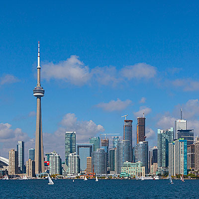
You should go to the second deck and stay at the very rear of the boat for the best view of the city when the ship is leaving for the island. Toronto’s skyline is one of the best!

Toronto skyline, from Centre Island Ferry

It takes about 10 minutes for the ferry to get to the Centre Island. We spend only an hour on the island and walked through the park to the lake shore. Summer had passed. Not many people on the Manitou Beach.

Lake Ontario lakeshore, Toronto Island Park
Shores of Lake Ontario, Toronto Island Park
Toronto Island Park
Toronto Island Park

It’s said that Toronto has the best Chinese food outside of Eastern Asia. It could very much be true. We went to 辛香汇 at Thornhill. Definitely much better than Northern California. There were many new dishes that were recently introduced from China. We ordered a lot of food, there would be no Chinese food in the next several days.

We resupplied at T & T Supermarket (大统华) and it’s well over 4pm as we left Toronto. We’d drive 5 hours and stay overnight at Ottawa. Dark soon fell. We made a stop at Kingston, having a coffee and refreshing ourselves. My father-in-law played Chinese songs stored in his cell phone to keep us entertained for the last two hours of the trip. At almost 11pm, we checked into Sheraton Hotel at downtown Ottawa.

0评论

坦桑尼亚 – 恩戈罗恩戈罗火山

2012.12.31和来的时候相比,道路不再泥泞,很快我们就回到主路B144。三天前,我们就是沿着这条颠簸的石子路开往塞伦盖蒂,现在我们逐渐回到恩戈罗恩戈罗自然保护区的范围。到达恩戈罗恩戈罗火山口的时间是早上九点半。

恩戈罗恩戈罗火山口是在大约两三百万年前的火山喷发中形成的。火山喷发前的海拔高度大约有2700米,喷发后的塌陷使火山边缘的高度将到2300米,高出火山口的底部600米。恩戈罗恩戈罗火山是世界上面积最大、保存最完整的火山口。游客只能从北缘进如火山口,最多只能停留6个小时。

Overlook Lake Makat in Ngorongoro Crater from the north entrance
从火山口北面入口遥望火山口底部的大咸水湖(Lake Makat)
Drive down to the floor of Ngorongoro Crater
驱车从火山口北缘进入恩戈罗恩戈罗火山,下行的时候车辆不许停留。

恩戈罗恩戈罗火山口的直径近20公里,底部面积有260平方公里。由于面积巨大,加上火山口的自然隔断,恩戈罗恩戈罗火山内部形成了独有的自然环境。大约有两万五千头动物在火山口内生存,从不离开火山口;只有一部分角马、斑马和水牛仍然随季节迁徙。有一些非洲草原上的动物在火山口里看不到,比如斑羚、长颈鹿、猎豹和花豹。

Zebras, Ngorongoro Crater
斑马,恩戈罗恩戈罗火山
Lake Makat in Ngorongoro Crater
Lake Makat是季节性的盐湖,湖边有成群的火烈鸟
Buffaloes, Ngorongoro Crater
恩戈罗恩戈罗火山口内的水牛群
Hyenas, Ngorongoro Crater
土狼,恩戈罗恩戈罗火山

恩戈罗恩戈罗火山内生活着一种被世界自然保护组织列为极危的生物,黑犀牛。我们很幸运在这里看到一只,但是距离非常远。黑犀牛的数量在近几十年下降很快,主要原因是偷猎猖獗。偷猎的人为了获得犀牛价值连城的牛角,偷偷捕杀黑犀牛,将牛角割下。坦桑尼亚政府已经采取严厉的措施保护这些频危物种。我们在火山口内经常可以看到持枪巡逻的人员。

Black Rhino, Ngorongoro Crater
远处的黑犀牛,因为身上沾满泥巴,反而看起来很白。
Lions, Ngorongoro Crater
隐藏在草丛里的雄狮

恩戈罗恩戈罗火山的面积之大、视野之开阔都令人震撼。我们在火山底部游览了大约3个小时,然后从火山口的西坡上行,又沿着边沿转了多半圈,回到恩戈罗恩戈罗火山的南面入口。

Panorama view of Ngorongoro Crater from the floor
恩戈罗恩戈罗火山底部的全景
Ngorongoro Crater's own weather
东边日头西边雨 – 恩戈罗恩戈罗火山的天气自成一体

距离我们的飞机起飞还有10个小时。在回程的路上,我们经过了这一路上造访的每一处令人难忘的景点。从东非大裂谷的西缘下来,午后的阵雨如期而至,下了大概一个小时。当我们转到开往阿鲁沙(Arusha)的大路上,雨停了,路边出现一道美丽的彩虹。看起来这一路的好运气会一直陪伴我们到机场。

Tanzania's Staple Food - Bananas, Mto wa Mbu
坦桑尼亚人的主食之一 – 香蕉,东非大裂谷脚下的Mto wa Mbu
Maasai's village, near Arusha
阿鲁沙附近的马赛(Maasai)人的村落
Maasai's market, near Arusha
阿鲁沙附近的马赛(Maasai)部落的集市
Rainbow over North Tanzania plains, near Arusha
北坦桑尼亚平原上的彩虹

就在我们停车拍下这道彩虹之后,一路上都很可靠的越野车突然发动不起来了。这里离阿鲁沙只有五、六十公里,Justin打电话到旅行社,旅行社正好没有多余的车。我们焦急地等待了40分钟,幸好有一辆同旅行社的车经过。司机比Justin有经验,他打开我们的车前盖儿,鼓弄一番,从里面拆下一样东西,车子居然就启动起来。祸不单行,进入阿鲁沙城区的时候,车子的后胎突然爆胎。这时候是下午6点,正是阿鲁沙市区街道最堵塞的时候。当我们换好车胎、驶出市区的时候,已经是七点钟。尽管我们还有足够的时间,但是天已经黑下来,如果再有什么意外,能不能赶上飞机就说不准了。车子向机场缓慢的行驶,我们都有些紧张。

还好,再也没有什么意外发生,我们八点半到达机场。唯一的遗憾是,如果不出这些状况,我们很可能会在到机场的路上看到乞力马扎罗山,而我们看到的只是一个模模糊糊、似是而非的影子,连我们自己都不能相信。我们感谢了Justin一路上给我们的向导。回家的路还有很长。

我们的东非大草原之行远远超过我们的预期。出发以前就知道我们将造访世界闻名的国家公园,看到种类繁多的野生动物,但是我们没有想到会经历如此多样的自然地貌和丰富的人文地理环境。精心安排的帐篷旅馆能够让我们在享受美景的同时,有一个舒适的旅途生活。东非大草原是我们一直向往的旅程,我们终于梦想成真。

0评论

坦桑尼亚 – Ndutu湖和大迁徙

2012.12.30~31从塞伦盖蒂出发到Naabi山,道路笔直地向东南延伸。成群的角马和斑马在公路两侧,一眼往不到头 – 我们正处于塞伦盖蒂草原上动物大迁徙的中央。

每年大约有一百五十万只角马Wildebeests)在塞伦盖蒂草原上迁徙,行进的距离超过一千五百公里。跟随迁徙队伍的还有大量的草食动物,斑马、瞪羚gazelle)和高角羚impala)。 随雨水和草场因季节的变化,迁徙的路线大致有规可循。在年尾的时候,迁徙的动物大都聚集在塞伦盖蒂南部、Ndutu湖和恩戈罗恩戈罗火山保护区一带低矮的草场上。

Wildebeests in migration, Serengeti National Park
迁徙中的角马,塞伦盖蒂国家公园
Grant's Gazelle, Serengeti National Park
瞪羚,塞伦盖蒂国家公园
Wildebeests in migration, Serengeti National Park
迁徙中的角马,塞伦盖蒂国家公园
Mountain Zebras in migration, Serengeti National Park
山斑马Mountain Zebras),塞伦盖蒂国家公园
Wildebeests in migration, Serengeti National Park
迁徙中的角马,塞伦盖蒂国家公园

到达Nabbi山塞伦盖蒂国家公园东南门的时候是中午12点。两天前,站在Nabbi山上远望,周围的草原上还是一无所有;而现在,迁徙中的动物已将我们包围。

Overlook Southern Serengeti and animals in migration from Naabi Hill
从Naabi上瞭望塞伦盖蒂草原,草原上迁徙中的动物成群结队

午后的阵雨如期而至。我们回到车上吃午餐,等待阵雨经过。

Storm is approaching Naabi Hill, Serengeti National Park
午后的雷阵雨正在接近Naabi山,塞伦盖蒂国家公园

从Naabi出发,没过多久我们就离开主路向南。因为行程订得太晚,恩戈罗恩戈罗火山口的旅馆已经被订满了,我们要在Ndutu湖区过夜。刚刚过去的阵雨让地面变得很泥泞,草原上几乎没有明显的道路标记。Justin开车要很小心,免得陷到泥潭里。

Mountain Zebra, Serengeti National Park
打滚的斑马,塞伦盖蒂国家公园

大约过了一个半小时,开阔的草原慢慢退去,我们进入灌木地带。Ndutu湖附近是观赏野生动物迁徙的上佳地点,一方面湖区有充足的水源,迁徙的动物实际上就是跟着丰茂的草场在走;另一方面灌木地带对角马和斑马来说更加安全,不容易被捕食。一月到二月间,大约三、四十万头角马会在两三个星期内生下它们的幼仔。虽然同时生产看起来会让狮子、鬣狗们饱餐一顿,但是它们在短时间内能够吃掉的动物有限,以群体而言,更多的幼仔反而有可能生存下来。

寻找我们的营地花了一点时间。Ang’ata Migration Camp位于草原和灌木间的高地上,营地的主人在介绍如果处理废物的时候说,“after you’ve done your business, we will take your business to the business center and they will be buried underground”,这真是一种幽默的方式来讲述有些难以启齿的事实。

休息片刻我们就再次出发。Ndutu湖附近的灌木丛里是观鸟的好地方。

Bateleur Eagle, Lake Ndutu
Bateleur Eagle,Ndutu湖
Black Kite, Lake Ndutu
Black Kite,Ndutu湖

开始的时候我们一直很小心。为了不陷到泥里,宁可绕点儿远,也不穿过泥泞的湖底。后来Justin从电话听到湖的对面看到花豹,我们也顾不上许多,开车直奔而去。到的时候已经有五、六辆车。花豹看起来不大,我们离的很近,只有不到二十米的样子。

Leopard, Kake Ndutu
在树杈上休息的小花豹,Ndutu湖
Photographer's jeep in Lake Ndutu
专业摄影师和改装过的吉普也来凑热闹,Ndutu湖

回营地的途中,正好看见远处的树林里一队长颈鹿经过,其中两只长颈鹿对峙着打了起来。长颈鹿打架的武器就是它们的长脖子,真的是互相甩开长长的脖子,碰撞、扭绞在一起。很难想象看起来如此优雅的动物动起手来竟然是这么的粗暴,而且我们看到的还只是小冲突,真打起来更加的惊心动魄。

Giraffe fight, Lake Ndutu
长颈鹿打架,Ndutu湖

我们的晚餐是炸tilapia,在中国叫做非洲鲫鱼或是罗非鱼,没想到还真是产于非洲的。

第二天早晨我们七点钟离开营地。Ang’ata Camp位于一片灌木林中央,我们在帐篷的附近看到过长颈鹿和大象。Justin说早晨的时候来过一只狮子,看起来动物们正向这个方向移动。

Ang'ata Migration Camp in sunrise, Lake Ndutu
日出下的Ang’ata Migration Camp,Ndutu湖
Migration, Lake Ndutu
大迁徙,Lake Ndutu湖

当我们离开灌木林回到草原地带的时候,成千上万只的角马把我们所包围。并没有明显的领头者,角马们只是低着头,向着Ndutu湖的方向前进,好像它们知道那里有丰饶的草场和水源在等待着它们。乌云正在南方天空聚集,Ndutu湖那边应该很快就会下雨。完全以大自然的力量所驱动,角马们沿着这条迁徙的路线已经走了上百万年。

Migration, Near Lake Ndutu
迁徙中的角马群,Ndutu湖附近
Wildebeests in migration, Near Lake Ndutu
迁徙中的角马群,Ndutu湖附近
Hyenas, Near Lake Ndutu
鬣狗,Ndutu湖附近

我们最终又回到来时的主路B144上,下一站是恩戈罗恩戈罗火山。

0评论

坦桑尼亚 – 塞伦盖蒂国家公园

2012.12.28~30我们到达塞伦盖蒂国家公园东南门的时间是下午3:20,大门建在Nabbi山的旁边。Nabbi山实际是一些由地下拱出地面的火山石,称为Kopjes,它们的地质年代比塞伦盖蒂草原的土壤要古老得多。塞伦盖蒂草原上零散分布着很多这样的石堆,但是只有在这里游客可以下车攀登巨石堆成的小山。趁Justin去买门票的时间,我们沿着小路走上Nabbi山。山顶上是俯瞰周围地貌的理想地点。塞伦盖蒂的南部是一望无际的草原,非但没有什么起伏,甚至连一棵树都见不到。大迁徙的动物群还没有到达这里,草原的空旷无际让我们惊讶不已。

Endless grassland in south Serengeti, the entrance of Serengeti National Park
塞伦盖蒂南部空旷无际的草原,塞伦盖蒂国家公园的东南入口。

进入塞伦盖蒂草原的公路笔者地向西北方向延伸。大约又开了半个小时,我们看到有十几俩车停在路边,原来是一只雌性猎豹就在离路边六七十米远的地方。

Cheetah, Serengeti National Park
塞伦盖蒂国家公园里的猎豹

我们一边向宿营地前行,一边观看路边的动物。从恩戈罗恩戈罗火山过来都是石子路,路上碰到三个德国来的女孩儿,她们的车胎爆了,只好上了我们的车,先带她们去的宿营地。五个成年人挤在一辆吉普里,都站起来看动物的时候,还真是不太方便。

Saddle-billed Stork, Serengeti National Park
鞍嘴鹳(Saddle-billed Stork),塞伦盖蒂国家公园
Grey-crowned Crane, Serengeti National Park
灰冕鹤(Grey-crowned Crane),塞伦盖蒂国家公园

我们在傍晚7点到达我们的宿营地,Ang’ata Camps。这个营地大概有八到十顶帐篷。位于中央的帐篷比较大,用来做饭厅,还有一个小图书馆。因为位于草原的中央,蚊虫较多,进出帐篷都要拉开关闭拉锁。和我们在塔兰吉雷马亚拉湖所住的豪华帐篷旅馆相比,这里的条件可差多了。不过塞伦盖蒂国家公园距离城市更远,能在如此广阔的大草原上有个舒适的睡觉的地方,应该庆幸才是。

刚到的时候,我们还对挂在每顶帐篷外的两个大桶很好奇,晚上才知道这是为客人洗澡用的。工作人员在远离帐篷的地方生起一堆火,用一个大盆烧热水。等水烧开,再把大盆抬到帐篷附近。用每一个帐篷一个大桶接满热水,挂在帐篷外面,另一个桶装冷水。客人洗澡的时候打开龙头,冷热水混合从大桶流入帐篷里的喷头,就可以洗澡了。在这么偏远的地方,即使看起来简简单单的热水也要费一番周折。当然帐篷旅馆收取的价格也是不菲。

Ang'ata Camps, Serengeti National Park
我们在塞伦盖蒂国家公园住的帐篷,Ang’ata Camps

第二天早起出发。塞伦盖蒂草原在雨季的时候,有很多动物回到南部活动。

Hartebeest, Serengeti National Park
狷羚,羚羊(antelope)的一种,只分布在非洲
Baboon troop, Serengeti National Park
狒狒,狒狒是群居的社会动物,有严格的等级,出行时喜欢排成一列,像一个小分队
Hippos in the pond, Serengeti National Park
河马水塘 – 河马虽然喜欢群居,但不是社会动物
Crocodile, Serengeti National Park
池塘里的鳄鱼

大约10点钟,有人给Justin打来电话。向导们都是互相通信,有什么大型的动物,就能立刻带着客人赶过去。所以茫茫草原有时四野无人,有时又是几十辆吉普一下子聚在一起。

我们赶到的一个小山丘下,这里已经聚集了30辆左右的吉普。小山上有一只母豹带着两只小崽在休息。花豹(Leopard)是攀爬能手,一般都呆在树干或火山岩的高处。这一次,被团团围住的花豹看起来有些紧张,不让两只小豹子走远,不时把它们叼回身边,最后还是躲到岩石后藏了起来。

A leopard with her cubs, Serengeti National Park
花豹和她的两只小豹

从早上一直阴沉的天气开始下起零零星星的小雨。离开花豹所在的火山岩,我们继续走草原上找寻动物。很快我们在灌木丛中看到两只幼狮,一公一母。有趣的是,在灌木后面不远的树林里,不时有长颈鹿和羚羊出没,因为狮子们在它们的逃逸距离(flight zone)之外,这些草食动物一点儿没有警觉的样子。

Young lions with a giraffe in sight, Serengeti National Park
年轻的幼狮,不远处可以看到出没的长颈鹿
Lions, Serengeti National Park
两只幼狮

中午时分,我们返回营地午餐,乌云开始在我们头顶聚集。一场暴风雨就要来了。

Game drive in Serengeti National Park
行驶在乌云密布的塞伦盖蒂草原

吃过午饭,正在和Justin商议出发,大雨开始瓢泼而下。生活在加州,这样的豪雨已经好久未见。浓密的雨幕就如瀑布一般,一刻不歇,帐篷外一片雾蒙蒙的暗黑与青蓝。深积的乌云看起来似乎夜幕已然降临。有时候,远处的天空似乎露出一些亮光,让人不禁期望雨就快要停了;但是不一会儿,乌云就再一次站了上风。

Ang'ata Camps, Serengeti National Park
暴雨中的营地,Ang’ata Camps
Serengeti National Park
雨后的Seronera,Ang’ata Camps附近

直到下午5点,一刻不停地下了三个小时的大雨终于耗光了自己的力气。距天黑已经没有多久,我们也不想陷在泥泞的路上,所以Justin决定就到附近的Seronera看看。Seronera是塞伦盖蒂草原上一个小小的定居点,附近有几个旅馆和营地,还有一个野生动物保护的信息中心。信息中心依着草原中突起的火山石而建,被一圈形状如烛台的大仙人掌般的植物(Candelabra Tree)包围。这里有一个介绍塞伦盖蒂自然生态环境的展览。

Candelabra trees around Seronera Information Center, Serengeti National Park
Seronera信息中心边状似烛台的仙人掌树。

Seronera信息中心里随处可见像猫一般大小,像是啮齿类的动物,初见时真让我们吓了一跳。它们实际上是蹄兔(hyraxes),竟然和大象是近亲,真是难以想象。蹄兔分岩蹄兔和树蹄兔,这里都可以见到。信息中心里的蹄兔已经很习惯周围的人类了,每一个角落和树上都能见到它们都身影。蹄兔又称啼兔,果然是喜欢嚎叫,声音很大。既然不是鼠类,样子也就多了几分可爱,叫的声音可不怎么好听。

A Hyrax eating leaves, Serengeti National Park
Seronera信息中心里的蹄兔

我们在周围稍微转了转,就返回了营地。Ang’ata Camps的晚餐比其他帐篷旅馆简单多了:一个汤,两到三个放在大盘子里的主菜,一般是鸡和蔬菜,然后是面包和米饭。

Buffaloes, Serengeti National Park
Ang’ata Camps营地附近的水牛

第三天早上我们就要离开Ang’ata Camps。和我们同住一个营地的还有一位来自中国的游客,聊了以后才知道,她是30年前在内地非常有名的电影,《火烧圆明园》和《垂帘听政》的主演之一,当然不是刘晓庆。让我们颇为惊讶的是,她的老公虽然是美国人,但是他们的两个儿子的中文却说的非常流利。

Sunrise over Serengeti National Park
塞伦盖蒂草原的日出

在离开塞伦盖蒂的路上,我们又与一群狒狒的小分队不期而遇。成年的狒狒强壮有力,地域性特别强。这只公狒狒向我们展示他的獠牙,警告我们不要靠近。

Baboons, Serengeti National Park
狒狒母子
Powerful jaw and sharp teeth, baboon, Serengeti National Park
公狒狒在向我们示威

斑羚(impalas)是草原上最常见的羚羊,它们常常以性别和年龄分类聚集,这是一群雌性斑羚.

Impala herd, Serengeti National Park
斑羚

途中我们驶入一群河马的领地。河马大部分白天的时间都呆在水里,晚上才出来觅食。不过这一次,几只河马大概是趁早晨凉爽在岸上散步早餐。河马看起来笨拙憨厚,实际上攻击性很强。人们常被它们的外表欺骗,在非洲,河马杀死的人类比其它大型动物都要多。

Hippo, Serengeti National Park
一只河马冠名丛中的河马

没想到高潮是在我们即将离开塞伦盖蒂的时候,这是在草原的南部,面前是一片开阔的平原。一共有9只狮子就在离我们不到20米远的路边,都是母狮和幼狮。开始时草丛中只能看到5只,风吹草低,另外4只也慢慢地显露出来,观看的人都不禁发出低声的欢呼。其中中间的四只一直凝视着远方,Justin爬上吉普车,可是看不到狮子们在看什么。大约过了20分钟,狮子们失去的目标,开始离开。狮子对崇拜自己的人群显然已经习以为常,它们缓慢的穿过吉普车间的空隙,走到另一侧的草原。

Lions, Serengeti National Park
几只狮子注视着远处的猎物
Lions, Serengeti National Park
母狮和幼狮

每一年的年底,迁徙的角马多聚集在塞伦盖蒂国家公园恩戈罗恩戈罗自然保护区之间。两天前我们来的时候,这里还是空空荡荡,迁徙的动物群还没有到达;而现在,我们就处在大迁徙的中心。

Serengeti National Park Map
Map of Serengeti National Park.
0评论

OpenStack Summit Hong Kong

OpenStack is an open-source project for cloud computing. While started only 3 years ago, it’s growing up quickly and started picking up momentums in recent years, together with new tech trends/hypes, such as Virtualization, SDN, NFV and son on. I went to Hong Kong earlier this month to attend OpenStack Summit. It’s the first summit held outside of the US. With more than 3,500 attendees, it’s clear that there were a lot of enthusiasm around OpenStack.

Openstack Summit 2013, Hong Kong

As an OpenStack Network Model (Neutron) contributor, I was mostly in the developer sessions. This is my first time been to the summit. It’s interesting to note that OpenStack community is very much like United Nations. Different companies with different agenda come together to try to find some common ground moving forward. There are powerful companies, but the less powerful ones can dynamically form into groups based on interests so their ideas can be more influential. People here are competitors and colleagues at the same time. Together, many innovations are incubated.

There were a lot of interesting sessions during the summit, so I only managed to go to the city twice in one relatively free day. Taking Airport Express, from the Expo to the city Central is a half-an-hour ride. 九龍, 尖沙咀, 蘭桂坊, 銅鑼灣, 皇后大道, for those names that I heard so many times from Hong Kong movies and TV series, I finally had a chance to see them in person.

I didn’t bring my bulky DSLR, but rented a Fujifilm X100S based on friends’ recommendation. I also for the first time experimented street photography in manual focus mode. I converted the picture into BW in the post-processing. I am totally a newbie in all these 3 aspects (street photography, manual mode and BW pictures).

0评论

坦桑尼亚 – 奥杜瓦伊峡谷

2012.12.28早晨八点离开Tindiga帐篷旅馆,按原路返回。这一次路程显得很短,大约一个小时,我们终于离开颠簸的土路,回到柏油路上。不过Justin告诉我们,柏油路面只铺到恩戈罗恩戈罗火山,过了那儿就全是土路了。

20分钟后,我们来到恩戈罗恩戈罗火山的山脚下。入口前的道路上吉普车排起了长龙,一打听才知道是因为售票系统的计算机down了。入口右手边的售票处里面站满了排队代游客买票的导游,Justin也排在里面。我们趁这个机会参观了游客中心里小的展览。

从等在入口的车队走过去,我发现几乎所有的游览吉普都是Toyota Land Cruiser。据Justin解释是因为Land Cruiser结实易修理,比起Land Rover唯一的缺点就是比较重,雨季的时候容易陷在泥地里。

Safari jeeps waiting to enter Ngorongoro.Conservation Area.
等待进入恩戈罗恩戈罗保护区的吉普车
Stuffed animals in a safari jeep outside of Ngorongoro.Conservation Area.
游览吉普车里的填充动物玩具
Entrance of Ngorongoro Conservation Area.
恩戈罗恩戈罗保护区的入口大门

等了一个小时,计算机修好了,我们终于可以继续前行。恩戈罗恩戈罗火山的东坡比周围的平原高出800米,从印度洋吹来的信风在这里上升冷却,留下大部分的湿气,所以恩戈罗恩戈罗火山的东南坡森林茂密,而西坡的植被只有草原,没有高大的树木。

Dense vegetation in south slope of Ngorongoro crater.
恩戈罗恩戈罗火山南坡的茂密植被

车道沿着火山口的边缘前行。这里的海拔大约2300米。在火山口的南缘有一处观景台,从这里既可以俯瞰恩戈罗恩戈罗火山内侧的火山口,也可以远眺火山外的平原和山峦。

Overlook Ngorongoro crater from its south side.
从恩戈罗恩戈罗火山的南缘俯瞰火山口

我们行程的最后一天将会下到火山口底部,所以今天只是路过。我们沿着火山口行进了半圈,中间路过Ngorogoro Serena Lodge,就建在火山口的崖壁上,可惜我们因为行程订的太晚,没有订到。在火山口的西侧,年降水量比东南侧要少一半,但是还是足够支持富饶的草场,青绿的草原一眼望不到边。Justin说这是坦桑尼亚最富的地区。

Western slope of Ngorongoro volcano
恩戈罗恩戈罗火山的西坡
Overlook the Ngorongoro crater and Lake Magadi.
俯瞰恩戈罗恩戈罗火山口内的马卡特湖(Lake Makat)。这里是通往火山口底部的道路入口。
A Maasai village for tourist near Ngorongoro Conservation Area.
供游客参观的马塞人村落

30分钟后,我们离开主路(B144),掉头向北。草原已经消失,我们的周围只有零零星星的低矮灌木,环境变化之快实在令人吃惊。沙漠般的土地上没有明确标示的道路,我们在路边接上一个看似过路人,把他带到奥杜瓦伊峡谷的入口处。

Oldupai Gorge Entrance
奥杜瓦伊峡谷的入口

奥杜瓦伊峡谷(Oldupai Gorge)的另一个拼写是Olduvai Gorge。1911年德国科学家Wilhelm Kattwinkel发现峡谷里的化石,却误把当地广泛生长的一种野生剑麻,Oldupai,拼写成Olduvai作为峡谷的名字。自从1911年被发现以来,从峡谷两百万年来沉积的岩层中,发掘出大量的原始人类的化石和他们使用的石器,为人类起源于非洲提供了最有力的佐证。

Oldupai Gorge
奥杜瓦伊峡谷

我们在奥杜瓦伊峡谷的崖边吃了午饭,然后听了一个讲座。做讲座的人就是我们从路边捎带过来的。有趣的是一个人在不同环境下的表现会给人带来的印象有这么大的不同,刚才他只是一个风尘仆仆的过路人,而现在他完全是一个很有权威的学者。

游客中心有个小博物馆,介绍了在奥杜瓦伊峡谷和Laetoli的古人类学发现。Laetoli的位于奥杜瓦伊峡谷南方45公里,在那里的火山灰化石中发现了360万年前的原始人类的脚印。这组足迹长约27米,可能是三个原始人类留下的,对脚印的研究发现这三个原始人类是以直立方式行走。脚印的附近还发现了其它动物的足迹。试想在360万年前的一个雨天,一头大象和三个古人类行走在东非平原上,这只大象一定在想,“这三个是什么怪物,居然用两只脚走路”。360万年过去,大象还是大象,而人类已经成为整个地球的主宰。当然那时的古人类和现在的人类还有很多不同,甚至还不是智人的直接祖先。博物馆有一张地图,描绘了智人(Homo sapiens)走出非洲的时间线路

Vegetation of Oldupai Gorge
奥杜瓦伊峡谷的低矮植被
Common Bulbul, Oldupai Gorge
Common Bulbul,奥杜瓦伊峡谷
Agama Lizard, Oldupai Gorge
Agama Lizard,奥杜瓦伊峡谷的彩色蜥蜴

我们下午两点离开奥杜瓦伊峡谷。雷雨好像离我们很近,就在那一排合欢树的后面。

Thunderstorm near Oldupai Gorge
奥杜瓦伊峡谷附近的雷雨

回到B144,我们开始看到一群群的角马(wildebeests)和斑马 – 我们正在走进塞伦盖蒂大草原。

Tunderstorm over Serengeti
塞伦盖蒂草原上的雷雨
Zebras in migration near Serengeti National Park
塞伦盖蒂草原上迁徙的斑马
0评论

Portland, Oregon

2013.8.3~4We arrived at Portland at early afternoon. We first checked into the hotel near the airport then drove into the city.

We parked the car near North Park Blocks. The city center around W. Burnside Street and downtown didn’t impress me. The street is noisy. The famous Powell’s Books is a very busy store, with a lot of books and a lot of people, but the surrounding still made me feel a bit run-down.

Powell's Books, Pearl District, Portland, OR
Powell’s Books, Pearl District, Portland, OR

We walked along SW Stark Street towards downtown. We had a cup of coffee at Stumptown Coffe Roasters and stopped by several interesting shops. The perception I had about Portland is quite different from other American cities I’ve been to, but I can’t explain what it is, the way people dressed, the style that stores are arranged, just somewhat different. It’s said that Portland is the new magnet for hipsters. Maybe that’s where my feelings came from.

A bike sculpture, Burnside and 13th Av. intersection, Portland, OR
SW Stark St., Portland, OR
Street view from Stumptown Coffee Roasters on SW Stark St, Portland, OR
Jackpot Records, Downtown Portland, OR

We still prefer more modern styles. After asking for direction, we walked towards the shopping district. We had a rest at Pioneer Courthouse Square and felt that it’s where we belong to.

Light Rail, Downtown Portland, OR
Pioneer Courthouse, Portland, OR
Street food carts, Portland, OR
Street food carts. (CNN declared Portland home to the world’s best street food).

We had dinner at Yama Sushi & Sake Bar in Pearl District. This seems to be a high-end section of the city. The arrangement of streets, stores and parks are well considered and organized. According to explorethepearl.com, “the Pearl is clear validation that high-quality, inner-city communities can revive from the ashes of urban decay”

North Park Blocks, Portland, OR
Jamison Square, Pearl District, Portland, OR

We left the city by NW Fremont Bridge. Overlooked the city by the river from this direction, it’s lovely and alive. My original impression had changed.

The next day morning, we drove along the Columbia River and went to see Multnomah Falls. Only 30 minutes from the city, the park offers quite magnificent view of this two-step waterfall.

Multnomah Falls, Oregon

We plan to visit the city again before flying back home. However, northbound highway 84 was shutdown for road construction. All the local roads were quite jammed. We eventually gave up and had a lunch at Thai Seasons restaurant. One side of wall is dedicated to the restaurant’s mission statement writing on the blackboard, to buy local and to be environmental friendly.

We left the city at afternoon and concluded our 4-day trip to Mt. Rainier and Portland, Oregon. A short and rewarding get away.

0评论