2012.5.27~28Italian consulate’s office in San Francisco was very small and the officers sometimes were quite arrogant, luckily we got our visa without any issue.
Consulate General of Italy, San Francisco
We arrived in Florence at 4pm local time. At the airport car rental counter, we got a free car upgrade. It turned out not as ideal as it sounds, the bigger car caused us some headache while driving and parking in those hill towns at Tuscany. Our first destination is a small town 50 miles west of Florence, Lucca, After a little more than an hour, we checked into our hotel, Hotel Ilaria & Residenza dell’Alba.
Lucca, Italy
Lucca, Italy
Lucca, Italy
Lucca, Italy
Lucca, Italy
Lucca, Italy
Lucca, Italy
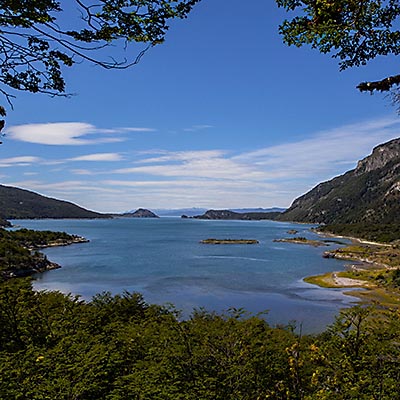
The hotel is located in the old town enclosed by Lucca’s historical walls. I had a walk around the city right after we settled down. Via Santa Croce run right through the middle of the inner city from east to the west. It was late afternoon. I only got time to cover the southern part of the old town.
Piazza del Giglio, Lucca
Piazza XX Settembre, Lucca
We had dinner at Ristorante Giglio at Piazza del Giglio. Grilled fish and Octopus are some of the local favorites.
The next day morning, as usual, I had a morning walk by myself before the breakfast. Lucca is famous for its narrow lanes winding among the medieval buildings and suddenly opening to small piazzas at one side of the streets. Morning sunshine provided some intriguing lighting condition for photography.
Via del Fosso, Lucca
Via del Gallo, Lucca
Piazza San Martino, Lucca
Via Antonio Vallisneri / Via del Battistero / Via delle Trombe, Lucca
The hotel serves the breakfast at an open patio that overlooks the garden of a villa at back of the hotel. After the breakfast, our city tour officially started.
Via del Fosso, Lucca
People watching, Lucca
Anfiteatro Romano
Piazza San Frediano, Lucca
San Michele in Foro, Lucca
Lucca as seen from the top of the Guinigi tower
Lucca’s inner city is quite small, but our legs got really heavy after walking back and forth in those narrow alleys. As usual, after lunch we went back to hotel to take a nap and resumed our tour again at 4pm.
Walls of Lucca
Piazza Napoleone, Lucca
Duomo di San Martino, Lucca
Sculpture on Duomo di San Martino, Lucca
Via Fillungo, Lucca
Piazza San Michele, Lucca
Much more compact, quiet and slow-paced than Florence and Pisa, featuring beautiful medieval architecture and maze-like lanes, Lucca is a jewel of a Tuscan town, a surprising treat of our Tuscany trip.
2012.1.8The next day morning, we went to see the Obelisco de Buenos Aires. It’s located in the intersection of avenues Corrientes and 9 de Julio. Spanning seven lanes on each direction and 2-lane byway on each side, Avenue 9 de Julio is the widest avenue in the world. Only two blocks away from the Obelisco, Teatro Colón is considered to be one of the best opera houses in the world. Unfortunately, the theater was in renovation, we didn’t even have a good look of it from the outside.
Obelisco de Buenos Aires
Still traumatized by the incident the earlier day, my wife asked me to explore the city by myself in the afternoon. The taxi first took me to the Plaza Dorrego at San Telmo. A short walk lead me to the small plaza that is surrounded by beautiful two-storied buildings. It’s Sunday. The plaza was taken over by stands selling all kinds of antiques. This is Buenos Aires’ most famous flea market, Feria de San Pedro Telmo. Everything selling here must date before the 1970s.
Plaza Dorrego, San Telmo
Plaza Dorrego, San Telmo
Plaza Dorrego, San Telmo
Plaza Dorrego, San Telmo
Plaza Dorrego, San Telmo
Plaza Dorrego, San Telmo
I spent about an hour at Plaza Dorrego then took taxi to another legendary place of Buenos Aires – El Caminito at La Boca. This is a short pedestrian street overcrowed with restaurants and shops, but what draws visitors and photographers here are the houses painted in vivid colors. They are predominately in blue and yellow, which are the colors of the Boca Juniors football team. Although the street is crowed by visitors having their good times, there was no single visitor could be seen immediately out of the area – La Boca’s crime rate is among the highest of the city. Even within the tourist area, there were many police on patrol to keep the street safe at least in the daytime.
Caminito, La Boca
Caminito, La Boca
Caminito, La Boca
Caminito, La Boca
Caminito, La Boca
Caminito, La Boca
Caminito, La Boca
Caminito, La Boca
Buenos Aires is a such elaborate and culture-rich city, two days was not enough to cover it all even in the most superficial way. We didn’t got chance to visit Palermo and Belgrano, the upper-class side of the city. We left Buenos Aires in the evening and concluded our 16-day trip.
It’s already nine months and two more trips later as I finished the last installment of the travelog. The legacy of this unparalleled journey is that wherever we go, we always think, “we have been to Antarctica, nothing will surprise us”. However, the fact is, the world’s beauty and diversity have never stopped amazing us in every unexpected way. With an open mind and keen eyes, we will never feel bored of travelling.
2012.1.7Buenos Aires was the last stop of our entire trip. It’s certainly cannot be called “the last place on earth”, as it is the most visited city in South America. This is what the consul told us as we applied for the tourist visa at Los Angles, “Buenos Aires is different from other Latin America cities. It’s a little bit Spain, a little bit Italy, ….”. Argentina was one of the richest countries in the world back in the beginning of the 20th century. Its prosperity attracted large amount of immigrants from Europe. They brought in their cultures and greatly influenced the growth of the city. From the grand buildings and broad avenues, to lovely sidewalks, cafés, bookstores and parks., no wonder Buenos Aires is often referred as the “Paris of South America”.
Avenida Roque Sáenz Peña
However, Buenos Aires is not immune from the problems of big cities. Especially after the collapse of Argentina economy 10 years ago, unemployment, poverty and economic inequality led to high crime rate. Ten years after, the economy is recovering and street is much safer, but crime is still a big obstacle of Buenos Aires.
We got to our hotel, Esplendor Buenos Aires, well after the midnight. The hotel is one of the oldest hotels in the city and located at the heart of the Microcentro district. It’s right next to Galerías Pacífico mall. Florida Street, Plaza de Mayo, Plaza San Martin and Obelisco are all within the walking distance.
Painting Decor in Esplendor Buenos Aires
The next day morning, the street was still very quiet at 10am. We first walked to Plaza San Martín. The plaza has a park and several monuments and memorials within its perimeter. It is surrounded by some beautiful buildings, including the famous Kavanagh building.
A Café at Plaza San Martín
Monument to José de San Martín, Plaza San Martín
Palacio San Martin, Plaza San Martín
Monumento a los Caídos en Malvinas and Kavanagh building, Plaza San Martín
Returned to where we lived, we went to Galerías Pacífico. Compared to the noisy Florida Street jammed by stall shops, Galerías Pacífico offers a more elegant shopping environment. Centro Cultural Borges can be accessed from the second floor of the mall. Besides art exhibitions and auctions, it also hold year-round tango shows in very low price.
Galerías Pacífico
After a short break at the hotel, the plan for the afternoon was to see the other side of Microcentro district. We first went to the Florida Street (Calle Florida). It’s so famous that we felt we were obliged to see it as least, however, neither the environment nor the style of shops were what we like, so we just walked through the street without making any stop.
Florida Street in the morning
We then spent sometime around Plaza de Mayo. In the height of summer of Buenos Aires, it’s a hot and humid day. We stopped at a Café on Ave. de Mayo. As we just sat down, my wife found her iPhone was not in her bag. Knowing pick-pocketing is quite common in Florida Street, we almost left everything in the hotel, but the only thing my wife brought couldn’t survive being stolen. My wife understandably got very upset, so we returned to the hotel directly.
Plaza de Mayo
Plaza de Mayo
Our evening program was the Tango Show at La Ventana. Argentine tango is originated in Buenos Aires. From the tango school to the tango shows, from the street dance to Milonga filled with locals, this city takes tango to her heart. I am specially attracted by the tempo of tango music. I originally talked to one of services that would take guests to several popular Milongas to experience more authentic tango, but eventually, considering that we were the first time visitors without any tango knowledge, we chose the more entertaining tango shows. It’s a little touristy indeed, for example, the part that actors sung “Don’t Cry for Me Argentina” and waved the Argentina flags in the middle of the show, however, I could see the passion and pride they put into the program. I was deeply moved when the old man who created and run the show for many years was introduced. He played accordion on the stage for the rest of the show. Since then, I was particularly fascinated by elder Argentine men when they are singing, dancing or playing instruments, as I can perceive a sense of elegance that can hardly be found in Argentina’s turbulent recent history.
Tango Show at La Ventana
Tango Show at La Ventana
The tango show started at 10pm and ended at almost midnight. To Porteños, this is only the beginning of their night lives. Leaving the theater, walking on the cobblestoned street, I began to comprehend the magic of the city. Our taxi drove along the Puerto Madero. The light decorated the building and the river, the dark concealed the graffiti and trashes on the street. Buenos Aires is a more beautiful city to watch while riding a taxi.
2012.1.6I booked a tour to see Tierre del Fuego National Park on our second day at Ushuaia. Knowing that the scenery is not as dramatic as TDP, my wife preferred staying in in the city to do more shopping.
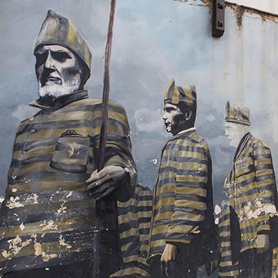
The guide met me at hotel at 8:30am, then he went around the city to pick up a family from Australia and two Argentines. Our first stop at the park was a railway station. Besides offering a steam locomotive tour, the station has a major theme of its prison history. The city of Ushuaia was first created mainly as a prison because of its remote location. At the first half of the 20th century, Argentine government expanded the town around the prison to increase its population and to enforce Argentine sovereignty at Tierre del Fuego. This is why posters and paints of prisoners can be seen everywhere in Ushuaia.
End of The World Train, Tierra del Fuego N. P.
Southern Fuegian Railway Station, Tierra del Fuego N. P.
Southern Fuegian Railway Station, Tierra del Fuego N. P.
All of us were more interested in natural beauty so we skipped the locomotive tour and directly went into the park. The next stop was Ensenada Bay, we had a short walk on the coast of the Beagle Channel and the surrounding hills.
Ensenada Bay, Tierra del Fuego
Around Ensenada Bay, Tierra del Fuego
The tour took us to the Roca Lake. It’s located at the border between Argentina and Chile and offers one of the most beautiful views in the park. We walked along the lake to the visitor center. I got an opportunity to shot a group of Black-necked Swan.
Roca Lake, Tierra del Fuego N. P.
Roca Lake, Tierra del Fuego N. P.
Roca Lake, Tierra del Fuego N. P.
Driving south, we made a brief stop at Green Lagoon to overlook the lake in the turquoise color and the trees damaged by the beavers.
Green Lagoon, Tierra del Fuego N. P.
The highlight and the final stop of the tour was Bahia Lapataia. The guide stopped the car at a trail head and let us walk over the hill. The trail leads to a parking lot that marks the end of National Route 3. This is the most southern end as far as the road runs.
Lapataia Bay, Tierra del Fuego N. P.
The end of the Panamerican Highway, Tierra del Fuego N. P.
We bumped into our co-passengers of the Antarctic cruise from time to time on the street of Ushuaia and we met many of them at the airport. It’s an interesting feeling that we came from all over the world, spent several days together in such a surreal place and now we would return to whoever we are. At the check-in counter, Aerolineas Argentinas told us the flight “is ONLY delayed by 50 minutes”. We would arrive in Buenos Aires at the midnight.
2012.1.5In the morning at 7am, the ship reached the pier in Ushuaia. Our journey in the Antarctic came to the end. We would spend the rest several days in Argentina.
Ushuaia Port
We checked into Alto Andino Hotel. It’s a little bit off the main road, small but very well built. It’s still too early to get a room, so we left our luggage at the hotel and walked to the city center. Ushuaia is the capital of Tierra del Fuego Province and often regarded as the southernmost city in the world. However, compared with Punta Arenas, which is a fully diversified city, Ushuaia’s main function is the gateway for researchers and tourists to explore the Southern Ocean.
Ushuaia
Ushuaia Signpost
Ushuaia really has only one main street, San Martin. At one end of the street, there is a Chinese restaurant, Arco Iris (Rainbow) restaurant. The owner came down from Buenos Aires to manage the restaurant by herself. They run a good lunch buffet and also offer traditional Argentine BBQ. However, we asked the chef to make a special order of tomato soup noodle. It was HUGE. After eating western dishes for more than a week, we finally had a real Chinese comfort food at the world end.
Arco Iris restaurant
There were many booths around the port selling cruise tours to the Antarctic region. The lowest price of the similar tour like ours was $3500. Only the backpacker can take advantage of this low rate. We stopped at several museums and Souvenir stores, but for the most of the day, we just took time and rested at the hotel room.
Ushuaia Street Drawing
Ushuaia Street Drawing
Ushuaia Street Drawing
Ushuaia is famous for its spider crab dishes. Living in the cold water in Beagle Channel, Spider Crab is a similar species to Alaska King Crab. We had the dinner at La Cantina Fueguina de Freddy on San Martin. The crab was fresh and tasty, but we are still in favor the dishes at Brocolino in Punta Arenas.
2012/1/3 ~ 4Roaring forties, furious fifties and screaming sixties are the names given by the sailors to the strong westerly winds found in the Southern Hemisphere. Drake Passage, notorious for its rough, often violent, sea, spans between the latitudes of 50 and 60 degrees. We will take two days to cross it.
Drake Passage is about 500 miles wide. It’s estimated that the passage was opened around 20 to 40 million years ago. This ‘event’ not only isolated Antarctica from other continents, but also made the unimpeded flow, Antarctic Circumpolar Current, possible. The current keeps the warm water away from Antarctica and further cools down the continent. Many researchers believe it is a major factor of the glaciation of Antarctica. Where the warm and cold water meet, named Antarctic Convergence or Polar Front, sees a sharp change of the surface water’s temperature and forms a significant biological boundary. As the cold water sink, upwelling of deep water bring substantial amount of nutrients and nurtures abundant Krill, which results in food chains supporting fish, whales, seals, seabirds and other species.
The Captain
The first day on the Drake was quiet and eventless. The whole day was dedicated to lectures. In the morning, Jolande spoke about the Race to the Pole, the competition between Scott and Amundsen to be the first to reach the South Pole. I learned their stories when I was in the middle school; sailing at the Antarctic and listening to their heroic story, I couldn’t help felting inspired again. I believe a lot of people felt the same way, because the whole lecture room was filled by the passengers. After Jolande’s lecture, Lex talked about the whales and dolphins of the area where we had been sailing. After lunch, Jolande gave another talk about the general introduction to Antarctica, including both its geographic features and political status.
The sea was smooth, we were visited only by some Cape Petrels. Petrel and Albatross spend most of their life in flight. Once they grow up, the often fly for several years without returning to the land. Gliding is the most energy-efficient for them to cover the long distance to locate patchy food sources. In fact, their wings are so adapted to glide, when the sea is calm, they are forced to rest on the ocean’s surface and wait for the wind to pick up. We saw this happen several times with these Cape Petrels.
Cape Petrels
Cape Petrels
The second days saw a totally different weather. The wind was getting stronger and the sea was rough. Only a few people showed up in Jolande’s presentation on the life of Edward Wilson. He was a naturalist and artist who went to the South Pole and lost his life together with Captain Scott. Although the lecture room is at the bottom of the ship, we couldn’t stay in our seats because of the rolling sea. Even for me who were never too sensitive to anything started feeling uncomfortable for a while. Lying on the bed soon calmed me down, then I was literally thrown out of the bed by a huge wave.
Huge Waves in Drake Passage
The wind speed reached 60 knots. Not everyone made to the breakfast and lunch. We had to take care of our forks and plates, otherwise, they might fly off the table. One French girl was pushed to the floor and the chain to secure the chair to the floor got broken. The afternoon lecture was cancelled, instead, the film “Around Cape Horn” was shown in the library. The following are two videos I shot on the rough sea. It’s Lex who was making announcement about the film in the first video.
It was foggy outside. We sailed past Cape Horn without actually seeing it. At the afternoon, the wind was still strong but as we closed to the land, Tierra del Fuego, the waves slowed down. We settled our bills on the ship, returned boots and parkas and got our passports back with stamps of Antarctica. Every passengers received an Antarctic Dream’s jacket and a certificate reads,
We hereby certify that while travelling aboard the M/V Antarctic Dream,
XXXX XXXX
has set foot on the Antarctic continent, just as the original explorers that came before him/here. This event took place on,
Brown Bluff 30-12-2011
Neko Harbour 31-12-2011
Captain: Ernesto Barria Expedition Leader: Stefan Kindberg
After dinner, we had a farewell cocktail party. Stefan urged us to come back and revisit this fascinating continent in the future; then, he held an auction of the captain signed navigation chart of this voyage. After a heated bidding war, the Russian family living in the most expensive suite eventually beat the Spanish family living in the second most expensive suite at $2100.
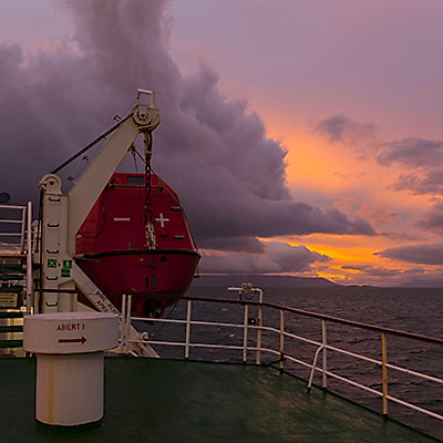
The sun returned by the late afternoon, I finally saw a sunset after several days. We’ve reached Beagle Channel. The captain stopped the engine. We would wait there until the next day morning to get to the port of Ushuaia.
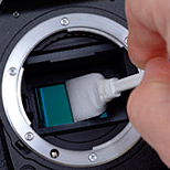
A general rule of cleaning DSLR sensor by yourself is, not to do it! If you insist however, here are the steps to follow to increase your chance of success.
Have the sensor swab ready. They often come with different sizes that fit different camera sensors.
Clean the lens (front and back) and mirror first using Air Blower and LensPEN.
Set the lens to Manual Focus (MF) mode, set Aperture to 16 and ISO to 100. Take a picture of a sheet of white paper. Double check if sensor cleaning is required.
Remove the lens from the camera. Use the configuration menu to set the camera to Sensor Cleaning mode – now the mirror should lift up.
A couple of sharp blasts from the air blower to dislodge the dust.
Apply no more than 3 drops of cleaning fluid to the swap. This is very important – the residual of water is much worse than the dust.
Don’t blow air to the sensor after cleaning. It only gets dust onto the sensor instead of removing them.
Place the swab on one end of the sensor, put enough pressure to bend the swab, move one direction across the sensor and return for another across.
Turn off the camera to close the mirror, put on the lens and shot another picture to see the result
I was frightened by what I saw after using the first swab. It’s much better after 7 or 8 tries. Finally after the 11th swab was used, I got a clean sensor.
2012.1.2We got a very early wake up call this morning. By 5am, we were approaching Deception Island.
Day 4 Route
Deception Island is the caldera of an active volcano. It is called Deception Island because, looking from the outside, it just appears to be a normal island; but it has a narrow opening that leads to the inner water, the island is actually a ring. The narrow opening is called Neptune’s Bellows, which is only 230 meters wide. The wind was strong. It took a bit of caution to navigate through.
Neptune\'s Bellows, Deception Island
Our landing spot is at Whalers Bay. Up the hill is called Neptune’s Window. It is a gap in the volcano rim. It’s about 100-meter high and most of us walked up and had a look of the outside of the caldera. Some Cape Petrels with their chicks nested on the cliff.
Neptune\'s Window at Whalers Bay, Deception Island
Look out from Neptune\'s Window, Deception Island
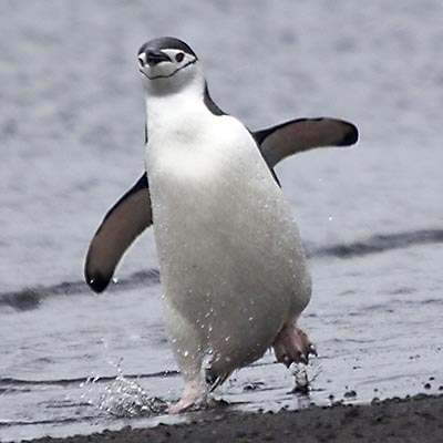
Deception Island has several Chinstrap Penguin colonies. As we walked down from the hill, several of them just swam back to the beach from the sea. With a black band under their heads, they are by far the most cute-looking penguin we’ve seen.
Chinstrap Penguins, Deception Island
Chinstrap Penguins, Deception Island
Strange creature on the beach, Deception Island
Further down on the beach, it’s the remnants of the old whaling station. The station was closed in 1930s’ as the supply of whales was almost exhausted. A serials of volcano eruptions in 1960s’ destroyed most of the station. Now a day, Deception Island has become a popular landing site of the Antarctic cruise. One of the activities is to make a warm bath by digging into the sands. In a better day, some water temperature can be very hot near volcanic area. It was a cold and gloomy day with a cutting wind, but there were still a few brave ones dare to dashing into the sea.
Gloomy weather at Deception Island
Whaling Station, Deception Island
Whaling Station, Deception Island
We went back to the ship at 8am. After the breakfast, Lex gave us a presentation about the history of the whaling industry. Blue Whales were abundant in nearly all the oceans on Earth until the beginning of the twentieth century. Especially in the Antarctic region, at the time of 1966, when whale hunting was banned, the number of Blue Whales has been reduced to 10% of its original population in 1900. Without the industry killing so many whales before the ban, whale watching wouldn’t be a tourist program as whales would be much easier to be seen in the sea.
After the lecture, most people went back to the room to get some rest. A Northern Giant Petrel followed our ship very closely. The way to distinguish it from the Southern Giant Petrel is that it has a red bill, while the Southern one is in green. Only people in the dinner room got chance to see it. Against the wind, gliding through the snow, sometimes it flew high above the ship, sometimes almost touched the wave. Its wings spanned 2 meters and never flapped. Watching it fly, I saw calm and determination.
Northern Giant Petrel
After lunch, Stefan and the captain decided that our second planned landing of the day, Fort Point, had to be cancelled because of the weather condition. The wind is strong around the coast of Greenwich Island in the South Shetland Islands. Lex gave another talk about the seabirds of the Drake Passage. He is an active supporter of the Save The Albatross campaign. By the dinner time, we sailed into the Drake. We were now out in the open sea.
2012.1.1“Good morning! Good morning! Good morning!”. This is the third time that Stefan woke us up in the trip.
Day 3 Route
It’s 6am. Although it’s still quite cloudy at where we were, at the horizon where the mountains pierced through the cloud, we could already see the blue sky. We were sailing towards Lemaire Channel. Suddenly, the ship shook with clashing sound. “Did we hit the iceberg?” Yes, we did, but small ones. Disc-shaped ice floes covered the sea as far as the eye could see. With the strengthened hull, the ship crashed through the pack ice.
Lemaire Channel, Antarctica
At 7am, we sailed into the Lemaire Channel. The channel is about seven miles long and one mile wide. We had not seen the blue sky for 3 days but we were so lucky that we had a beautify day when we were sailing at the most beautify route of our voyage. No one on the deck made any sound. We just watched these breathtaking mountains and their reflections over the tranquil sea gliding through our eyes.
Lemaire Channel, Antarctica
Lemaire Channel, Antarctica
Lemaire Channel, Antarctica
Lemaire Channel, Antarctica
Our first intended landing site was Peterman Island, this would be our southernmost landing site of the trip, and the southernmost Gentoo Penguin colony. However, after we sailed out the Lemaire Channel, the Captain and Stefan decided to turn around because there were too much ice in the sea and it’s very unlikely we could reach the islands. As the ship was making the turn, we spotted a Leopard Seal at starboard. We got a quite good look at it but the seal was not impressed by the ship. It looked up, turned and went back to sleep. Don’t be fooled by its innocent look and lazy moves, Leopard Seals are the top predators in the Antarctic water.
A Leopard Seal at Lemaire Channel, Antarctica
A Leopard Seal at Lemaire Channel, Antarctica
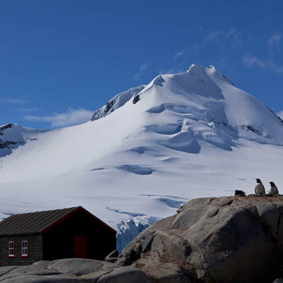
We arrived at our next landing site before lunch. Port Lockroy small harbour that was used as whaling station after it was discovered in 1904 and later used as a military base for British government during WWII. The station was renovated and converted to a museum by the United Kingdom in 1996.
Port Lockroy, Antarctica
Port Lockroy, Antarctica
Volunteers from UK come here and spend the summer in the station. At the time we visited the harbour, there were 4 ladies living in the station. Our zodiac took them to the ship and had a lunch with us. We were all very curious about what they do for their everyday lives. In fact, telegraph is the only way for them to communicate with the outer world, no radio, let alone TV. There is no running water and no boat for them to even reach the nearest island, so they must melt snow and reserve water. The only chance they can have a shower is to get on the tourist ship like ours. I guess during the summer time, tourist ships visit the harbour quite often so at least they can have decent meals occasionally. When asked why she chose this job, the lady at our table answered, “I wish to make some deference.” I don’t know how much this is from her heart and how much it is because of the politically correctness, but it is a respectful task she is taking as an individual.
Port Lockroy, Antarctica
After lunch, we were first taken over to Jougla Point to see some Gentoo Penguins and Blue-eyed Shags – their backs are also in black and underparts are white, look quite similar to Penguins. The beach has a reconstructed whale skeleton and offers a perfect view of the harbour and surrounding mountains.
Port Lockroy, Antarctica
A Gentoo Penguin, Port Lockroy, Antarctica
Blue-eyed Shags, Port Lockroy, Antarctica
The Whale Skeleton on the beach of Jougla Point, Port Lockroy, Antarctica
From Jougla Point, the zodiacs took us to Goudier Island, where the British base is operated. Besides a museum and a souvenirs store, the base also has a post office in operation. Many people bought, wrote and posts cards from the southernmost post office of the world. The sun was shining. It’s a gorgeous day.
The Southernmost Post Office, Port Lockroy, Antarctica
The British base at Port Lockroy, Antarctica
The British base at Port Lockroy, Antarctica
Port Lockroy, Antarctica
We left Port Lockroy at 4pm and sailed north through Neumayer Channel and then entered Gerlache Strait for our next destination, Deception Island.