Islands – Valparaíso
2014.3.22It’s midnight when our plane landed at Santiago airport. Hilton Garden Inn is only 15-minute-drive away from the airport. Its free shuttle took us to the hotel. Both the facility and the room of the hotel were pretty new. We had a good sleep.
While planning the trip, we were quite struggled if we’d go to Valparaíso. Some reports say that, because Valparaíso is a port city and the city has been run down for many years, the safety issue seemed to be worse than those big cities in South America.
We figured we had to have a guide if we went there. Several tripadvisor recommended a local guide named Michael Arnold. We got in touch with him through his website and we connected in Skype. He reckoned our concern but assured us that it’s a manageable risk and touring the city with a local made it much safer than wandering around on our own. It turns out that Michael’s guide made our visit safe, fun, and at the same time, we learned a lot about the city. We can’t recommend his service enough.
We also thought back and forth about how to get to Valparaiso from Santiago. Private transportation is expensive. It would cost more than $300 round trip for two of us. In the end, we followed Michael’s suggestion to take the bus. Taxi took us to Pajaritos bus station the next day morning at 9am. The staff at the bus station didn’t speak English, but bus routes and their schedule were clearly marked. There are two major bus companies, Turbus and Pullman Bus, operating between Santiago and Viña del Mar through Valparaiso. We purchased the round-trip (ida y vuelta) tickets for 8500 Peso ($15) per person from Turbus.

The bus ride was comfortable and we felt very safe as well. It took one hour and twenty minutes to get to Valparaiso and only made a couple of stops. The bus entered the city through its main avenue, Av. Argentina. A large flea market held in the median strip of the street. Later Michael told us, it’s a good place to loss your wallet.

We met our guide Michael at the bus station. He immediately took us to the ticket office and confirmed our seats on the returning bus. Walking out of the station, Micheal told us that several days ago when he took a group of visitors for a walk during a tour, their stuff left on the bus were stolen. He’s not sure if the bus driver he had hired had anything in it, but he felt his own reputation was hurt. He checked our carrying bags to make sure they were secured. I could see he was always alert when we were out of the car and walking. He said he has been keeping a pepper spray in his pocket since the incident.
In fact, we had a very good experience throughout the tour. Michael is a German who has been living in Valparaiso for many years. He talked about the city’s tradition with great pride. The first stop he took us to is a hat shop, as Michael put it, one of many shops that try hard to retain their identities of the prosperous past. My wife bought a lovely owl necklace in the store and immediately got cheered up.

We walked along Av. Argentina towards the port. Port of Valparaiso is surrounded by hills from the south. On our right, behind a supermarket, there is a cable car, funicular or ascensore called by locals. Because of the steep hills, many areas of Valparaíso has no public transportations. The funicular railways connects the downtown and the lower slopes of the surrounding hills. There are 26 funicular railways in Valparaiso, but only a few still operate now.


We walked to the parking lot on the roof of the supermarket. While overlooking downtown and port of Valparaíso from the roof, Micheal showed us some paintings and photographs of Valparaíso’s past. The history of Valparaíso shares the similar trajectory of another city we had visited by the Magellan channel, Punta Arenas. Valparaíso used to be an important port for ships traveling between Atlantic and Pacific oceans by crossing the Straits of Magellan. It’s economical, geopolitical and cultural center of Chile at its golden age, from 1848 to 1914. However, the opening of the Panama Canal in 1914 greatly reduced the number of ships taking that route. City’s economy had been running down since then until the turn of the 21st century.

Michael drove us through the city center. Francia is one of the major avenues of the city. It led us to the other side of the valley. The narrow streets winds around the waist of the hill. We parked our car near Iglesia Las Carmelitas (Las Carmelitas church).

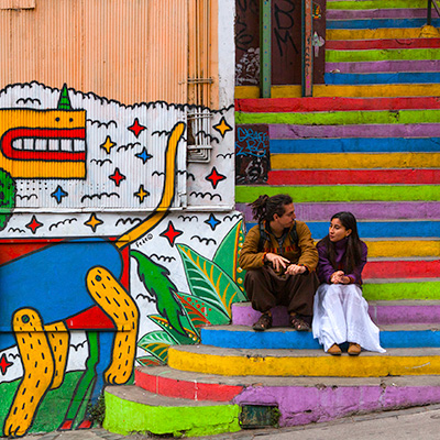
Walking on the hilly streets of Valparaíso, you will soon be amazed by abundant street art on the wall, some are just graffiti, some are quite creative and some are really arty. At the foothills of Cerro Bellavista around Rudolph area is especially popular, thanks for “Museo a Cielo Abierto” (Open Air Museum) project. The idea was formed in 1969 by a group of art students led by Professor Francisco Méndez Labbé. Many paints were created but the project was put on hold because of the political situation in Chile. In 1991, this open museum finally came into reality. Twenty murals were painted on the wall between Ricardo de Ferrari and Héctor Calvo. Many artists who had painted these murals had become world famous at the time.


Unfortunately, all murals have been damaged, in various degree, not only by weather but by vandals. Now they are under strict protection.


We walked back to Guimerà and stopped at a restaurant and a small gift shop on our way.


We got on the car and drove to Cerro Concepción area. We had our lunch, an empanada and a chicken soap, at a local restaurant. We found that we like South American food much better than North American ones.

This section of the neighborhood is booming. Many streets are under construction, old houses are turning into fancy hotels, tens of restaurants and art galleries are opened to attract people from Santiago to spend a day or tourists just get off the cruise ship. Paseo Gervasoni, a broad pedestrian walkway, stands out of other narrow and colorful streets of the area. It is surrounded by old mansions. Local artists come here to display their paintings and crafts everyday. It’s a nice place to overlook the city, the port and the sea.


Valparaíso is a famous place for bike racing. The Valparaiso Cerro Abajo Race is legendary. Bikers bike down from top of the hill to the sea in just matter of minutes. A perfect sport for GoPro comercials. (I actually saw one on our flight.)

The clear sky in the morning became cloudy in the afternoon. We walked all the way down to Plaza Sotomayor. The plaza is a landfill. The coastline was at Sotomayor Avenue in front of the Chilean Navy building. In the center of the plaza, it’s the monument that honors soldiers at navy battles during the War of the Pacific between Chile and allied Peru and Bolivia. According to Michael, Chilean guides could spend hours there.
, Plaza Sotomayor, Valparaiso")
We took Ascensor Concepción back up to the hill. This is the first funicular railway of the city, starting operation in 1883.


Murals are everywhere, on almost every house of every street of Cerro Concepción neighborhood. I’ve never seen a city this colorful. Valparaíso would be a paradise for photographers and walkers if it could become safer.


We caught our returning bus at 3:40pm at the very last minute. Michael told the bus driver to let us off the bus at a earlier station closer to the hotel, instead of going back to Pajaritos. Back to the hotel, we learned that we actually had an extra hour because daylight savings time has ended during our 10-days journey. We wish we could spend this extra hour in Valparaíso. We are so grateful to our guide Michael who made our last day of the trip a wonderful experience.


, Papa Vaka, Easter Island")


, at Puna Pau, Easter Island")


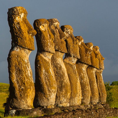
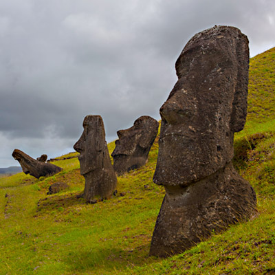
 from Ahu Tongariki, Easter Island")


, Easter Island")


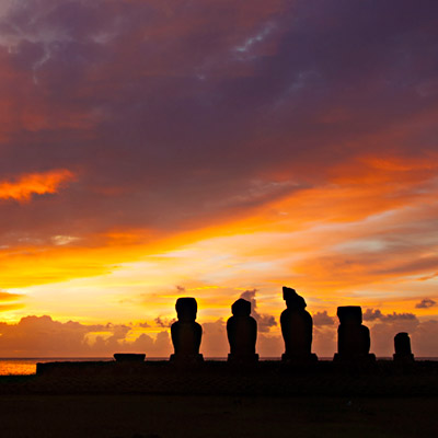
 and Tahai at sunset, Easter Island")