2021.9.28
The plan for today was to drive to Silverton and enjoy the fall colors along the way. There was still time to do something around Telluride in the morning. Several of the famous hiking trails do require hours to finish, so I decided to find a trail to run around the area.
The Galloping Goose Trail starts just outside of Telluride, near the fork of Route 145. It follows the San Miguel River, soon turns into the South Fork San Miguel River. While the scenery is not as impressive compared to what I saw on the mountain yesterday, the origin of Galloping Goose has an interesting story to tell.
During the mining boom of the 19th century, there was a railroad connecting Ridgeway, Telluride and Durango. The remains of the station still stands at the point where the San Miguel River meets. In the 1930s, when the mining industry was declining and many related industries were closing down, the RGS company, which operated the railroad, came up with an idea. They replaced some of the freight train with gasoline-powered railcars and turned the railway that transported ore into a tourist route. The name Galloping Goose came from the fact that the cars kept swaying back and forth as they drove through the mountains, and honking sound of their horns.

I took a rest after the run. It was already noon time when we arrived at Dallas Divide. The hillside was colorful but the sun was to bright. It was not a good time for photography. I didn’t expect the weather and scenery to be completely different at the same location a few hours later.

We stopped at Ouray to have lunch and looked around those old buildings off the main road. While we were stadning in front of the old courthouse, an older lady was taking pictures next to us. With an excitement on her face, she told us that in the movie “True Grit”, this was the door that John Wayne walked out from the courthouse. She must be a big fan of the western movie star. She told us that there is also a bar called True Grit in Ridgway that is worth visiting.


We wanted to have a quick lunch and head to Silverton, but ended up spending a long time waiting for our meal at a cheap Thai restaurant. By the time we left, it was after 2:00 and clouds were gathering in the sky. It looked like the rain was coming. After leaving Ouray, the road started winding up the mountain. By the time we reached the viewpoint of Bear Creak waterfall, the rain was already pouring down. The mountains in the distance were hidden behind the dark cloud, it’s raining quite heavily.

The name “Million Dollar Highway” has been given to the stretch of highway 550 between Ouray and Silverton, and some say it is because of the high cost of building the road; others say the dirt used to fill the road contains gold ore and is worth a lot of money. This section of the road is known as one of the most beautiful roads in the United States because of its treacherous terrain and beautiful scenery. Along the “Million Dollar Highway” slowly, one side of the road is high mountains, the other side is no guardrail cliffs. Because of the rain, the road was slippery, and there were stones rolling down the mountain. We probably had the worst weather in the best of seasons, and despite the stunning autumn colors, I didn’t dare to be distracted, especially when driving on the outside, I was really nervous.
There are several continuous S-shaped turns in the highway, and the rows of aspen trees on both sides go up the mountain, you really cannot see how unique it is in the photo. There is a small lake called Crystal Lake about a third of the way out, and the hillside from near to far is completely covered with golden aspen trees. It is very imposing even in the misty rain. If the weather is good, it would be nice to have a walk in the mountains.


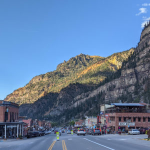
After crossing the Red Mountain Pass of 11000-feet elevation and taking a big switchback, the road opens up and the rain slowly stopped. After an hour driving, we arrived in Silverton. The small town is located in the valley of Animas River, surrounded by several mountains of nearly 14,000 feets. Highway 550 continues southward, and there are two more high passes to reach Durango.

Silverton’s history is similar to Ouray and Telluride in that both started with mining and slowly moved into tourism. Silverton is a bit smaller than the other two cities, perhaps because of the heavy mountainous terrain. For outdoor lovers, it is an ideal starting point for backcountry sports.
We walked along the main street of Silverton and tried to find a cafe or something to warm us up. The time was around 3:30 pm and only some souvenir stores were still open, all the restaurants and cafes were closed. After walking back and forth for a while, we found a restaurant on a side street that was still open. The clerk said there was still some coffee left in the kettle. A cup of hot coffee was enough to cheer us up. Old photos of Silverton and posters of western movies of the 50s and 60s hanging on the wall. It’s like walking back to the history standing in the restaurant.


It didn’t rain much on the way back, and since I had already done it once, the drive didn’t feel so terrifying. At the top of Red Mountain Pass, there is a remnant of a trestle used for mining, from which you can see the magnificent fall colors of the surrounding mountains. The mine ceased operations in 1979, and the reclamation project has been underway since then. The mine has been preserved as part of the local history as well.


It was still cloudy when we were at the Ridgeway, but it gradually cleared up as the road slowly ascended. I wondered if the rain would bring the snow on the mountains. As we were approaching Dallas Divide, I looked into the distance at the San Juan Mountains at the left. There was snow on top! It felt like a dream come true. I stopped the car and took several pictures of the beautiful fall colors with the background of the snowy mountains.

Dallas Divide’s parking lot was already crowded with people, tripods lined up along the fence. There is only one photographer standing on top of his car. He had the best location and view point. It was barren dry and hot in the noon and nothing on the mountain tops, a few hours of rain made the mountains covered with snow. The photographer’s passion and admiration to the nature is best reflected in this photo.


By the time we got back to the hotel it was after eight o’clock. We looked around the mountain village and couldn’t find a restaurant in our liking, so we decided to have dinner at the restaurant in the hotel. We ordered flat bread with different toppings. It turned out that the dish was so huge that can feed at least two more people. The taste was still quite good.