Close Up of Flowers – Filoli
Shooting macro with Fujifilm x100s at Filoli.
[justified_image_grid preset=c1 ng_gallery=88]
0评论
六月 2, 2016

Shooting macro with Fujifilm x100s at Filoli.
[justified_image_grid preset=c1 ng_gallery=88]
2014.11.1今天上午的计划是登巴黎圣母院的钟楼。前一天在旅馆吃早饭的时候,墙上悬挂的照片吸引了我。那是西岱岛和圣路易岛在晨曦中的景象,清冷、安静,却令人神往,让我也忍不住想试一下。
早晨七点从旅馆出发,沿着塞纳河边一路上行,走过大主教桥,前方就是圣路易岛。圣路易岛上名胜不多,以住宅区为主。岛的西端面向左岸的一侧是一排临河的住宅楼,河畔是一列耸立的桦树,是一处常常出现在照片里的景致。这里河岸的人行道很宽,有几处可以驳船的码头。前一天是万圣节,大概也是有人庆祝的,河畔上很多酒瓶的碎片。我在这里照了几张照片,但是都不太满意。大概是取景角度太低,而且也没有那种清冷的感觉。


吃过早饭,我们于九点半赶到巴黎圣母院,排队等待登上钟楼。在我们前面大约有三十几个人。十点钟楼开门,一次大概放进十几个人;到十点二十左右,终于轮到我们。

从北钟楼的入口沿螺旋形的楼梯上行,就到达两座钟楼底部的走廊。这里距离地面46米,巴黎的全景尽收眼底。天空万里无云,虽然不适合摄影,但是正合适远眺。从左到右可以看到的著名景点有,圣叙尔比斯教堂、荣军院、埃菲尔铁塔、拉德方斯新区、圣礼拜堂、歌剧院、圣厄斯塔什教堂、圣心教堂和圣雅各伯塔。

这一条连接南北钟楼的走廊上最有名的要算是栏杆转角处的怪兽雕塑。它们栖息于钟楼之上,用最好的视角注视着千年来这座城市的事世变迁。由于早晨逆光的缘故,怪兽在照片里都比较暗,也许在傍晚或阴天的时候才更适合拍照。走廊很窄,上方有钢丝网保护。栏杆上雕刻的花饰、卷叶,以及探出的引水兽处处可见。


我们在这一层停留了大约半个小时,然后从另一侧沿着南侧钟楼内的螺旋楼梯登上钟楼的最顶层。钟楼呈方形,中间是隆起的尖顶,四周可以供游人远眺。


从早晨开始排队到游览完毕,大约花了两个小时的时间。我本来对地标建筑登高兴趣不大,但是有蜿蜒的塞纳河美景,又从不同的视角欣赏巴黎丰富的人文景观,登巴黎圣母院塔顶远眺绝对值得一游。
从巴黎圣母院出来,老婆回旅馆顺路购物,我先在圣母院广场又逗留了一会儿,然后准备去蓬皮杜文化中心那边转一圈。


穿过Pont d’Arcole,进入巴黎的第四区。巴黎的右岸一直为政府和贵族所占据。果不其然,过桥后右侧立刻就是巴黎市政厅(Hôtel de Ville)。巴黎市政府从1357年搬到这里,650多年来就再也没挪过地方。继续向北,又是巴黎典型的商业街道。路上行人不少,倒也不算很繁华。再走两个街区,就到了蓬皮杜中心。巴黎市中心的主要景点距离并不远。

蓬皮杜中心以暴露在建筑之外的彩色管线闻名。除了现代艺术博物馆,还包括一个图书馆和音乐声学研究中心。其建筑设计颠覆传统,与巴黎古式的风格毫不搭界,兴建初期争议很大。不过这样的例子在巴黎的建筑中并不少见,埃菲尔铁塔和卢浮宫前的金字塔都是明证,而且都已经成为经典。这一次我们没有计划参观现代艺术博物馆,我只是在外面转了一圈,反而觉得紧邻的斯特拉文斯基喷泉(Stravinsky Fountain)更有意思。

斯特拉文斯基喷泉是蓬皮杜中心边的一个大水池,其中点缀着十几座色彩鲜艳的雕塑,或旋转或喷水,代表俄罗斯作曲家斯特拉文斯基(Igor Stravinsky)不同的作品。远处占满整面墙壁的是Jef Aérosol的街画作品,”Chuuuttt”。作者这幅画的意思是希望我们能够花几分钟的时间,透过城市工业的喧嚣,聆听人类自己生活的声音。喷泉后面另一侧是圣梅里教堂(Saint-Merri)。教堂看起来颇为老旧,后来才知道它最近还上了世界文化遗址基金会的濒危建筑名单。教堂外壁在绚丽的喷泉雕塑和诙谐的壁画映衬下显得更为晦暗。

走出蓬皮杜中心附近的小巷,Boulevard de Sébastopol是穿过巴黎市中心的南北向大路。它的起点是位于塞纳河边的沙特莱广场(Place du Châtelet)。其中央的棕榈喷泉(Fontaine du Palmier)和胜利纪念柱是由拿破仑下令修建,用以昭示他在法国对外战争中的赫赫战功。广场的斜对面是圣雅各伯塔,法国大革命前是周围屠户修建的教堂,在法国大革命中教堂被拆除,只留下雕饰精美的塔楼。


与沙特莱广场隔河相望的是位于西岱岛上的巴黎古监狱(Conciergerie),连接两岸的是Pont au Change。早在12世纪,这座桥上就有珠宝商和货币兑换所的商店,桥也因此而得名。Conciergerie中世纪时是法国皇家的城堡,14世纪改用为监狱。作为巴黎最大的监狱,特别是在法国大革命时期,关押过不少大人物。建筑靠近塞纳河的一侧塔楼上,悬挂着一座金光闪闪、美奂美伦的大钟,这是巴黎最古老的公共时钟。


回到旅馆再出来吃午饭已经是下午两点。我们选了西岱岛上新桥边的一家小餐馆,La Taverne D’Henri IV。他家店面很小,走到门口我还不能确定是这一家。咸肉拼盘看起来很诱人,味道也很好。


吃过饭的计划是乘BatoBus去埃菲尔铁塔。午饭时喝了点儿酒,在下午和煦的阳光下不禁有些微醺,也没多想就登上了新桥下出发的塞纳河游船。这也让我们有了一次计划之外又是意料之中的塞纳河之旅。
游船上有广播介绍经过的桥梁和岸边的名胜风景,但是一路并不停船靠岸。从新桥出发,游船先是顺流而下,一直到埃菲尔铁塔,在德比尔哈克姆桥(Pont de Bir-Hakeim)调头。


游船随塞纳河上行,到达新桥时,从西岱岛和圣路易岛的左岸一侧继续前行。我们在网上看到的塞纳河游船的视频,大多是天气阴霾,甚至淫雨霏霏,可见遇到个好天气并不容易。而我们在巴黎多雨的季节,却有个不可多得的晴天。两岸黃色亮眼的梧桐掩映着乳白色的古老建筑,游人在河边岸旁闲坐,船上船下的人都是无比的惬意。


到达奥斯特里茨桥,游船折返,再从西岱岛和圣路易岛的右岸一侧回到新桥终点。


下了船,转头再去做BatoBus,原来BatoBus的登船地点是在右岸新桥下面的河边。BatoBus成人票一天16欧元,两天18欧元,比我们刚刚乘做的Vedettes du Pont Neuf游船还贵,坐的很满,完全不如地铁划算。如果乘船游览塞纳河是必须的旅游项目,建议乘坐专门的游船,再乘地铁去往各个游览点。
BatoBus的路线和Vedettes du Pont Neuf游船一致,但是全程有八个停靠码头,在埃菲尔铁塔脚下就有一站。时间已是下午五点,天色已暗,但是埃菲尔铁塔周围还是很热闹。

等待登塔的游人几乎把埃菲尔铁塔正下方的广场挤得满满当当,草坪上也是人满为患,再加上横七竖八的栏杆,我们走出很远也没有找到适合照相的机会。我们走到草坪一侧布尔多奈大道(L’avenue de La Bourdonnais)上的Le Dôme坐下来喝了一点儿咖啡,店员是一如既往的爱搭不理。休息片刻,再走回埃菲尔铁塔,仍然是灯火通明,人声鼎沸。埃菲尔铁塔登塔的时间一直到午夜,但是九、十点钟就会停止售票。

我们走过耶拿桥到夏乐宫的一侧,这里是远望埃菲尔铁塔最好的地点。每到整点,埃菲尔铁塔会在黄色灯光的背景下,闪烁起千万盏银白色的小灯,持续几分钟,为这个热闹的景点再增添几分活力。

我们沿着塞纳河走到德比利行人桥(Passerelle Debilly),又回到左岸。前面不远就是地铁C线在阿尔玛桥(Pont de l’Alma)的一站。地面上的站台只是一间小屋子,幸好有人指点,我们买了回程的地铁票。二十分钟时间就在圣米歇尔(Saint-Michel)站下车回到旅馆,每人只要1.7欧元,非常方便。

2016.2.11~13First-time visit San Diego downtown, Gaslamp Quarter. What a vibrant town at the night!


2015.12.24This street in San Carlos has the best Christmas light of the valley.
[justified_image_grid orderby=date_asc preset=c1 ng_gallery=87]
2014.10.31今天特意早起,准备去看巴黎圣母院。在楼下的餐厅吃过早饭,我们八点钟就出了门。路过圣米歇尔广场(Place Saint-Michel)的时候,还是冷冷清清。白天这里可是人来人往,车流如织,是法国人喜欢碰头的地方。在照片的右侧就是圣米歇尔喷泉,它有160年历史,名气很大。不过我觉得它颇为破落,颜色暗淡,加上白天人多,很不上像。

不一会儿,就走到了巴黎圣母院。巴黎圣母院位于西岱岛(Île de la Cité)的东端,始建于1163年,从唱诗堂开始,到中殿、西侧面,双塔完成时已是九十年之后。其后,教堂的南北方向的耳堂又经过改建,后殿加建了飞扶壁(buttresses ),直到1345年才完工,前后花了180年。教堂早晨八点开门,游客还不是很多。巴黎圣母院的西立面庄严肃穆、比例精美、雕梁画柱,是法式哥特风格教堂的经典之作;内部装饰却非常俭朴。


问了教堂的工作人员才知道教堂的塔楼要到十点钟才开门。时间还早,我们决定先去参观先贤祠(Panthéon)。从巴黎圣母院到先贤祠直线距离不过一公里,只要沿着圣雅克路(Rue Saint-Jacques)走就好。途中路过索邦大学的侧门,本想照张相,却发现门口排满垃圾桶和修路的路障,只好放弃。

先贤祠位于一个椭圆形广场的中央。我们先沿着左侧走到后面一个三角形的小广场,圣日内维耶广场。广场上的圣艾蒂安-迪蒙教堂(Saint-Étienne-du-Mont)面积不大,先后有几座教堂在同样的位置重建。现在的教堂完成于17世纪初,既有哥特式花窗、又融合了文艺复兴风格的钟楼,建筑特点十分独特。教堂供奉着圣日内维耶的圣骨箱,传说中她在六世纪的时候,保护了巴黎不受匈奴人的侵犯。同样葬在教堂里的还有物理学家帕斯卡(Blaise Pascal )和剧作家拉辛(Jean Racine)。教堂里螺旋形的圣坛围屏(rood screen)花纹精美,非常引人注目。可惜我们来的太早,教堂还没有开门,不能得以一观。

看过《Midnight in Paris》的人应该可以认出这个场景。片中的主人公迷路后,就是坐在圣艾蒂安-迪蒙教堂侧面的台阶上,被一辆老式轿车接走,开始了一段奇妙的穿越之旅。


我们沿着亨利四世中学(Lycée Henri-IV)后面的小路走了一圈,又回到先贤祠所在的广场。先贤祠建于十八世纪中,本来的计划是用以供奉圣日内维耶的教堂,建成时正赶上法国大革命,于是被改为纪念堂,用来安葬为法兰西做出杰出贡献的伟人:伏尔泰、卢梭、雨果、拉格朗日、以及居里夫人均葬于此。这是一座新古典主义风格的建筑,门廊的石柱和山墙与罗马的万神殿(都叫做Panthéon)十分相似。圆顶高七十米。1851年,傅科在这里做了著名的傅科摆的试验来证明地球的自转。


我们沿着圣雅克路往回走,路上开始热闹起来。我们坐下喝了些咖啡,又买了一些小纪念品。


回到巴黎圣母院的时候已是将近11点。等待登上塔楼的游客在教堂右侧排成一条长龙。我们在左岸还要再住两晚,还有时间。


领导先在旅馆休息,我打算去第六区探探路。穿过旅馆后面纵横的小路,很快我就走到圣日耳曼大道(Boulevard Saint-Germain)。大街的这一段与塞纳河平行,是贯穿巴黎左岸的主干道,明显商业气息要比拉丁区更浓。随便一走,就看见一家星巴克,我还以为对咖啡文化自视甚高的巴黎不会有星巴克的市场,后来发现居然还有不少分店。


继续走到卢森堡花园,第一眼看到的美第奇喷泉在正午树影的掩映下让我十分惊艳。如此美景实在不忍独享,我赶快走回旅馆,叫上领导一起上路。我们先在旅馆旁的Khao Thai吃了午饭。这是一家泰式餐馆,和左岸大多数餐馆一样,桌子紧挨着桌子,不容人侧身而过。他家的酸豆鸭肉做的很好吃。对了,在巴黎吃饭如果要白水,莫忘了说要“tap water”。只说“water”的话,肯定拿上来的是瓶装水,要收钱的。

圣日耳曼大道两侧的小巷中,小店的数量只能用无穷无尽来形容,尤其以圣日耳曼大道和卢森堡公园之间的食品商场(Marché St-Germain)周围为最甚。其中最让人感到琳琅满目的当属甜品店。高档甜品店的店面宽敞明亮,装饰得如同首饰店一般。像Un Dimanche à Paris,Pierre Hermé这样的名店门口总是排着队。进了几个甜品店才知道,马卡龙 (Macaron)原来不是Ladurée的专利,每个店都卖。


卢森堡公园始建于1615年,是法国国王亨利四世的王后,玛丽亚·美第奇,在丈夫死后修建的。“美第奇”在文艺复兴时期的欧洲可是赫赫有名的大家族。起家于佛罗伦萨的银行业,美第奇家族逐步渗透到整个欧洲的皇室、宗教和政治势力中。他们不但拥有财富和权力,还特别喜欢资助和收藏艺术品,被称为是文艺复兴的教父。我们在佛罗伦萨的时候就看到过一幅标语,大概的意思是,“很遗憾很多当代收藏家的品味还不如美第奇家族”。这位玛丽亚皇后的一生也可谓跌宕起伏,从宫斗、到摄政、到被自己的儿子流放,亨利四世的被暗杀和她也不无瓜葛。
从卢森堡公园东北面走进公园,第一个看到的就是美第奇喷泉。临路的是一个狭长的池塘,池塘的尽头是喷泉的雕塑。整个建筑被绿树包围,池塘中鱼儿游泳、鸭子戏水,十分的幽静。美第奇喷泉在十九世纪中经过大规模重建,现在看到的雕像都是那时候重新替换的。斑驳的树影虽然看起来很美,但是阳光过强,对摄影反而是个困难。

虽然也是绿树如茵、鲜花满地,但是卢森堡公园在设计上走的不是曲径通幽的路子,而是视野开阔,树木成行,颇有正大光明的感觉,据说是仿照佛罗伦萨的碧提宮所建。卢森堡宫现在是法国参议院所在地。卢森堡宫前的圆形大池塘周边摆放着很多的绿色铁椅,几乎全部被人坐满,看起来以当地人居多。很多家长带着小孩儿在池塘里放游模型帆船。这不过是星期五的下午,巴黎人难道这么的清闲。后来才知道法国是一周35小时工作,也许周末在星期五的下午就开始了吧。

公园的西侧是一片树林和孩子们的娱乐场,比如小马拉车、溜旱冰等等。其间还点缀着近百座雕塑。


卢森堡公园的西北门是卢森堡博物馆,旁边有一家巴黎有名的茶点店,Angelina。位于杜乐丽花园旁边的一家应该是本店。这一家面积很小。Angelina的热巧克力和看起来像面条一样的Mont Blanc最有名。怕太甜,我们只点了一份Mont Blanc和一杯咖啡。

沿着波拿巴街(Rue Bonaparte)往回走,不一会儿就走到圣叙尔比斯教堂(Église Saint-Sulpice)。教堂于17世纪中起建,前后花了130年。最后因为资金问题没有完工,到现在南北钟楼还是不对称的。教堂的面积很大,是巴黎仅次于巴黎圣母院的第二大教堂,但是从西立面来看,要比巴黎圣母院朴素的多。小说《达芬奇密码》中的很多重要情节就在这里展开。


再向北走,又回到左岸最繁华的地区,圣日耳曼德佩区(Saint-Germain-des-Prés)。这里最有名的当属临街的两家咖啡店,双偶咖啡(Les Deux Magots)和花神咖啡(Café de Flore)。这两家咖啡店可算是二十世纪初文学艺术史上的传奇,随便说说都是,这是毕加索坐过的椅子,这是萨特用餐的桌子。不过那是一百年前的事情,现在更像是游客体验生活的名胜罢了。与花神咖啡店一街之隔的圣日耳曼德佩修道院(Église Saint Germain des Prés)是巴黎最早的教堂之一,也是这一地区名称的由来,笛卡儿也安葬在这里。


回到旅馆,离晚餐还有一会儿。我当然抓紧这段时间出去看看夜景。巴黎中心的景点离得都不太远,从旅馆走到卢浮宫实际也就是一刻钟的时间。


卢浮宫广场前方有一座“小凯旋门”(Arc de Triomphe du Carrousel)。从这里望去,可以看到协和广场上的方尖碑,和香榭丽舍大道另一端的凯旋门。这可是等了很久才等到没有人在镜头里。一辆自行车从我身边骑过,车上的人向我喊,“What a city!”。Yes, What a city!

2014.10.30这次去巴黎的主要目的是参加OpenStack的会议。走过世界那么多地方,顶顶大名的巴黎还没有去过。加上会议的时间,我们前后在巴黎计划停留九天。本来以为很充分了,结果象凡尔赛宫等等著名景点还没来得及去。巴黎旅游的内容实在是太丰富了!
因为行程是在十月底、十一月初,本来还担心巴黎的天气会阴冷多雨,结果反而出奇的好。梧桐树叶已经开始变黄,游人相对较少,又赶上巴黎十一月难得的温暖天气。九天中只下了一次雨,也让我们领略了一下雨中的巴黎。是谁说雨中的巴黎才是最美的?
飞机到达戴高乐机场的时间是早晨九点半。打车进城的道路颇为拥堵,到达旅馆的时候已经是十一点多。我们头三天住在Citadines Saint-Germain-des-Prés Paris。酒店位于巴黎的第六区,紧邻塞纳河,就在新桥的对面。从这里前往巴黎圣母院走路不到十分钟,是游览巴黎左岸很好的落脚点。
天气晴好。象往常一样,老婆先在旅馆休息,我出去探路。沿着塞纳河向巴黎圣母院的方向走,经过圣米歇尔喷泉(Fontaine Saint-Michel),继续向前走到小桥(Petit Pont)。这里已经是巴黎的第五区。左手边小桥的另一侧就是巴黎圣母院的广场;右边就是拉丁区的中心。
向右一转,再转入左手一条叫Rue Galande的小街。小街又窄又短,却有着保存完好的中世纪建筑、古式的酒窖和餐馆,当然也有几家手工艺制品的商店。这条街在《Midnight in Paris》和《Before Sunset》里都出现过。


小街左边的一条小路上有一座很不起眼的小教堂,穷人朱里安教堂(Église Saint-Julien-le-Pauvre)。实际上它的历史可以追溯到13世纪,是巴黎最古老的教堂之一。教堂的外观残破,风格也是相当的朴素,与隔岸相望的巴黎圣母院形成鲜明的对比。

教堂的北面小公园叫做Square René-Viviani。如果不是因为一棵有400多年树龄的刺槐,这个公园与巴黎其它的街头公园也没有什么区别。据称这是巴黎早期的居民在这个城市种下的第一棵树。小片的绿地上有人在吃着午餐,中心小广场的喷泉造型相当的奇怪,历史也很短,是1995年才建的。从公园可以遥望隔岸的巴黎圣母院。

公园旁边就是赫赫有名的莎士比亚书店(Shakespeare & Company)了。位于巴黎文化的中心,这个书店却以出售英文书籍为主。上世纪二、三十年代,乔伊斯、海明威经常出没的书店并不在此。这间位于塞纳河边的书店建于1951年,继承了旧书店的风格和名称。我去的时候书店正在举行Jimmy Page自传的签售会,门口排起了长龙。在《Midnight in Paris》的结尾,也有这家书店的镜头。


回到正对小桥的大路,这里人流滚滚,旅游者和当地人穿流不息。Rue Saint-Séverin与Rue Galande相对,却完全没有对面的文化气息。一路上都是餐馆和旅游纪念品商店,韩国、地中海等各国风味的餐馆也挺多。


回旅馆和老婆一起出来,随便在街边的小咖啡店吃完午餐,已经是下午三点。我们先是沿着我中午走过的路线转了一圈。再回到莎士比亚书店的时候,等待签名的人群已经散去,我们得以进到书店里一观。书店内狭窄阴暗,货架书籍到处都是,据说是能够淘到不少别处买不到的书刊。

巴黎的拉丁区位于五区和六区之间。和我们后来住的协和广场附近相比,后者奢华高尚;而拉丁区则是人气旺盛,到处都是书店、咖啡店和餐馆。当地人坐在路边喝咖啡,欣赏过往的人流,完全不顾飞扬的尘土。这里物价便宜,充斥着中低档的小店、餐馆,从来就是学生和文化人喜欢出没的地方。再加上拥有世界上历史最悠久的大学之一,索邦大学(Collège de Sorbonne),孕育了拉丁区自由浪漫的文艺氛围。小资味儿相当浓厚。
西岱岛(Île de la Cité)在这里将塞纳河一分为二,过了小桥就是巴黎圣母院。下午四点,等待进入巴黎圣母院参观的队伍几乎贯穿了教堂前的广场。我们沿着河绕到巴黎圣母院的后面。这里没有拉丁区和教堂广场的喧嚣,是一处安静的公园。从这里可以看到教堂的尖塔和东面的后殿。支撑后殿的肋状骨架曲线修长,充满了动感。这里又是一处《Midnight in Paris》的主要取景点。


巴黎圣母院后面的大主教桥是巴黎最窄的一座桥。其实塞纳河上的每一座桥上都有爱心锁,但是尤其以艺术桥和大主教桥上最多。桥的栏杆已经被爱心锁占满,无处插针。由于锁匙太多,重量太重,甚至造成桥体坍塌的危险,巴黎政府不得不一次性将所有的锁除去。但时间不久,桥上栏杆又被爱心锁挂满。


回到酒店已经是五点多。我们的酒店有一大好处就是大厅里有免费的热水。咖啡馆虽多,也不能总是坐在里面喝咖啡。天色已经开始暗了下来。虽然是在城市,这仍然是摄影的Golden Hour。稍事休息,我就又带着相机、脚架出发了。
法兰西学院(Institut de France)的圆顶虽然算不上恢宏,但是它正对着艺术桥(Pont des Arts),周围非常适合取景。选这一张是因为它包括了很多元素,落日、埃菲尔铁塔、法兰西学院、艺术桥和西岱岛的尖端都在里面。


新桥(Pont Neuf)虽然名字中有个新字,却是巴黎最古老的一座桥。桥面宽阔,桥体桥柱巍然又不失轻灵。新桥实际上是两座桥,将巴黎左岸、西岱岛和右岸连接在一起。夜晚的灯光将桥体完全照亮,倒影在河水里,非常漂亮。

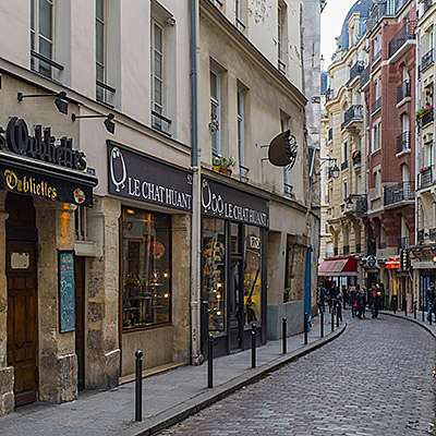
天色已经全黑。我在西岱岛的小巷里乱转,拍了几张不知名的小餐馆。


回到酒店和老婆一起出来吃晚饭。Chez Fernand就在离酒店不远的小巷内,是法式餐馆。味道服务都不错。


2014.4.5I got up in the dark and went to Alto Vista Chapel again. Crosses are erected along the road leading to the chapel. This time, a group of prayers gathered by the road and walking slowing towards the chapel.
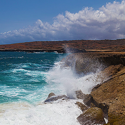
It’s about 5:30am. The sky was cloudy, it’s not possible to see the sun rising on the horizon. The eastern side of Aruba is constantly attacked by trade winds from the Atlantic, waves moved in and hit the shore fiercely. Before the sun rises up, it’s quite foggy by the coast.

I returned to the Alto Vista Chapel. Prayers were sitting on pews, listening to the priest. Isn’t this spiritual?

Our plan of the day was to explore island’s inland and eastern region. The inland of Aruba is almost featureless. The highest hill is only 617 ft (188 m). However, there are several unusual sites of rock formations scattered at the heart of the island. They are unique in that, the rocks, unlike those with volcanic or coral origins allover the island, are monolithic tonalite boulders, rising above the desert soil.
We first stopped at Casibari Rock Formations. Steps were built to allow visitors to climb to the top of the boulder, which provide a panoramic view of the island.


A little to its east, it’s Ayo Rock Formations. The area is bigger than Casibari, with more strange-shaped rocks.


We kept on driving to one of Aruba’s most popular attractions, Natural Bridge. The last part of the road is unpaved, but it’s very easy to drive. The bridge was a formation of coral limestone, spanned more than 100 feet. It actually collapsed 10 years ago, but the view is still impeccable. Facing the open sea at Aruba’s very north shore, with lashing waves crashed over stark rocks violently, against the backdrop of dreamy sky in deep blue color. There were some good photo opportunities.

There is a bar on site overlook the collapsed bridge. A group of tourists came and the guide asked them to line up on top of the bridge. They were singing and dancing and really making a lot of fun of it.


1.5 miles northwest to the Natural Bridge, it’s Bushiribana Ruins, an abandoned gold mill that was once used to process ore from mines in the nearby hills. It’s built in 1825, less two hundred years ago, but probably because of the stark contrast to its surroundings, the ruins invokes feelings of much older history.


Near Bushiribana Ruins on the beach, there is a site where people stacked rocks up, and over time became the Wish Rock Garden. The similar scenes can be found in many places at Aruba’s northeastern coast.

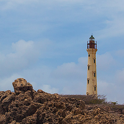
We had the late lunch at La Trattoria el Faro Blanco by the California Lighthouse, then retired to our hotel. At the evening, we had the farewell party on the beach again. My wife’s company was quite generous to reward top performers, but someone has to write a big check for it.

We left Aruba in the second day morning. Most tourists in Aruba are Americans, so Aruba has an agreement with the United States government to have US Customs at the airport. This time, we had the connection flight at JFK airport, and we returned to our home in the afternoon.

2014.4.4In the morning, I got up at 6:30 and went to Alto Vista Chapel to shot sunrise. Someone said watching sunrise at Alto Vista Chapel is a spiritual experience, but it took me much longer time to get there than I though. The sun already rose up.
I drove about a mile north off road. Aruba’s northeastern beach is rocky. I didn’t want to get the tires damaged so I stopped and took some pictures of the rocky landscape. On the surface of the beach, there are a lot of igneous rocks, broken and rugged. The other type looked like coral reef, mostly beneath the surface. They seemed to be composed by narrow and parallel pipes in rock formation.


Returned to the hotel, after having the breakfast, we set off to see some landmarks of the island. Driving to the north, the road runs along the coast. Beaches become quite narrow and sand are coarse. There are no grand hotel anymore. Between Hadicurari Beach and Malmok Beach, not far from the coastline, there is a small shipwreck. A more famous shipwreck is Antilla Shipwreck, located between Malmok Beach and Boca Catalina Beach, further in the sea and cannot be seen from the coast. It’s a popular place for scuba diving.

At the very north tip of the island, it’s California Lighthouse. It’s named after another ship wrecked nearby. Adjacent to the lighthouse is an Italian restaurant called La Trattoria el Faro Blanco. Both the lighthouse and the restaurant sit on a hill. The balcony of the restaurant offers a beautiful view of the western beaches and coastline and golf course Tierra del Sol.


We then visited Alto Vista Chapel, the place I just went to in the morning. The chapel itself itself was undergoing some construction. The surrounding area is semi-arid, almost fully covered by tree-like cactus.


The closest town to Alto Vista Chapel is called Noord, which has only a couple streets. We drove through the town back to the Palm Beach. We saw several Chinese restaurants by the road, but mostly empty. There were even a Chinese supermarket but also seemed closed. It’s said most of grocery stores and supermarkets are actually owned by Chinese in the island.

Near Palm Beach, along J.E. Irausquin Blvd. are the shopping area. We enter a store at Paseo Herencia Mall selling Mopa Mopa Artworks. These are woodcraft, masks, animal figures, boxes, with vivid colors. However, the colors are not painted on. The procedure to make these pieces are quite unique. The buds of the mopa mopa tree are boiled until they become a resin, like a gum. After adding vegetable dyes for the color, the artisans stretch the resin with hands and mouth, yes mouth, to make it into a thin sheet; then, it’s cut and applied to the wood. The tradition comes from Columbia. We bought a small fish from the store.

We went to a beach bar recommended by several locals to have the late lunch. To get to the beach, we have to cross Holiday Inn hotel. I have to say, Holiday Inn as well as Marriott are much more vibrant than Ritz-Carlton.

At the corner of Bubali road crossing island’s main road, L.G. Smith Blvd, there is a supermarket called Super Food Plaze. This is a huge place. It’s the Safeway of Aruba.

2014.4.2~3Less than two weeks after we came back from Polynesia, we were on our way to Aruba again. It was to attend my wife’s company event. We flew a red eye to get to Atlanta in the early morning, then from there, it took only 4 hours to reach this Southern Caribbean island.
This our first time flying over the Caribbean. The color of the sea was mesmerizing.


The bus took us to Ritz-Carlton Hotel, one of the newest and best hotels in Aruba. The organizer explained to us the schedule and all activities and dinner options. We checked into our room at 3pm. There were no activities on the arriving day. We waited in the room for the dinner party.

Aruba is located at the southern rim of Caribbean Sea. Only 18 mile orth of the coast of Venezuela, it is out of the hurricane zone across most of Caribbean region. Days in Aruba are always dry, warm and clear throughout all seasons. It’s sometimes windy because of trade winds from the Atlantic, but the Southwestern coastlines are mostly sheltered by the island. The party started at 6:30pm. There was nice view of the sunset from the Palm Beach.

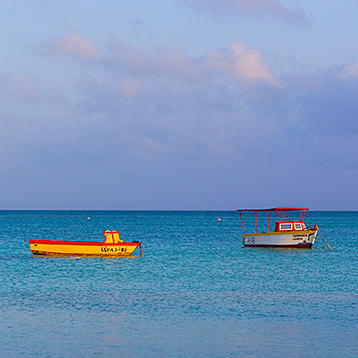
In the morning, I had a walk along the beach. Ritz-Carlton Hotel is located at the north end of Palm Beach, the 4-mile-long beach and high-rise hotel district of the island. There were several boat floating on the shallow water, some good object for photography, but the wave and direction of the light were not perfect.

I spotted a small stingray swimming at the shallow water.
Returning to the hotel, our room had a view of the northern side of the beach. Sea water near the coast are in different shades of blue. There are many water sport related small shops along the beach.


At the time when my wife had the company meeting in the morning, I went to the Hertz office at the first floor to rent a car. The agent tried to persuade me to rent a SUV. According to her, normal cars are not allowed to enter the Arikok National Park and some off-road places. My research before the trip told me that Aruba’s landscape is not that exciting, so I still decided to rent a normal car.
It’s free time after the lunch. We drove to the down, Oranjestad, the capital of Aruba, to do some shopping. Oranjestad is a busy town, tourists are everywhere and traffic is jammed. Aruba’s port is also right next to the town.


After shopping, we thought that we should go to see that other end of the island. We kept on driving to the south. On our way near the south end, we passed a town called San Nicolas, There were some deserted industrial facilities around the town. San Nicolas use to be a bustling town but now is running down.
The very south end of the island is semi-arid, covered by low bushes and dotted with tall cactus. The winding road led to a nice lagoon called Baby Beach. The water is calm and it’s good place for snorkeling.
