2018.7.5
Our boat left early and made its way north along the coast, arriving at the site of today’s activity, Bahía Sullivan, at about seven o’clock. The bay is located between Santiago Island and Isla Bartolomé, with a distance of only 600 meters between the two islands. With the boat anchored in the bay, the iconic pointy Pinnacle Rock of Isla Bartolomé can already be seen. It’s just that you can’t quite see its uniqueness from this angle.


After breakfast, we ascended Santiago Island from Bahía Sullivan. This is a large area of lava field, extending all the way to the sea, without any beach. The lava are generally in two forms, ‘a’a and pahoehoe. The lava at Bahía Sullivan are mostly in the form of pahoehoe, flat and without any jagged edges. In some places the lava looks like a bundle of rope. You can imagine the look of the hot lava slowly flowing, advancing, cooling.


Of course the lava field is not all flat piece, but shows a variety of forms. In some places, a large crack was opened in the middle of the flat volcanic rock, either in a straight line or in a zigzag pattern. The sides of the cracked rocks show brownish-red layer, likely to be iron-bearing. In some places, a bulge rises with an exit in the middle, resembling the shape of a small volcano, and reminiscent of the eggs of the face hugger in Alien. They are the product of small streams of bubbles gushing out of the magma.
Standing in the middle of the lava field, as if in an alien planet. The age of this volcanic rock is very short, only less than two hundred years, the ground does not even sustain plants like cactus, only an occasional clump of weeds can barely survive among lavas.


Out of the volcanic area was a hilly area with brownish-yellow soil, presumably ejected from the ground at an earlier time. Walking between the hills, immediately we felt the heat under the scorching sun. In fact, it’s not very far from the shore. In some places, you can still see the magma had also flowed into this area, cooling and freezing in the valley between the hills. Some shrubs can find room to live in such barren land.


Lunch was served on the boat at noon, and the crew used the limited ingredients to make shapes of ducks and geese. Probably too cute, no one wanted to touch them, and they were served back after the meal.

The afternoon activity was the ascent of Isla Bartolomé. The zodiac took us around the Pinnacle Rock at the edge of the island. The rock were formed by an underwater volcanic eruption and then collapsed to form the unique shape of the pointy top today. Behind the rock is a cave that is home to Galapagos penguins. As we docked, we saw several penguins swimming in the bay.

We picked our way up the wooden walkway and soon reached the top of the 114 meter high hill. At the top of the mountain is a small red lighthouse, with a flat open space a few steps below. From here, you can look forward and see the most iconic landscape of the Galápagos Islands. Isla Bartolomé is shaped like a pear, with its long stalk deep into Bahía Sullivan. The pinnacle rock is located on one side and are only then revealed in their full glory. On either side of the shank is a half-moon shaped beach, and in the distance is the black lava field of Santiago Island, where we landed in the morning.


Walking down from the top of the hil, I noticed the white plants on the hillside, up the slope and spread over most of the mountain. It’s said the plant is called “Tequila Plant” and the white color comes from the gray hairs on the surface of the leaves, which prevents moisture from evaporating. I don’t actually know what kind of plant this is because the plant used to make Tequila, also known as Agaves, is a giant succulent plant, which doesn’t look like one at all.

On the other side of the trail, you can see a variety of volcanic formations, both Spatter corn and Tuff core. Most of them are small, one next to the other, as if one was ejected and squeezed out by the other, which shows the active volcanic movement here. The Galapagos Islands are a treasure that evolved under such a dynamic geological and geographical environment.

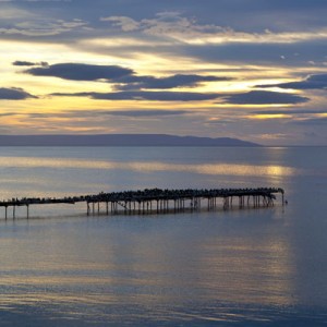
We set sail in the late afternoon, heading for Santa Cruz Island where we had departed a few days earlier. The sea was calm and the sunset was beautiful. This would be the last stop of our trip.