2012.8.28~29From Anchorage to Fairbanks, we would take Glenn Highway (AK-1) and then Richardson Highway (AK-4 and AK-2). We’d go to Denali National Park later in our trip, At that time, we would go back to Anchorage by the shorter route, AK-3, to complete a loop.
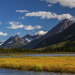
The first 40 miles of the Glenn Highway is the only road access to Anchorage from the north. After this section of the busy road, as we turned east after passing Palmer, the vehicles were getting fewer and fewer. The highway runs along the south side of the Alaska Range and, for the most part, along the Matanuska River. The road is winding and climbs over Eureka Summit at 3,332 ft. There are many pullout places for you to view the beautify valley created by the receding Matanuska Glacier.


The 180-mile Glenn Highway took us almost 5 hours. We stayed over night at Caribou Hotel in Glennallen. Some travelers gave low rating to the hotel, but we found it to be nice and most importantly clean, and the front desk was very helpful too. It’s not cheap, but this is in the middle of nowhere, I don’t think you should expect full facilities.


The next morning, I went back 10 miles along the highway and found the beautify lake we passed by the early night. The view was wonderful in the sunrise.

After having some instant noodles as our breakfast, we were on our way at 9:30am. After 2 miles, we turned left onto the Richardson Highway (AK-4). The highway cut through the Alaska Range at its east end, the view continued to be breathtaking.
, Alaska")
, Alaska")
, Alaska")
AK-4 meets AK-2 at Delta Junction. There are several military bases around the area. Driving through the town, we surprisingly saw a sign as “Chinese Food”. We decided to give it a try. Luckily, it’s eatable. It’s about 3pm, we were 100 miles away from Fairbanks. As we had passed Alaska Range, the view along the road is less impressive.
15 miles south-east to Fairbanks, lies a small city, North Pole, Alaska. After driving the whole day, it felt good to see a meaningful city. Thanks for city’s name, a gift shop named Santa Claus House becomes a popular attraction. We made a stop at the store. It’s a nice place. There was a Santa taking pictures with visitors all the time.

We reached Fairbanks at around 6pm. We would stay two nights in the city.